

B2B00276 55125>55112viaRadio/Inwood/Ideal/OlsonLk/Demont/Gatewy/Water/CtyE/Cent/VadLk/N.Owasso/Vict/CtyE
Un percorso ciclabile con partenza da Woodbury, Minnesota, Stati Uniti.
Panoramica
Su questo percorso
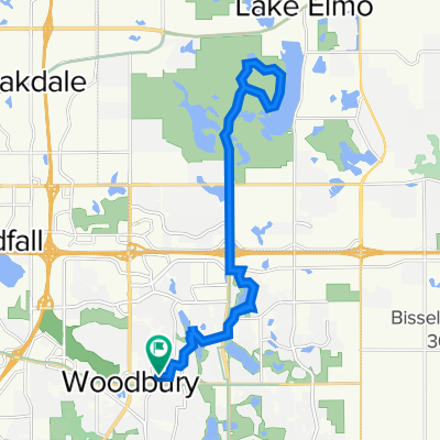
Take Radio Drive north where it becomes Inwood Avenue. Continue on Inwood until you reach Stillwater Blvd (6). Turn left on Stillwater Blvd to Ideal Avenue North. Ideal becomes Olson Lake Trail. Follow Olson Lake Trail around the lake to 50th St. N. Turn right. The road curves to the left and becomes Demontreville Trail N. Follow Demontreville Trail around the lake until you reach Highlands Trail North. Turn left up the hill to Hytrail Av. N and turn left. Follow around until you reach the bike path on your left next to a parking lot. Take this trail to the Gateway Trail. It goes through a little forest and suddenly comes out on the Gateway. Turn right on the Gateway and go through the tunnel under Highway 36. Just past the tunnel turn to the left off the trail to a hairpin turn up to a gravel parking lot. Follow the road (60th St.N) out to Hilton Trail. Turn right on Hilton Trail and turn left at the next intersection, 62nd St. North. Take 62nd to Warner Avenue. Take Warner Avenue to 75th St. N/Stillwater Road. Turn left and follow Stillwater Road through Mahtomedi until you reach Wildwood Road/244. Turn left and continue on Wildwood/244 past Wildwood Pond and up the hill where the road become County Road E. Follow County Road E passing White Bear Avenue, Highway 61, 35E. At Centerville Road turn left. Follow Centerville Road. At the next intersection Centerville becomes Vadnais Blvd. Go straight ahead on Vadnais Blvd. around Lake Vadnais. The road curves around the lake through a forest and through the lake. Up the hill is Rice Street. Turn left at Rice Street and cross over 694. At North Owasso Blvd. turn right. Follow North Owasso past Lake Owasso on your left and continue around the lake until you reach Victoria. Turn right on Victoria Street. Follow Victoria around until you reach County Road E West. Turn left and continue on County Road E to your destination.
- -:--
- Durata
- 33,1 km
- Distanza
- 124 m
- Salita
- 150 m
- Discesa
- ---
- Velocità media
- 315 m
- Altitudine max.
Qualità del percorso
Tipi di percorsi e superfici lungo il percorso
Tipi di percorso
Strada
9 km
(27 %)
Strada tranquilla
8,2 km
(25 %)
Superfici
Asfaltato
18,3 km
(55 %)
Asfalto
16,4 km
(49 %)
Pavimentato (non definito)
1,7 km
(5 %)
Continua con Bikemap
Usa, modifica o scarica questo percorso ciclabile
Vuoi percorrere B2B00276 55125>55112viaRadio/Inwood/Ideal/OlsonLk/Demont/Gatewy/Water/CtyE/Cent/VadLk/N.Owasso/Vict/CtyE o personalizzarlo per il tuo viaggio? Ecco cosa puoi fare con questo percorso su Bikemap:
Funzionalità gratuite
- Salva questo percorso tra i preferiti o in una raccolta
- Copia e pianifica la tua versione di questo percorso
- Sincronizza il tuo percorso con Garmin o Wahoo
Funzionalità Premium
Prova gratuita di 3 giorni o pagamento una tantum. Scopri di più su Bikemap Premium.
- Naviga questo percorso su iOS e Android
- Esporta un file GPX / KML di questo percorso
- Crea la tua stampa personalizzata (provala gratis)
- Scarica questo percorso per la navigazione offline
Scopri altre funzionalità Premium.
Ottieni Bikemap PremiumDalla nostra community
Woodbury: Altri percorsi popolari che iniziano qui
 1208 St Johns Dr, Woodbury to 1208 St Johns Dr, Woodbury
- Distanza
- 8 km
- Salita
- 26 m
- Discesa
- 28 m
- Posizione
- Woodbury, Minnesota, Stati Uniti
 B2B00248 55125>55112 viaRadio/Inwood/Ideal/OlsonLk/Demontr/WarnerRd/Lake/BaldEag/H2/Centv/CtyJ
- Distanza
- 43,7 km
- Salita
- 134 m
- Discesa
- 164 m
- Posizione
- Woodbury, Minnesota, Stati Uniti
 Lake Elmo Ride
- Distanza
- 24,1 km
- Salita
- 113 m
- Discesa
- 113 m
- Posizione
- Woodbury, Minnesota, Stati Uniti
 B2B00770 55125>55101 via Upper Afton Rd, E 6th St
- Distanza
- 15,6 km
- Salita
- 81 m
- Discesa
- 158 m
- Posizione
- Woodbury, Minnesota, Stati Uniti
 B2B00600 55125>55101 via Upper Afton Rd, Mounds Blvd, 6th St E
- Distanza
- 11,2 km
- Salita
- 86 m
- Discesa
- 170 m
- Posizione
- Woodbury, Minnesota, Stati Uniti
 10870 Ashley Ln, Woodbury to 10869 Ashley Ln, Woodbury
- Distanza
- 28,9 km
- Salita
- 178 m
- Discesa
- 177 m
- Posizione
- Woodbury, Minnesota, Stati Uniti
 B2B00288 55125>55344 via Mndt Hght Rd, 494, 86th St
- Distanza
- 46,8 km
- Salita
- 248 m
- Discesa
- 283 m
- Posizione
- Woodbury, Minnesota, Stati Uniti
 IronMAN Relay Route
- Distanza
- 36,2 km
- Salita
- 190 m
- Discesa
- 190 m
- Posizione
- Woodbury, Minnesota, Stati Uniti
Aprila nell’app