

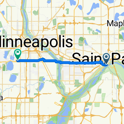
B2B00368 55102 > 55417 via Shepard Rd, Godfrey, Minnehaha, River Pkwy
Un percorso ciclabile con partenza da Saint Paul, Minnesota, Stati Uniti.
Panoramica
Su questo percorso
Take Kellog past 7th St, and veer right onto Eagle Pkwy.
Follow Eagle Pkwy down the hill to Shepard Rd (at the bottom of the hill).
On the river side of Shepard Rd is a bike path.
Take the Shepard Rd bike path all the way to Ford Pkwy. (Note: when you have to cross under 35E, you must follow the trail as it dips out of the way south for a little bit, but it will curve back north, don't worry!)
At Ford Pkwy, take a left and cross the bridge. When you get over the bridge, traffic is iffy for about the equivelant of 1 block. You can walk your bike on the sidewalk for this patch if you dont feel comfortable in the street.
Take a left onto 46th Ave (the first turn you can take once you're over the bridge).
Take 46th Ave down the hill to the stopsign (note: there are bumpy cobblestones for a patch)
Take a rigth onto Godfrey Rd and follow that in the bike path until just before you reach the roundabout, and take a left to head south east on Minnehaha Avenue in the bike path.
Continue on Minnehaha Avenue until your reach 54th St E (note: along the way Minnehaha turns into River pkwy)
Take a right on 54th St. to cross Hiawatha.
Continue on 54th about 2 blocks and take a left onto Minnehaha Avenue.
Continue on Minnehaha to your desination.
- -:--
- Durata
- 17,8 km
- Distanza
- 96 m
- Salita
- 119 m
- Discesa
- ---
- Velocità media
- 264 m
- Altitudine max.
Qualità del percorso
Tipi di percorsi e superfici lungo il percorso
Tipi di percorso
Pista ciclabile
10,7 km
(60 %)
Strada tranquilla
2 km
(11 %)
Superfici
Asfaltato
14,4 km
(81 %)
Non asfaltato
2 km
(11 %)
Asfalto
12,8 km
(72 %)
Ghiaia
1,2 km
(7 %)
Continua con Bikemap
Usa, modifica o scarica questo percorso ciclabile
Vuoi percorrere B2B00368 55102 > 55417 via Shepard Rd, Godfrey, Minnehaha, River Pkwy o personalizzarlo per il tuo viaggio? Ecco cosa puoi fare con questo percorso su Bikemap:
Funzionalità gratuite
- Salva questo percorso tra i preferiti o in una raccolta
- Copia e pianifica la tua versione di questo percorso
- Sincronizza il tuo percorso con Garmin o Wahoo
Funzionalità Premium
Prova gratuita di 3 giorni o pagamento una tantum. Scopri di più su Bikemap Premium.
- Naviga questo percorso su iOS e Android
- Esporta un file GPX / KML di questo percorso
- Crea la tua stampa personalizzata (provala gratis)
- Scarica questo percorso per la navigazione offline
Scopri altre funzionalità Premium.
Ottieni Bikemap PremiumDalla nostra community
Saint Paul: Altri percorsi popolari che iniziano qui
 B2B00192 55102>55404viaShepherdRd/MissBlvd/WRiverPkwy/MidtwnGrnway
- Distanza
- 21,8 km
- Salita
- 131 m
- Discesa
- 86 m
- Posizione
- Saint Paul, Minnesota, Stati Uniti
 B2B00368 55102 > 55417 via Shepard Rd, Godfrey, Minnehaha, River Pkwy
- Distanza
- 17,8 km
- Salita
- 96 m
- Discesa
- 119 m
- Posizione
- Saint Paul, Minnesota, Stati Uniti
 Gateway State Trail
- Distanza
- 30 km
- Salita
- 115 m
- Discesa
- 69 m
- Posizione
- Saint Paul, Minnesota, Stati Uniti
 Jackson Street to East 7th Street
- Distanza
- 1,6 km
- Salita
- 36 m
- Discesa
- 0 m
- Posizione
- Saint Paul, Minnesota, Stati Uniti
 B2B00629 55102 < 55402 via Summit, River Road, West bank, Downtown
- Distanza
- 15,5 km
- Salita
- 82 m
- Discesa
- 94 m
- Posizione
- Saint Paul, Minnesota, Stati Uniti
 St Paul Gateway to: Brown’s creek to Stillwater and back .
- Distanza
- 64,2 km
- Salita
- 408 m
- Discesa
- 409 m
- Posizione
- Saint Paul, Minnesota, Stati Uniti
 To the River Center
- Distanza
- 17,1 km
- Salita
- 117 m
- Discesa
- 90 m
- Posizione
- Saint Paul, Minnesota, Stati Uniti
 B2B00024 55104 > 55121 via Big Rivers Trail
- Distanza
- 16,8 km
- Salita
- 174 m
- Discesa
- 174 m
- Posizione
- Saint Paul, Minnesota, Stati Uniti
Aprila nell’app