

Road cycling. Val d'Aran - Pyrenees: Tour Vielha with Superbagneres
Un percorso ciclabile con partenza da Les, Catalogna, Spagna.
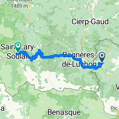
Panoramica
Su questo percorso
Questo percorso inizia a Bossòst, ma potrebbe altrettanto facilmente servire per i ciclisti che soggiornano a Vielha, che potrebbero raggiungere Bossòst lungo le ampie banchine della N-230.
Partiamo da Bossòst, uscendo dalla città verso sud, lungo il fiume Garona, e salendo a destra alla rotonda lungo la N-141. Questo è l'inizio del Portilhon, il colle che segna il confine tra Spagna e Francia. Inizia con una serie di tornanti che offrono splendide viste su Bossòst, sale oltre il Parco Aran e, dopo aver attraversato il confine in cima, scende rapidamente verso la Francia.
A Saint-Mamet, se ti senti in forma, segui la traccia GPS a sinistra dopo aver attraversato il fiume Pique, per dirigerti verso la salita a Superbagnères. Questa salita è una strada senza uscita, il che significa che salirai fino in cima e tornerai a questo punto. Quindi, se preferisci evitarla, svolta a destra dopo aver attraversato il fiume Pique e continua attraverso Bagnères de Luchon.
Se decidi di salire a Superbagnères, la pendenza aumenta abbastanza presto dopo la partenza da Saint-Mamet, includendo rampe al 12% nei primi due chilometri. La salita totale è di 18,5 chilometri ed è per ciclisti esperti. Il dislivello totale è di 1170 m, che ti porta a oltre 1800 m di altitudine, con una pendenza media del 6,3%. Alla fine lascerai la linea degli alberi e il paesaggio si apre su ampi pascoli d'alta quota, con viste su molte delle vette innevate di 3000 m della regione. Una volta raggiunta la stazione sciistica in cima, non resta che tornare indietro e godersi la discesa fino a Bagnères-de-Luchon!
Il percorso ora attraversa Bagnères-de-Luchon da sud a nord, poi segue il fiume Pique lungo la D125 fino a Gaud, dove giriamo a destra al rondò e ci uniamo alla D44 verso Marignac. La D44 è una strada abbastanza facile, che sale molto dolcemente dopo Marignac. Arriviamo nella valle del fiume Garonna e giriamo a destra sulla N125, che continua a salire dolcemente lungo la valle del fiume verso il confine spagnolo.
Punti di interesse: La salita a Superbagnères è una salita di pellegrinaggio per i fan del Tour de France, che hanno assistito a molte battaglie famose tra i migliori ciclisti del mondo sui suoi tornanti. È molto selvaggia e ci sono bei panorami (e suoni) del fiume Lys che scorre impetuoso accanto alla strada lungo il percorso.
- -:--
- Durata
- 90,2 km
- Distanza
- 2.386 m
- Salita
- 2.386 m
- Discesa
- ---
- Velocità media
- ---
- Altitudine max.

Qualità del percorso
Tipi di percorsi e superfici lungo il percorso
Tipi di percorso
Strada
33,4 km
(37 %)
Strada tranquilla
1,8 km
(2 %)
Superfici
Asfaltato
46,9 km
(52 %)
Asfalto
46,9 km
(52 %)
Non definito
43,3 km
(48 %)
Continua con Bikemap
Usa, modifica o scarica questo percorso ciclabile
Vuoi percorrere Road cycling. Val d'Aran - Pyrenees: Tour Vielha with Superbagneres o personalizzarlo per il tuo viaggio? Ecco cosa puoi fare con questo percorso su Bikemap:
Funzionalità gratuite
- Salva questo percorso tra i preferiti o in una raccolta
- Copia e pianifica la tua versione di questo percorso
- Dividilo in tappe per creare un tour di più giorni
- Sincronizza il tuo percorso con Garmin o Wahoo
Funzionalità Premium
Prova gratuita di 3 giorni o pagamento una tantum. Scopri di più su Bikemap Premium.
- Naviga questo percorso su iOS e Android
- Esporta un file GPX / KML di questo percorso
- Crea la tua stampa personalizzata (provala gratis)
- Scarica questo percorso per la navigazione offline
Scopri altre funzionalità Premium.
Ottieni Bikemap PremiumDalla nostra community
Les: Altri percorsi popolari che iniziano qui
 Bossost 2
- Distanza
- 134,3 km
- Salita
- 2.863 m
- Discesa
- 2.866 m
- Posizione
- Les, Catalogna, Spagna
 Road Cycling: Aran - Haute Garonne Loop
- Distanza
- 136,4 km
- Salita
- 4.122 m
- Discesa
- 4.121 m
- Posizione
- Les, Catalogna, Spagna
 PIRINEOS MÍTICOS 2020
- Distanza
- 386,7 km
- Salita
- 14.434 m
- Discesa
- 14.347 m
- Posizione
- Les, Catalogna, Spagna
 Gravel Bike /MTB. Val d'Aran - Pyrenees: Vall de Toran: Les | Pista Portet | Honeria | Canejan | Les
- Distanza
- 36,8 km
- Salita
- 1.211 m
- Discesa
- 1.214 m
- Posizione
- Les, Catalogna, Spagna
 Bossot-Portillon-Peyragudes-Val Louron-Saint Lary Soulan
- Distanza
- 62,4 km
- Salita
- 2.168 m
- Discesa
- 2.057 m
- Posizione
- Les, Catalogna, Spagna
 bossost
- Distanza
- 117,8 km
- Salita
- 2.223 m
- Discesa
- 2.223 m
- Posizione
- Les, Catalogna, Spagna
 1 Luchon
- Distanza
- 156,8 km
- Salita
- 2.652 m
- Discesa
- 2.764 m
- Posizione
- Les, Catalogna, Spagna
 Pombair Tour 2012, 6. Tag
- Distanza
- 96,8 km
- Salita
- 1.617 m
- Discesa
- 1.641 m
- Posizione
- Les, Catalogna, Spagna
Aprila nell’app