

Poenari Citadel, Romania
Un percorso ciclabile con partenza da Căpățânenii Pământeni, distretto di Argeș, Romania.
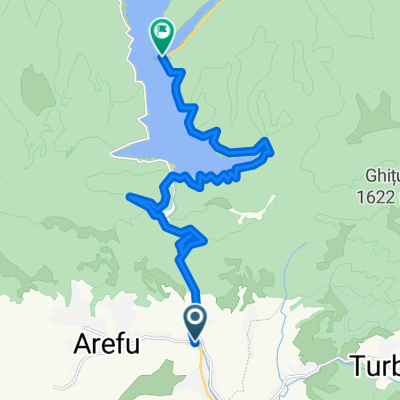
Panoramica
Su questo percorso
Il Castello di Poenari, noto anche come Cittadella di Poenari, è un castello in rovina in Romania che fu la dimora di Vlad l’Impalatore. L’accesso alla cittadella è possibile salendo i 1.480 gradini in cemento.
Il Castello di Poenari fu costruito intorno all’inizio del XIII secolo dai Valacchi. Intorno al XIV secolo, Poenari (allora noto come Castello di Arges) era la principale cittadella dei sovrani Basarab. Nel corso dei decenni successivi, il nome e i residenti cambiarono più volte, ma alla fine il castello fu abbandonato e lasciato in rovina.
Tuttavia, nel XV secolo, rendendosi conto del potenziale di un castello arroccato in alto su un ripido precipizio roccioso, Vlad III l’Impalatore riparò e consolidò la struttura schiavizzando i suoi nemici della nobiltà dei Principati Danubiani della Valacchia e della Moldova, facendolo diventare una delle sue principali fortezze, ricostruendo l’ex Castello di Arges sulla sponda sinistra del fiume con pietre del vecchio Castello di Poenari, che si trovava sulla riva destra e un po’ più in basso. Sebbene il castello sia stato utilizzato per molti anni dopo la morte di Vlad nel 1476, alla fine venne abbandonato nuovamente nella prima metà del XVI secolo e cadde in rovina nel XVII secolo. Le dimensioni e la posizione del castello ne rendevano difficile la conquista. Il 13 gennaio 1913, una frana causata da un terremoto fece crollare parti del castello che caddero nel fiume molto più in basso. Dopo altri due terremoti nel 1940 e nel 1977 che causarono ulteriori danni, è stato leggermente riparato e le mura e le torri sono ancora oggi in piedi. Dal 2009, il sito è gestito dal Museo della Contea di Argeș.
- -:--
- Durata
- 18,3 km
- Distanza
- 683 m
- Salita
- 446 m
- Discesa
- ---
- Velocità media
- ---
- Altitudine max.
Qualità del percorso
Tipi di percorsi e superfici lungo il percorso
Tipi di percorso
Scale
1,6 km
(9 %)
Strada tranquilla
0,4 km
(2 %)
Superfici
Asfaltato
17,4 km
(95 %)
Non asfaltato
0,4 km
(2 %)
Asfalto
15,7 km
(86 %)
Calcestruzzo
1,6 km
(9 %)
Continua con Bikemap
Usa, modifica o scarica questo percorso ciclabile
Vuoi percorrere Poenari Citadel, Romania o personalizzarlo per il tuo viaggio? Ecco cosa puoi fare con questo percorso su Bikemap:
Funzionalità gratuite
- Salva questo percorso tra i preferiti o in una raccolta
- Copia e pianifica la tua versione di questo percorso
- Sincronizza il tuo percorso con Garmin o Wahoo
Funzionalità Premium
Prova gratuita di 3 giorni o pagamento una tantum. Scopri di più su Bikemap Premium.
- Naviga questo percorso su iOS e Android
- Esporta un file GPX / KML di questo percorso
- Crea la tua stampa personalizzata (provala gratis)
- Scarica questo percorso per la navigazione offline
Scopri altre funzionalità Premium.
Ottieni Bikemap PremiumDalla nostra community
Căpățânenii Pământeni: Altri percorsi popolari che iniziano qui
 Transfagarasan - Arges
- Distanza
- 124 km
- Salita
- 1.778 m
- Discesa
- 1.778 m
- Posizione
- Căpățânenii Pământeni, distretto di Argeș, Romania
 Capataneni-Vidraru-SpreLespezi-Intoarcere-Arefu
- Distanza
- 54,3 km
- Salita
- 1.484 m
- Discesa
- 1.484 m
- Posizione
- Căpățânenii Pământeni, distretto di Argeș, Romania
![[2015.05.09] Tura Vidraru 2015 Edit](https://media.bikemap.net/routes/3308243/staticmaps/in_0edac5df-8255-43b3-abc6-84be3d0cfdb1_400x400_bikemap-2021-3D-static.png) [2015.05.09] Tura Vidraru 2015 Edit
[2015.05.09] Tura Vidraru 2015 Edit- Distanza
- 46,2 km
- Salita
- 1.190 m
- Discesa
- 1.190 m
- Posizione
- Căpățânenii Pământeni, distretto di Argeș, Romania
 Arefu-Capra
- Distanza
- 55 km
- Salita
- 1.584 m
- Discesa
- 667 m
- Posizione
- Căpățânenii Pământeni, distretto di Argeș, Romania
 TF - Brezoi - TA ziua 2
- Distanza
- 49,8 km
- Salita
- 701 m
- Discesa
- 995 m
- Posizione
- Căpățânenii Pământeni, distretto di Argeș, Romania
 Capataneni - Cartisoara - Fagaras - Codlea - Bran - Campulung - Schitu Golesti
- Distanza
- 275,6 km
- Salita
- 2.366 m
- Discesa
- 2.495 m
- Posizione
- Căpățânenii Pământeni, distretto di Argeș, Romania
 Poenari Citadel, Romania
- Distanza
- 18,3 km
- Salita
- 683 m
- Discesa
- 446 m
- Posizione
- Căpățânenii Pământeni, distretto di Argeș, Romania
 Transfagarasan - Sud-Nord, Arefu-Cartisoara
- Distanza
- 93,3 km
- Salita
- 1.704 m
- Discesa
- 1.820 m
- Posizione
- Căpățânenii Pământeni, distretto di Argeș, Romania
Aprila nell’app