Around Mount Warning
Un percorso ciclabile con partenza da Murwillumbah, Nuovo Galles del Sud, Australia.
Panoramica
Su questo percorso
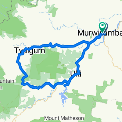
Iniziamo da Uki e viaggiamo verso est e poi verso nord lungo la Kyogle Road seguendo il fiume Tweed. A circa 10 km, giriamo a sinistra sulla Tyalgum Road che segue il fiume Oxley. Ci fermiamo a Tyalgum per un tè mattutino. Poi ci dirigiamo a sud sulla Brays Creek Road. A 33 km giriamo a sinistra sulla Byrrill Creek Road. Salendo costantemente attraverso la boscaglia su una strada non asfaltata. Al 38° km iniziamo a scendere con scorci del Byrrill Creek a destra e del Monte Warning a sinistra. A 49,8 km giriamo a sinistra sulla Kyogle Road che seguiamo fino a Uki. Pranzo a Uki nel parco o al caffè o pub.
- -:--
- Durata
- 56,2 km
- Distanza
- 808 m
- Salita
- 806 m
- Discesa
- ---
- Velocità media
- ---
- Altitudine max.
Qualità del percorso
Tipi di percorsi e superfici lungo il percorso
Tipi di percorso
Strada
18,5 km
(33 %)
Strada tranquilla
18,5 km
(33 %)
Non definito
19,1 km
(34 %)
Superfici
Asfaltato
47,2 km
(84 %)
Non asfaltato
9,6 km
(17 %)
Asfalto
43,3 km
(77 %)
Non asfaltato (non definito)
9,6 km
(17 %)
Continua con Bikemap
Usa, modifica o scarica questo percorso ciclabile
Vuoi percorrere Around Mount Warning o personalizzarlo per il tuo viaggio? Ecco cosa puoi fare con questo percorso su Bikemap:
Funzionalità gratuite
- Salva questo percorso tra i preferiti o in una raccolta
- Copia e pianifica la tua versione di questo percorso
- Sincronizza il tuo percorso con Garmin o Wahoo
Funzionalità Premium
Prova gratuita di 3 giorni o pagamento una tantum. Scopri di più su Bikemap Premium.
- Naviga questo percorso su iOS e Android
- Esporta un file GPX / KML di questo percorso
- Crea la tua stampa personalizzata (provala gratis)
- Scarica questo percorso per la navigazione offline
Scopri altre funzionalità Premium.
Ottieni Bikemap PremiumDalla nostra community
Murwillumbah: Altri percorsi popolari che iniziano qui
 S3 Murwillumban - Advancetown Lake - Nerang
- Distanza
- 66,1 km
- Salita
- 700 m
- Discesa
- 680 m
- Posizione
- Murwillumbah, Nuovo Galles del Sud, Australia
 Murwillumbah to Coolangata beach circuit
- Distanza
- 67,3 km
- Salita
- 1.132 m
- Discesa
- 1.135 m
- Posizione
- Murwillumbah, Nuovo Galles del Sud, Australia
 Northern Rivers Rail Trail (N>S)
- Distanza
- 24,2 km
- Salita
- 206 m
- Discesa
- 179 m
- Posizione
- Murwillumbah, Nuovo Galles del Sud, Australia
 Stokers Road 288, Stokers Siding to Tweed Valley Way 284, South Murwillumbah
- Distanza
- 7,5 km
- Salita
- 7 m
- Discesa
- 58 m
- Posizione
- Murwillumbah, Nuovo Galles del Sud, Australia
 18 around the Mount Warning
- Distanza
- 69,2 km
- Salita
- 402 m
- Discesa
- 405 m
- Posizione
- Murwillumbah, Nuovo Galles del Sud, Australia
 Murwillimbah to Kyogle
- Distanza
- 78,7 km
- Salita
- 1.614 m
- Discesa
- 1.555 m
- Posizione
- Murwillumbah, Nuovo Galles del Sud, Australia
 284 Tweed Valley Way, South Murwillumbah to 284 Tweed Valley Way, South Murwillumbah
- Distanza
- 51,3 km
- Salita
- 386 m
- Discesa
- 384 m
- Posizione
- Murwillumbah, Nuovo Galles del Sud, Australia
 Recorded on 13 Oct 2023 at 16:31
- Distanza
- 25,4 km
- Salita
- 236 m
- Discesa
- 228 m
- Posizione
- Murwillumbah, Nuovo Galles del Sud, Australia
Aprila nell’app


