
Moje zapisane trasy
Kolekcja 7 tras rowerowych, utworzona przez Norbert Ower.
Przegląd
O tej kolekcji
This collection contains all routes that were previously saved.
- 7
- Trasy
- -:--
- Czas
- 261,3 km
- Dystans
- ---
- Śr. Prędkość
- 3037 m
- Przewyższenia
- 4119 m
- Spadek
utworzono 9 lat temu temu
Moje zapisane trasy
Trasy w tej kolekcji
Wszystkie 7 trasy z tej kolekcji można otworzyć na mapie lub w aplikacji Bikemap, aby uzyskać więcej informacji. Możesz je dostosować w planerze tras lub pobrać jako plik GPX lub KML. Użyj ich jako szablonu do planowania własnych przejazdów lub pozwól Bikemap prowadzić cię bezpośrednio.

38km Rund um Bad Dürrheim
Trasa rowerowa w Bad Dürrheim, Badenia-Wirtembergia, Niemcy
- 38,4 km
- Dystans
- 398 m
- Przewyższenia
- 380 m
- Spadek

Runde um die Insel Reichenau
Trasa rowerowa w Reichenau, Badenia-Wirtembergia, Niemcy
- 14,3 km
- Dystans
- 53 m
- Przewyższenia
- 53 m
- Spadek

Schluchsee Rundkurs
Trasa rowerowa w Schluchsee, Badenia-Wirtembergia, Niemcy
- 18,6 km
- Dystans
- 407 m
- Przewyższenia
- 407 m
- Spadek

Black Forest Ultra Bike 42km
Trasa rowerowa w Hinterzarten, Badenia-Wirtembergia, Niemcy
- 40,1 km
- Dystans
- 753 m
- Przewyższenia
- 1290 m
- Spadek

Maitour 40
Trasa rowerowa w Zimmern ob Rottweil, Badenia-Wirtembergia, Niemcy
- 39,4 km
- Dystans
- 504 m
- Przewyższenia
- 524 m
- Spadek

Südschwarzwald-Radweg 1
Trasa rowerowa w Hinterzarten, Badenia-Wirtembergia, Niemcy
- 89,9 km
- Dystans
- 239 m
- Przewyższenia
- 782 m
- Spadek
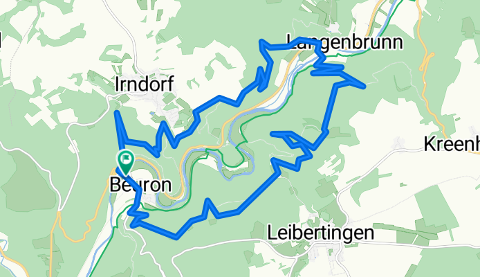
Donautalrundweg
- 20,5 km
- Dystans
- 683 m
- Przewyższenia
- 683 m
- Spadek