International routes

International routes

Kolekcja 29 tras rowerowych, utworzona przez Raphaël Clerici.

Przegląd

O tej kolekcji

Long distance international routes in Europe

29
Trasy
218 h 15 min
Czas
34 427,1 km
Dystans
157,7 km/h
Śr. Prędkość
91 296 m
Przewyższenia
93 535 m
Spadek
Raphaël Clerici
Raphaël Clerici

utworzono 2 lata temu temu

International routes

Trasy w tej kolekcji

Wszystkie 29 trasy z tej kolekcji można otworzyć na mapie lub w aplikacji Bikemap, aby uzyskać więcej informacji. Możesz je dostosować w planerze tras lub pobrać jako plik GPX lub KML. Użyj ich jako szablonu do planowania własnych przejazdów lub pozwól Bikemap prowadzić cię bezpośrednio.

Eurovelo 12 Elbe shortcut
Utwardzony
Raphaël Clerici
0

Eurovelo 12 Elbe shortcut

Trasa rowerowa w Cuxhaven, Lower Saxony, Germany

Le ferry Cuxhaven-Brunsbüttel pour traverser l’Elbe ne navigue plus depuis fin 2021, victime de la pandémie de Covid. Par conséquent, le nouveau tracé de la véloroute de la mer du Nord (North Sea Cycle Route, Eurovelo 12), passe par Hambourg. Malgré l’intérêt évident que représente cette magnifique métropole nordique, le détour pourra rebuter certain-e-s, impatient-e-s de monter vers la Scandinavie. Il existe toutefois un raccourci, via le ferry Wischhafen-Glückstadt, à 50 km en amont de Cuxhaven. This map shows a shortcut between Cuxhaven and Brunsbüttel, following the shutdown in 2021 of the former direct ferry service. If you are in a hurry and do not want to visit the beautiful city of Hamburg, you can take the Wischhafen-Glückstadt ferry to continue on Eurovelo 12. Distance : 81 km Dénivelé positif : 0 m Durée : 5 heures Plus d'informations sur www.europebybike.info
80,5 km
Dystans
0 m
Przewyższenia
0 m
Spadek
Les plats pays (Bâle-Bruxelles-Amsterdam-Hambourg)
UtwardzonyNieutwardzonyŻwir
Raphaël Clerici
8

Les plats pays (Bâle-Bruxelles-Amsterdam-Hambourg)

Trasa rowerowa w Basel, Canton of Basel-Stadt, Switzerland

De Bâle à Hambourg par les Vosges, la Moselle, le Luxembourg, la Belgique et la Hollande. A l'exception de la France, le parcours suit presque exclusivement des pistes cyclables et voies vertes. Vélo robuste et pneus anti-crevaison recommandés pour les sections hors goudron. From Basle to Hamburg, via France, Luxemburg, Belgium and The Netherlands. This route mainly follows official cycle paths free from motorized traffic, except in France where we ride on secondary roads. Strong bike with anti-puncture tyres recommended for the unpaved sections. Distance : 2095 km Dénivelé positif : 8000 m Durée : 121 heures (sur 24 jours) Plus d'informations sur www.europebybike.info
1978,4 km
Dystans
7000 m
Przewyższenia
7266 m
Spadek
Eurovelo 10/13 : Nida - Narva (LT, LV, EST)
Utwardzony
Raphaël Clerici
1

Eurovelo 10/13 : Nida - Narva (LT, LV, EST)

Trasa rowerowa w

De la frontière russe de Kaliningrad à celle d'Ivangorod par la véloroute de la Baltique (Eurovelo 10 & 13) et quelques variantes, à travers la Lituanie, la Lettonie et l'Estonie. Itinéraire comportant de nombreux passages hors goudron, sur routes de gravier ou chemins sablonneux. Vélo robuste et pneus anti-crevaison indispensables ! Distance : 1750 km Dénivelé positif : 1800 m Durée : 92 heures (sur 17 jours) Plus d'informations sur www.europebybike.info
1539,9 km
Dystans
1091 m
Przewyższenia
1094 m
Spadek
Helsinki - Mariehamn
UtwardzonyNieutwardzony
Raphaël Clerici
14

Helsinki - Mariehamn

Trasa rowerowa w Helsinki, Uusimaa, Finland

De Helsinki à Mariehamn par la véloroute de la Baltique (Eurovelo 10) et celle de l'archipel d'Åland (secteur sud). Itinéraire comportant quelques passages hors goudron, sur routes de terre battue. Vélo robuste et pneus anti-crevaison recommandés. Connexions en ferry. Distance : 477 km Dénivelé positif : 3000 m Durée : 27 heures (sur 6 jours) Plus d'informations sur www.europebybike.info
531,6 km
Dystans
330 m
Przewyższenia
329 m
Spadek
Stockholm - Karlskrona
UtwardzonyNieutwardzonyŻwir
Raphaël Clerici
21

Stockholm - Karlskrona

Trasa rowerowa w Stockholm, Stockholm County, Sweden

De Stockholm à Karlskrona par les véloroutes Kustlinjen, Cykelspåret et quelques variantes personnelles, en particulier sur l'île d'Öland. Itinéraire comportant des passages hors goudron, sur routes de terre battue ou de gravier. Vélo robuste et pneus anti-crevaison vivement recommandés. Connexions en ferry. Distance : 690 km Dénivelé positif : 3500 m Durée : 34 heures (sur 7 jours) Plus d'informations sur www.europebybike.info
707 km
Dystans
356 m
Przewyższenia
360 m
Spadek
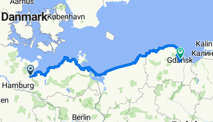
Eurovelo 10/13 : Lübeck - Gdansk
Utwardzony
Raphaël Clerici
24

Eurovelo 10/13 : Lübeck - Gdansk

Trasa rowerowa w Lübeck, Schleswig-Holstein, Germany

De Lübeck (Allemagne) à Gdansk (Pologne) en suivant la véloroute de la Baltique (Eurovelo 10 & 13). Itinéraire principalement hors trafic comportant de nombreux passages hors goudron, sur chemins caillouteux ou sablonneux. Vélo robuste et pneus anti-crevaison indispensables ! Distance : 1025 km Dénivelé positif : 2000 m Durée : 67 heures (sur 11 jours) Plus d'informations sur www.europebybike.info
938,5 km
Dystans
331 m
Przewyższenia
341 m
Spadek
Sweden and Denmark 2018
Utwardzony
Raphaël Clerici
0

Sweden and Denmark 2018

Trasa rowerowa w Borlänge, Dalarna County, Sweden

Great tour in Sweden following the Sverigeleden bike routes network, followed by a north to south crossing of Jutland in Denmark along Eurovelo 3. Fully signposted itinerary, mainly on secondary roads with very little or no traffic. Some sections on gravel roads, much tougher in Denmark than in Sweden, so a strong touring bike with puncture proof tyres is highly recommended. Malung to Borlänge by bus as riding on E16 would be suicidal - and cycling back the 160 km via Evertsberg not very cool, as well as dangerous in this very hot and dry summer (forest fires !). Falköping to Göteborg by train. Total distance : 1600 km Total climb : 8200 m Number of days : 16 (88 hours) Plus d'informations sur www.europebybike.info
1465,6 km
Dystans
1065 m
Przewyższenia
1172 m
Spadek
Poole to Land's End
Rower szosowyUtwardzony
Raphaël Clerici
7

Poole to Land's End

Trasa rowerowa w

From Poole (Dorset) to Land's End (Cornwall) along sections of National Cycle Network Routes number 2, 279, 27, 3 and a few unsigned countryside roads. Return from Land's End to Penzance (Railway station) included. Strong touring bike with wide puncture-proof tyres highly recommended. Total distance : 485 km Total climb : around 8000 m Number of days : 6 More information on www.europebybike.info and www.sustrans.org.uk
451,4 km
Dystans
1522 m
Przewyższenia
1512 m
Spadek
Cardiff to Holyhead (NCN Route 8)
Rower szosowyUtwardzonyNieutwardzony
Raphaël Clerici
38

Cardiff to Holyhead (NCN Route 8)

Trasa rowerowa w Cardiff, Wales, United Kingdom

Across Wales from Cardiff to Holyhead along National Cycle Network Route 8 and some obvious shortcuts. Strong touring bike with wide puncture-proof tyres highly recommended. Total distance : 409 km Total climb : 5000 m Number of days : 5 More information on www.europebybike.info and www.sustrans.org.uk
391,6 km
Dystans
1230 m
Przewyższenia
1244 m
Spadek
Mallow to Ballycastle (Ireland)
Rower szosowyUtwardzonyNieutwardzony
Raphaël Clerici
4

Mallow to Ballycastle (Ireland)

Trasa rowerowa w Mallow, Munster, Ireland

From Mallow (County Cork, Republic of Ireland) to Ballycastle (County Antrim, Northern Ireland) on quiet secondary roads most of the time. Strong touring bike with wide puncture-proof tyres highly recommended. Total distance : 1000 km Total climb : 10'000 m Number of days : 12 (56 hours) More information on www.europebybike.info
974,9 km
Dystans
1137 m
Przewyższenia
1194 m
Spadek
Campbeltown - Oban - Outer Hebrides (Scotland)
Rower szosowyUtwardzony
Raphaël Clerici
0

Campbeltown - Oban - Outer Hebrides (Scotland)

Trasa rowerowa w Campbeltown, Scotland, United Kingdom

From Campbeltown (Kintyre) to Oban, alternately on main road and Cycle Route 78. Then across the Outer Hebrides, from Barra in the south to Stornoway on the Isle of Lewis, followed by a half-day ride from Ullapool to Garve on the mainland to catch the train to Inverness. Strong touring bike with wide puncture-proof tyres highly recommended. Total distance : 441 km Total climb : 4000 m Number of days : 6 (23 hours) More information on www.europebybike.info and www.sustrans.org.uk
422,4 km
Dystans
1095 m
Przewyższenia
1025 m
Spadek
Via Francigena 1ère partie (Orsières - Passo della Cisa)
Rower górskiUtwardzony
Raphaël Clerici
1

Via Francigena 1ère partie (Orsières - Passo della Cisa)

Trasa rowerowa w Orsières, Valais, Switzerland

Chemin de pèlerinage parcouru en l'an 990 par Sigéric, archevêque de Canterbury, la Via Francigena relie le sud de l'Angleterre à la tombe de l'apôtre Pierre, à Rome. L'itinéraire proposé ici est celui que j'ai suivi, au départ d'Orsières (Valais, Suisse). VTT indispensable pour franchir les nombreux passages hors goudron - les routes italiennes sont très dangereuses ! 1ère partie : Orsières - Passo della Cisa (6-7 jours) Pour des raisons de sécurité (trafic), prendre à Martigny le train pour Orsières. Distance totale (Orsières-Rome) : 1057 km Dénivelé positif total : 10'500 m Durée : 13 jours (+ repos éventuel) Plus d'informations sur www.europebybike.info
470,4 km
Dystans
2724 m
Przewyższenia
2592 m
Spadek