Jens Erik trip 2024

Jens Erik trip 2024

Wyprawa rowerowa z 8 etapów, rozpoczynająca się w Fidenza, Emilia-Romagna, Italy.

Przegląd

O tej trasie

Ta wycieczka rowerowa ma 8 etapów i łączną długość 438,4 km.

8
Trasy
26 h 54 min
Czas
438,4 km
Dystans
16,3 km/h
Śr. Prędkość
1265 m
Przewyższenia
1253 m
Spadek
Claudio Pedroni
Claudio Pedroni

utworzono 1 rok temu temu

Jens Erik trip 2024

Etapy tej wycieczki

Wszystkie 8 etapy tej wycieczki można otworzyć na mapie lub w aplikacji Bikemap, aby uzyskać więcej szczegółów, gdzie możesz dostosować je w planerze tras lub pobrać jako plik GPX lub KML. Wykorzystaj je jako szablon do planowania własnej wycieczki lub pozwól Bikemap prowadzić Cię bezpośrednio po nich.

29 Sept from Fidenza to Parma (H Tre Ville), flat route
Rower miejskiUtwardzony
Claudio Pedroni
0

29 Sept from Fidenza to Parma (H Tre Ville), flat route

Trasa rowerowa w Fidenza, Emilia-Romagna, Italy

Flat itinerary that joins Fidenza with Parma through the points of interest of Labirinto di Masone, the ancient Cistercian Abbey of Fontevivo, Fontanellato with the castle, the parish church of San Ginesio, San Secondo with the castle and the cycle embankments of the Taro river and of the Parma stream to reach Parma. Itinerario di pianura che unisce Fidenza con Parma attraverso i punti di interesse Labirinto di Masone, l'antica Abbazia Cistercense di Fontevivo, Fontanellato con il castello, la pieve di San Ginesio San Secondo con il castello e gli argini ciclabili del fiume Taro e del torrente Parma per giungere a Parma.
47 km
Dystans
63 m
Przewyższenia
94 m
Spadek
1 Oct Parma to Reggio Emilia via Montechiarugolo -Montecchio
Rower górskiRower miejskiUtwardzony
Claudio Pedroni
0

1 Oct Parma to Reggio Emilia via Montechiarugolo -Montecchio

Trasa rowerowa w Parma, Emilia-Romagna, Italy

From Parma we take the cycle path along the Via Emilia towards Reggio to take via XXIV Maggio on the right in traffic after the San Lazzaro arch and then the Budellungo road, still with traffic until passing the big roundabout. We pass the spa center of Monticelli then on the cycle path to Basilicagoiano up to Montechiarugolo with its beautiful inhabited castle on the edge of the Enza river where we descend along a river road until the hydraulic works where we can pass to the right bank or in the province of Reggio Emilia. We cross the town of Montecchio with its castle. We continue east along secondary roads to Cavriago then on the cycle path to the city center. Da Parma prendiamo la ciclabile in fregio alla via Emilia direzione Reggio per prendere a destra via XXIV Maggio nel traffico dopo l’arco di San Lazzaro quindi la strada Budellungo ancora con traffico fino al superamento della tangenziale. Si passa il centro termale di Monticelli quindi su ciclabile a Basilicagoiano fino a Montechiarugolo con il suo bel castello abitato sul bordo del fiume Enza dove si scende per una strada fluviale fino al manufatto dell’opera idraulica dove possiamo passare in sponda destra ovvero in provincia di Reggio Emilia. Attraversiamo l’abitato di Montecchio con il suo castello. Proseguiamo verso est lungo strade secondarie fino a Cavriago quindi su pista ciclabile fino al centro città.
46,3 km
Dystans
164 m
Przewyższenia
158 m
Spadek
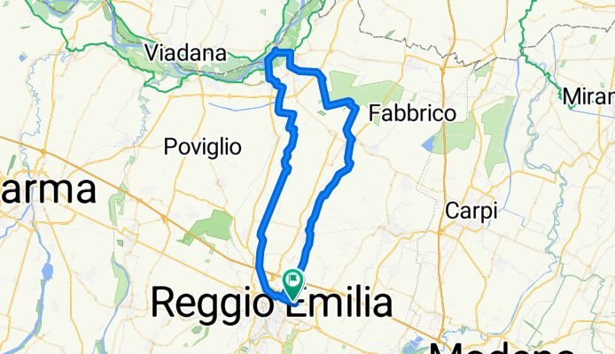
2 Oct Route Reggio Emilia to river Po
Rower górskiRower miejskiUtwardzony
Claudio Pedroni
0

2 Oct Route Reggio Emilia to river Po

Trasa rowerowa w Reggio nell'Emilia, Emilia-Romagna, Italy

A route that stitches together stretches of cycle paths with stretches of minor roads crossing the plain from south to north in the "small capitals" of the history of the possessions of the Bentivoglio and Gonzaga families in the province of Reggio Emilia until reaching the Po river. We cross Bagnolo in Piano, Novellara and the suggestive territory of the Valleys, Guastalla with its Romanesque parish churches, the Palazzo Ducale up to the Lido Po at the old mooring of the pontoon bridge. From the Lido a floating bridge allows us to cross the Crostolo stream at the mouth of the Po and continue towards Gualtieri along the towpath which is now a cycle path. After a stop in the beautiful Piazza Bentivoglio (a square of 100 meters on each side) we return to Reggio Emilia, the embankment of the Crostolo stream, then the minor roads up to the town of Sesso and then the urban cycle paths to enter the city Percorso che ricuce tratti di piste ciclabili con tratti su viabilità minore attraversando la pianura da sud a nord nelle “piccole capitali” della storia dei possedimenti dei Bentivoglio e dei Gonzaga della provincia di Reggio Emilia fino da arrivare al fiume Po. Attraversiamo Bagnolo in Piano, Novellara e il territorio suggestivo delle Valli, Guastalla con le sue pievi romaniche il Palazzo Ducale fino al Lido Po in corrispondenza del vecchio attracco del ponte di barche. Dal Lido un ponte flottante ci consente di passare il torrente Crostolo alla foce del Po e di proseguire per Gualtieri lungo la strada alzaia oggi pista ciclabile. Dopo una sosta nella bella Piazza Bentivoglio (un quadrato di 100 metri di lato) ritorniamo a Reggio Emilia l’argine del torrente Crostolo quindi la viabilità minore fino all’abitato di Sesso e quindi le ciclabili urbane per entrare in città
71,4 km
Dystans
82 m
Przewyższenia
79 m
Spadek
3 Oct Reggio Emilia Nonantola Modena def
Rower szosowyRower miejskiUtwardzony
Claudio Pedroni
0

3 Oct Reggio Emilia Nonantola Modena def

Trasa rowerowa w Reggio nell'Emilia, Emilia-Romagna, Italy

67 km
Dystans
88 m
Przewyższenia
98 m
Spadek
4 Oct Modena to Vignola (Casona Formica)
Rower górskiRower miejskiUtwardzonyNieutwardzonyŻwir
Claudio Pedroni
0

4 Oct Modena to Vignola (Casona Formica)

Trasa rowerowa w Modena, Emilia-Romagna, Italy

The route deviates from the former Modena Vignola railway track for 2024 and early 25 due to road work in the San Donnino area Il percorso devia dal sedime ex ferrovia Modena Vignola per il 2024 e inizio 25 causa lavori in zona San Donnino
53,5 km
Dystans
492 m
Przewyższenia
414 m
Spadek
5 Oct Vignola to Bologna by Castelfranco
Utwardzony
Claudio Pedroni
0

5 Oct Vignola to Bologna by Castelfranco

Trasa rowerowa w Formica, Emilia-Romagna, Italy

61,7 km
Dystans
131 m
Przewyższenia
168 m
Spadek
6 Oct, Bologna - Chiusa del Reno ring
Rower miejskiUtwardzony
Claudio Pedroni
5

6 Oct, Bologna - Chiusa del Reno ring

Trasa rowerowa w Bologna, Emilia-Romagna, Italy

19,9 km
Dystans
164 m
Przewyższenia
163 m
Spadek
2 Oct Route Reggio Emilia to river Po
Rower górskiRower miejskiUtwardzony
Claudio Pedroni
0

2 Oct Route Reggio Emilia to river Po

Trasa rowerowa w Reggio nell'Emilia, Emilia-Romagna, Italy

A route that stitches together stretches of cycle paths with stretches of minor roads crossing the plain from south to north in the "small capitals" of the history of the possessions of the Bentivoglio and Gonzaga families in the province of Reggio Emilia until reaching the Po river. We cross Bagnolo in Piano, Novellara and the suggestive territory of the Valleys, Guastalla with its Romanesque parish churches, the Palazzo Ducale up to the Lido Po at the old mooring of the pontoon bridge. From the Lido a floating bridge allows us to cross the Crostolo stream at the mouth of the Po and continue towards Gualtieri along the towpath which is now a cycle path. After a stop in the beautiful Piazza Bentivoglio (a square of 100 meters on each side) we return to Reggio Emilia, the embankment of the Crostolo stream, then the minor roads up to the town of Sesso and then the urban cycle paths to enter the city Percorso che ricuce tratti di piste ciclabili con tratti su viabilità minore attraversando la pianura da sud a nord nelle “piccole capitali” della storia dei possedimenti dei Bentivoglio e dei Gonzaga della provincia di Reggio Emilia fino da arrivare al fiume Po. Attraversiamo Bagnolo in Piano, Novellara e il territorio suggestivo delle Valli, Guastalla con le sue pievi romaniche il Palazzo Ducale fino al Lido Po in corrispondenza del vecchio attracco del ponte di barche. Dal Lido un ponte flottante ci consente di passare il torrente Crostolo alla foce del Po e di proseguire per Gualtieri lungo la strada alzaia oggi pista ciclabile. Dopo una sosta nella bella Piazza Bentivoglio (un quadrato di 100 metri di lato) ritorniamo a Reggio Emilia l’argine del torrente Crostolo quindi la viabilità minore fino all’abitato di Sesso e quindi le ciclabili urbane per entrare in città
71,4 km
Dystans
82 m
Przewyższenia
79 m
Spadek