
Route Verte 6
Route Verte 6 (Québec)
Wyprawa rowerowa z 4 etapami, rozpoczynająca się w L'Ancienne-Lorette, Québec, Kanada.
Przegląd
O tej trasie
Należący do sieci Route Verte w Quebecu, ten odcinek Route Verte 6 to w dużej mierze wydzielona ścieżka rowerowa z dużą ilością luźnego żwiru i trochę gładkiego asfaltu. Myśl o klimacie zielonej ścieżki z płynnym, falistym terenem, a nie wielkimi podjazdami.
Około 90 km od końca do końca, z około 600 m sumy przewyższenia, więc poczujesz to, ale trasa jest bardzo przejezdna w spokojnym tempie. Spodziewaj się długich odcinków żwirowych, kilku krótkich drewnianych pomostów lub mostków oraz dużo cichej scenerii.
Najlepiej z szerszymi oponami (35–40 mm lub więcej) i prostym zestawem narzędzi; nawierzchnia często zmienia się między żwirem a asfaltem. Zabierz wodę i przekąski — usługi mogą być rozłożone w zależności od miejsca startu.
Przejezdna od późnej wiosny do jesieni, aby mieć najlepsze warunki. Świetna jako solidna trasa na jeden dzień lub podzielona na łatwą nocleg, jeśli chcesz się zatrzymać dłużej.
- 4
- Trasy
- -:--
- Czas
- 89,8 km
- Dystans
- ---
- Śr. Prędkość
- 604 m
- Przewyższenia
- 400 m
- Spadek
Route Verte 6 (Québec)
Etapy tej wycieczki
Wszystkie 4 etapy tej wycieczki można otworzyć na mapie lub w aplikacji Bikemap, aby uzyskać więcej szczegółów, gdzie możesz dostosować je w planerze tras lub pobrać jako plik GPX lub KML. Wykorzystaj je jako szablon do planowania własnej wycieczki lub pozwól Bikemap prowadzić Cię bezpośrednio po nich.
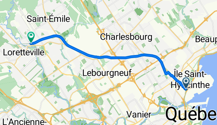
Corridor des Cheminots
Trasa rowerowa w L'Ancienne-Lorette, Québec, Kanada
- 12,2 km
- Dystans
- 130 m
- Przewyższenia
- 0 m
- Spadek
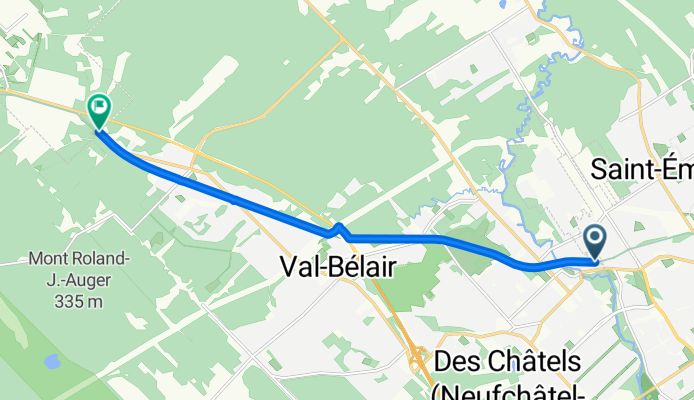
Corridor des Cheminots
Trasa rowerowa w Shannon, Québec, Kanada
- 9,5 km
- Dystans
- 46 m
- Przewyższenia
- 13 m
- Spadek
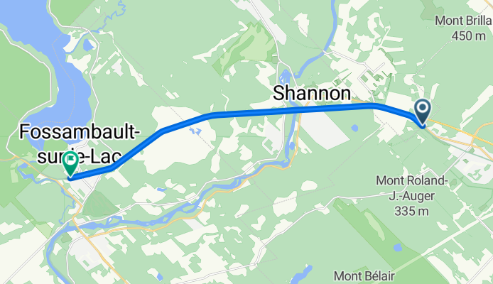
Vélopiste Jacques-Cartier / Portneuf
Trasa rowerowa w Sainte Catherine de la Jacques Cartier, Québec, Kanada
- 12,4 km
- Dystans
- 24 m
- Przewyższenia
- 32 m
- Spadek
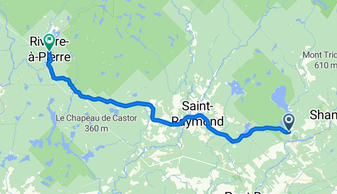
Vélopiste Jacques-Cartier / Portneuf
- 55,7 km
- Dystans
- 404 m
- Przewyższenia
- 356 m
- Spadek