
Synoikismós Chavaríou na rowerze
Odkrywaj mapę z 3 trasami rowerowymi i szlakami w pobliżu Synoikismós Chavaríou, stworzonymi przez naszą społeczność.
Bądź pionierem
Zainspiruj innych rowerzystów swoją trasą w Synoikismós Chavaríou
Bikemap to globalna społeczność rowerowa z milionami tras tworzonych przez rowerzystów takich jak Ty. W Synoikismós Chavaríou jest na razie tylko kilka tras, więc narysuj swoje ulubione przejazdy na mapie, by pomóc innym odkryć najlepsze trasy.
Od naszej społeczności
Najlepsze trasy rowerowe w Synoikismós Chavaríou i okolicach

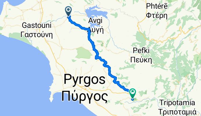
Limni Pineas - Patra Track Nr. 6
Trasa rowerowa w Synoikismós Chavaríou, Western Greece, Grecja
- 52,6 km
- Dystans
- 778 m
- Przewyższenia
- 851 m
- Spadek

Cycling Tour Pinios Lake & Elis Archeological Site
Trasa rowerowa w Synoikismós Chavaríou, Western Greece, Grecja
- 21,9 km
- Dystans
- 88 m
- Przewyższenia
- 219 m
- Spadek


Το Μονοπάτι της Εκεχειρίας - The Route of Truce
Trasa rowerowa w Synoikismós Chavaríou, Western Greece, Grecja
Οικοτουριστική Διαδρομή Ήλιδας - Ολυμπίας "Το Μονοπάτι της Εκεχειρίας" /
Eco-Touristic Route Ilis - Olympia "The Route of Truce"
Starting from Ancient Ilis, the “Route of Truce” crosses 13 semi-hilly villages of the Ilia Prefecture and Municipalities, Ilis (Dafni, Keramidia, Dafniotissa, Peristeri), Pyrgos (Chimadio, Sopi, Karatoulas, Magoula, Latzoi), Ancient Olympia (Iraklia, Pournari, Pelopio, Platanos), and ends in Ancient Olympia.
Through the “Route of Truce”, the visitors run along a route full of olive trees, vines, pomegranates, and herbs. Along the way, visitors will also be able to visit the towns of Ιlis and Olympia and learn more about the culture and the history of the area.
Through this project, we wish to raise awareness of the “Route of Truce,” inland Greece, and abroad in order to encourage tourism within the Elis hinterland.
- 49,8 km
- Dystans
- 588 m
- Przewyższenia
- 579 m
- Spadek