
Shipley na rowerze
Odkrywaj mapę z 80 trasami rowerowymi i szlakami w pobliżu Shipley, stworzonymi przez naszą społeczność.
Portret regionu
Poznaj Shipley
Znajdź odpowiednią trasę rowerową dla siebie w Shipley – mamy tam 80 tras do odkrycia. Większość osób wybiera się tutaj na rower w miesiącach Lipiec i Sierpień.
2737 km
Zarejestrowany dystans
80
Trasy rowerowe
28 544
Populacja
Wspólnota
Najaktywniejsi użytkownicy w Shipley


Starannie wybrane trasy
Odkryj Shipley dzięki tym kolekcjom

Od naszej społeczności
Najlepsze trasy rowerowe w Shipley i okolicach

Get miles
Trasa rowerowa w Shipley, Anglia, Zjednoczone Królestwo Wielkiej Brytanii
- 124,4 km
- Dystans
- 434 m
- Przewyższenia
- 514 m
- Spadek
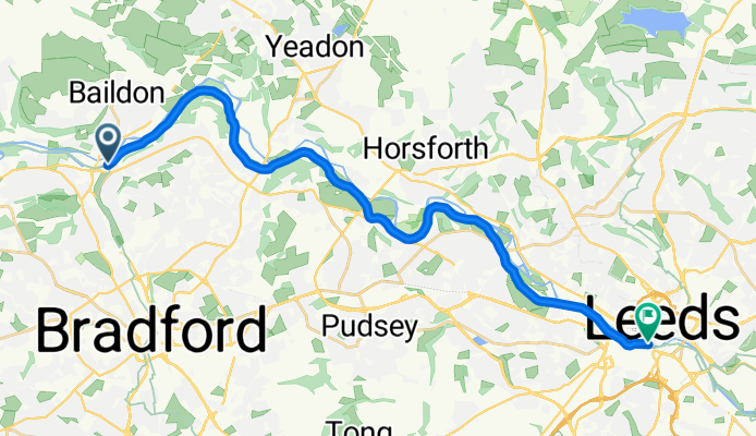
Shipley - Leeds
Trasa rowerowa w Shipley, Anglia, Zjednoczone Królestwo Wielkiej Brytanii
- 20,4 km
- Dystans
- 47 m
- Przewyższenia
- 87 m
- Spadek
Shipley - Leeds
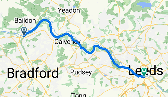
Trasa rowerowa w Shipley, Anglia, Zjednoczone Królestwo Wielkiej Brytanii
- 20,2 km
- Dystans
- 150 m
- Przewyższenia
- 190 m
- Spadek

Greengates/Skipton/Eccup loop
Trasa rowerowa w Shipley, Anglia, Zjednoczone Królestwo Wielkiej Brytanii
- 104,9 km
- Dystans
- 718 m
- Przewyższenia
- 720 m
- Spadek
Odkryj więcej tras
 The Moo-ers
- Dystans
- 31,8 km
- Przewyższenia
- 400 m
- Spadek
- 401 m
- Lokalizacja
- Shipley, Anglia, Zjednoczone Królestwo Wielkiej Brytanii
 Canal and moors
- Dystans
- 33,5 km
- Przewyższenia
- 329 m
- Spadek
- 329 m
- Lokalizacja
- Shipley, Anglia, Zjednoczone Królestwo Wielkiej Brytanii
 Apperley Bridge/Steeton loop
- Dystans
- 49,5 km
- Przewyższenia
- 353 m
- Spadek
- 385 m
- Lokalizacja
- Shipley, Anglia, Zjednoczone Królestwo Wielkiej Brytanii
 Greengates to Manjit's loop
- Dystans
- 28,3 km
- Przewyższenia
- 404 m
- Spadek
- 398 m
- Lokalizacja
- Shipley, Anglia, Zjednoczone Królestwo Wielkiej Brytanii
 East Morton & East Bradford
- Dystans
- 44,5 km
- Przewyższenia
- 451 m
- Spadek
- 449 m
- Lokalizacja
- Shipley, Anglia, Zjednoczone Królestwo Wielkiej Brytanii
 Loop around Bradford
- Dystans
- 48,3 km
- Przewyższenia
- 541 m
- Spadek
- 541 m
- Lokalizacja
- Shipley, Anglia, Zjednoczone Królestwo Wielkiej Brytanii
 Bumpy Wharfedale route
- Dystans
- 54,3 km
- Przewyższenia
- 612 m
- Spadek
- 612 m
- Lokalizacja
- Shipley, Anglia, Zjednoczone Królestwo Wielkiej Brytanii
 Greengates to Selby #2
- Dystans
- 115,8 km
- Przewyższenia
- 312 m
- Spadek
- 314 m
- Lokalizacja
- Shipley, Anglia, Zjednoczone Królestwo Wielkiej Brytanii