
Rochester na rowerze
Odkrywaj mapę z 46 trasami rowerowymi i szlakami w pobliżu Rochester, stworzonymi przez naszą społeczność.
Portret regionu
Poznaj Rochester
Znajdź odpowiednią trasę rowerową dla siebie w Rochester – mamy tam 46 tras do odkrycia.
2360 km
Zarejestrowany dystans
46
Trasy rowerowe
Wspólnota
Najaktywniejsi użytkownicy w Rochester


Od naszej społeczności
Najlepsze trasy rowerowe w Rochester i okolicach

Periple 11 / 28
Trasa rowerowa w Rochester, Anglia, Zjednoczone Królestwo Wielkiej Brytanii
- 167,7 km
- Dystans
- 1250 m
- Przewyższenia
- 1182 m
- Spadek

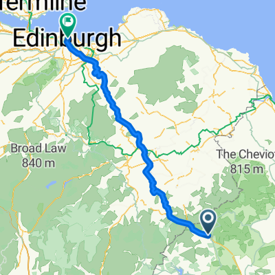
BfCiC recce
Trasa rowerowa w Rochester, Anglia, Zjednoczone Królestwo Wielkiej Brytanii
- 214,8 km
- Dystans
- 940 m
- Przewyższenia
- 1119 m
- Spadek

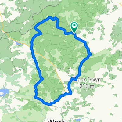
Kielder észak
Trasa rowerowa w Rochester, Anglia, Zjednoczone Królestwo Wielkiej Brytanii
- 17,1 km
- Dystans
- 178 m
- Przewyższenia
- 185 m
- Spadek

Kielder Water
Trasa rowerowa w Rochester, Anglia, Zjednoczone Królestwo Wielkiej Brytanii
- 48,4 km
- Dystans
- 444 m
- Przewyższenia
- 444 m
- Spadek
Odkryj więcej tras
 8 Otterburn Green, Newcastle Upon Tyne to Foundry Farm, Hexham
- Dystans
- 30,6 km
- Przewyższenia
- 363 m
- Spadek
- 465 m
- Lokalizacja
- Rochester, Anglia, Zjednoczone Królestwo Wielkiej Brytanii

Edge810®
Rochester Radfahren- Dystans
- 39,8 km
- Przewyższenia
- 514 m
- Spadek
- 512 m
- Lokalizacja
- Rochester, Anglia, Zjednoczone Królestwo Wielkiej Brytanii
 LEJOG - Day 10
- Dystans
- 112,6 km
- Przewyższenia
- 921 m
- Spadek
- 1112 m
- Lokalizacja
- Rochester, Anglia, Zjednoczone Królestwo Wielkiej Brytanii

Edge810®
Rochester Cycling- Dystans
- 9,7 km
- Przewyższenia
- 161 m
- Spadek
- 155 m
- Lokalizacja
- Rochester, Anglia, Zjednoczone Królestwo Wielkiej Brytanii

Edge810®
Rochester Cycling- Dystans
- 40,1 km
- Przewyższenia
- 519 m
- Spadek
- 522 m
- Lokalizacja
- Rochester, Anglia, Zjednoczone Królestwo Wielkiej Brytanii
 Lew and Cal round Kielder
- Dystans
- 41,6 km
- Przewyższenia
- 253 m
- Spadek
- 253 m
- Lokalizacja
- Rochester, Anglia, Zjednoczone Królestwo Wielkiej Brytanii
 Pt9 THE FINAL DAY
- Dystans
- 93,5 km
- Przewyższenia
- 509 m
- Spadek
- 675 m
- Lokalizacja
- Rochester, Anglia, Zjednoczone Królestwo Wielkiej Brytanii
 wild camping weekend
- Dystans
- 89,9 km
- Przewyższenia
- 872 m
- Spadek
- 872 m
- Lokalizacja
- Rochester, Anglia, Zjednoczone Królestwo Wielkiej Brytanii