
Attinghausen na rowerze
Odkrywaj mapę z 42 trasami rowerowymi i szlakami w pobliżu Attinghausen, stworzonymi przez naszą społeczność.
Portret regionu
Poznaj Attinghausen
Znajdź odpowiednią trasę rowerową dla siebie w Attinghausen – mamy tam 42 tras do odkrycia.
2154 km
Zarejestrowany dystans
42
Trasy rowerowe
1515
Populacja
Wspólnota
Najaktywniejsi użytkownicy w Attinghausen


Starannie wybrane trasy
Odkryj Attinghausen dzięki tym kolekcjom
Wycieczka
Od naszej społeczności
Najlepsze trasy rowerowe w Attinghausen i okolicach
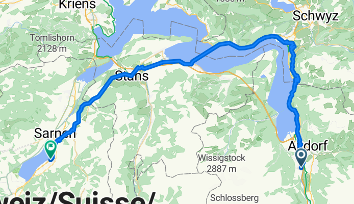
V2_E03_ALPX_Schweiz
Trasa rowerowa w Attinghausen, Uri, Szwajcaria
- 60,3 km
- Dystans
- 1597 m
- Przewyższenia
- 1602 m
- Spadek

Attinghausen - Erstfeld- Attingh.
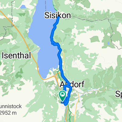
Trasa rowerowa w Attinghausen, Uri, Szwajcaria
- 10,8 km
- Dystans
- 284 m
- Przewyższenia
- 279 m
- Spadek

Schattdorf-Andermatt
Trasa rowerowa w Attinghausen, Uri, Szwajcaria
- 35,5 km
- Dystans
- 1043 m
- Przewyższenia
- 84 m
- Spadek

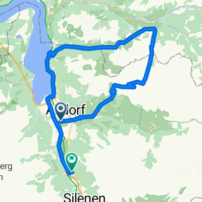
Attinghausen-Brüsti-Attinghausen
Trasa rowerowa w Attinghausen, Uri, Szwajcaria
- 18,2 km
- Dystans
- 1319 m
- Przewyższenia
- 1320 m
- Spadek
Odkryj więcej tras
 Attinghausen-Ribi-Urigen-Alp_Selez-Eggberge-Attinghausen
- Dystans
- 43,6 km
- Przewyższenia
- 1638 m
- Spadek
- 1636 m
- Lokalizacja
- Attinghausen, Uri, Szwajcaria
 Obere Postmatte 1, Attinghausen to Obere Postmatte 1, Attinghausen
- Dystans
- 26,1 km
- Przewyższenia
- 397 m
- Spadek
- 385 m
- Lokalizacja
- Attinghausen, Uri, Szwajcaria
 A2, Schattdorf nach A2, Schattdorf
- Dystans
- 0,1 km
- Przewyższenia
- 0 m
- Spadek
- 0 m
- Lokalizacja
- Attinghausen, Uri, Szwajcaria
 Attinghausen-Klauenpass-Eggberge-Attinghausen
- Dystans
- 58,9 km
- Przewyższenia
- 2242 m
- Spadek
- 2240 m
- Lokalizacja
- Attinghausen, Uri, Szwajcaria
 Gitschital
- Dystans
- 10,3 km
- Przewyższenia
- 935 m
- Spadek
- 142 m
- Lokalizacja
- Attinghausen, Uri, Szwajcaria
 Surenenpass-Erstfeld
- Dystans
- 11,6 km
- Przewyższenia
- 77 m
- Spadek
- 1881 m
- Lokalizacja
- Attinghausen, Uri, Szwajcaria
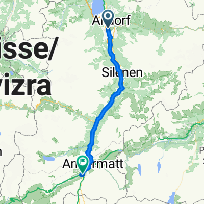 Attinghausen - Andermatt
- Dystans
- 36,9 km
- Przewyższenia
- 1813 m
- Spadek
- 745 m
- Lokalizacja
- Attinghausen, Uri, Szwajcaria
 Altdorf- Kinzig-Muothatal-Erstfeld
- Dystans
- 50,3 km
- Przewyższenia
- 2420 m
- Spadek
- 2399 m
- Lokalizacja
- Attinghausen, Uri, Szwajcaria