
Sermaize-les-Bains na rowerze
Odkrywaj mapę z 4 trasami rowerowymi i szlakami w pobliżu Sermaize-les-Bains, stworzonymi przez naszą społeczność.
Bądź pionierem
Zainspiruj innych rowerzystów swoją trasą w Sermaize-les-Bains
Bikemap to globalna społeczność rowerowa z milionami tras tworzonych przez rowerzystów takich jak Ty. W Sermaize-les-Bains jest na razie tylko kilka tras, więc narysuj swoje ulubione przejazdy na mapie, by pomóc innym odkryć najlepsze trasy.
Od naszej społeczności
Najlepsze trasy rowerowe w Sermaize-les-Bains i okolicach

Recovered Route
Trasa rowerowa w Sermaize-les-Bains, Grand Est, Francja
- 4,1 km
- Dystans
- 16 m
- Przewyższenia
- 3 m
- Spadek
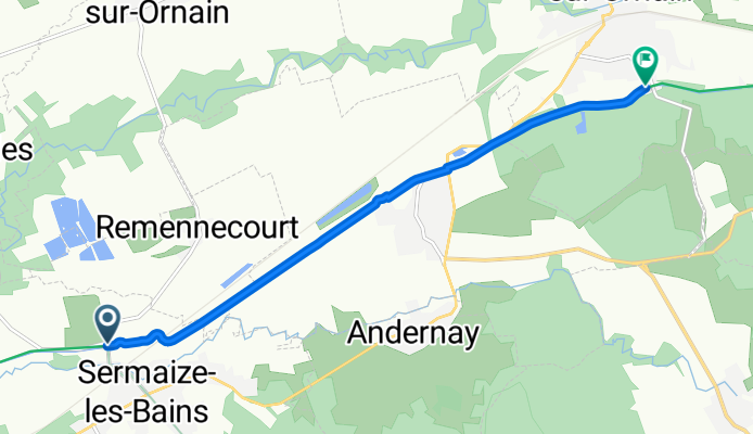
Voie Verte de la Vallée de l’Ornain
Trasa rowerowa w Sermaize-les-Bains, Grand Est, Francja
Roll out of Sermaize-les-Bains and cruise the Voie Verte de la Vallée de l’Ornain to Revigny-sur-Ornain. About 7 km on a smooth, traffic-free path, mostly flat with a gentle rise—easy for any rider. Expect calm river views, open fields, and plenty of fresh air. Perfect for a quick spin or family outing, with amenities in both towns when you’re done.
- 7,2 km
- Dystans
- 45 m
- Przewyższenia
- 17 m
- Spadek
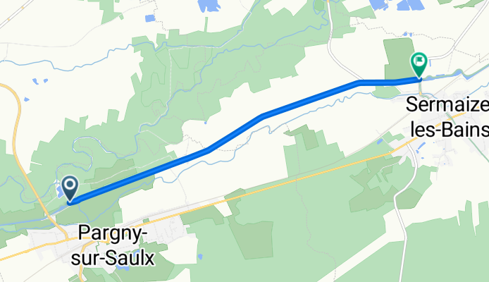
Véloroute 52: Sermaize-les-Bains to Pargny-sur-Saulx
Trasa rowerowa w Sermaize-les-Bains, Grand Est, Francja
Easy, flat 5.4 km spin linking two Saulx-side villages on the Paneuropa Route. Roll out of Sermaize-les-Bains and follow quiet access roads toward Pargny-sur-Saulx, with barely a bump (about 11 m up). Nice for a warm-up or a family ride, with chances to pause by the river and in village centers. Wayfinding is straightforward—follow V52 signs where posted.
- 5,4 km
- Dystans
- 11 m
- Przewyższenia
- 0 m
- Spadek
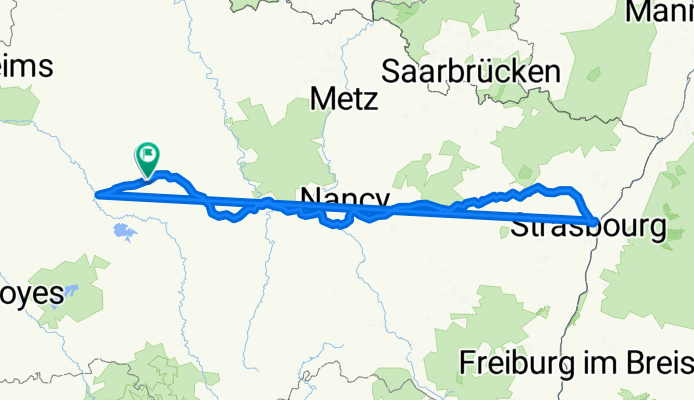
Robertsau - Vitry le François
Trasa rowerowa w Sermaize-les-Bains, Grand Est, Francja
Long du canal de Marne au Rhin
- 309,5 km
- Dystans
- 486 m
- Przewyższenia
- 489 m
- Spadek