
Salernes na rowerze
Odkrywaj mapę z 95 trasami rowerowymi i szlakami w pobliżu Salernes, stworzonymi przez naszą społeczność.
Portret regionu
Poznaj Salernes
Znajdź odpowiednią trasę rowerową dla siebie w Salernes – mamy tam 95 tras do odkrycia. Większość osób wybiera się tutaj na rower w miesiącach Czerwiec i Lipiec.
6209 km
Zarejestrowany dystans
95
Trasy rowerowe
3673
Populacja
Wspólnota
Najaktywniejsi użytkownicy w Salernes


Od naszej społeczności
Najlepsze trasy rowerowe w Salernes i okolicach
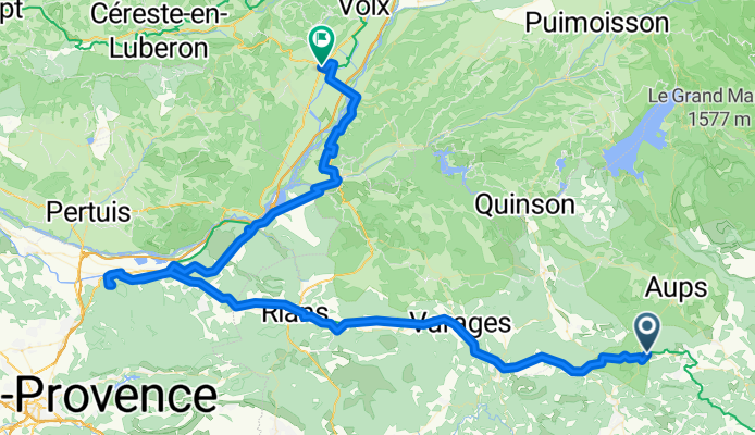
Sillans La Cascade - Manosque
Trasa rowerowa w Salernes, Prowansja-Alpy-Lazurowe Wybrzeże, Francja
- 117,2 km
- Dystans
- 1419 m
- Przewyższenia
- 1458 m
- Spadek

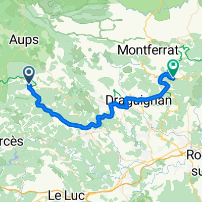
Tour of Central Var
Trasa rowerowa w Salernes, Prowansja-Alpy-Lazurowe Wybrzeże, Francja
- 67,7 km
- Dystans
- 688 m
- Przewyższenia
- 679 m
- Spadek

Beauty in the Valley
Trasa rowerowa w Salernes, Prowansja-Alpy-Lazurowe Wybrzeże, Francja
- 43 km
- Dystans
- 366 m
- Przewyższenia
- 366 m
- Spadek

Fun & Quick
Trasa rowerowa w Salernes, Prowansja-Alpy-Lazurowe Wybrzeże, Francja
- 40,9 km
- Dystans
- 388 m
- Przewyższenia
- 388 m
- Spadek
Odkryj więcej tras
 70km,1200hm
- Dystans
- 69,2 km
- Przewyższenia
- 1080 m
- Spadek
- 1081 m
- Lokalizacja
- Salernes, Prowansja-Alpy-Lazurowe Wybrzeże, Francja
 30km,400hm
- Dystans
- 29,2 km
- Przewyższenia
- 469 m
- Spadek
- 475 m
- Lokalizacja
- Salernes, Prowansja-Alpy-Lazurowe Wybrzeże, Francja
 Cours Théodore Bouge, Salernes à Route Departementale, Callas
- Dystans
- 42,7 km
- Przewyższenia
- 840 m
- Spadek
- 766 m
- Lokalizacja
- Salernes, Prowansja-Alpy-Lazurowe Wybrzeże, Francja
 Seillans/Seillans
- Dystans
- 58 km
- Przewyższenia
- 487 m
- Spadek
- 471 m
- Lokalizacja
- Salernes, Prowansja-Alpy-Lazurowe Wybrzeże, Francja
 Salernes-La Roque-d'Anthéron
- Dystans
- 86,6 km
- Przewyższenia
- 769 m
- Spadek
- 834 m
- Lokalizacja
- Salernes, Prowansja-Alpy-Lazurowe Wybrzeże, Francja
 WE LORGUES 83KM 1400D+
- Dystans
- 83 km
- Przewyższenia
- 1162 m
- Spadek
- 1164 m
- Lokalizacja
- Salernes, Prowansja-Alpy-Lazurowe Wybrzeże, Francja
 Tour of Central Var CLONED FROM ROUTE 127751
- Dystans
- 67,8 km
- Przewyższenia
- 428 m
- Spadek
- 428 m
- Lokalizacja
- Salernes, Prowansja-Alpy-Lazurowe Wybrzeże, Francja
 Tour of Central Var
- Dystans
- 67,8 km
- Przewyższenia
- 382 m
- Spadek
- 382 m
- Lokalizacja
- Salernes, Prowansja-Alpy-Lazurowe Wybrzeże, Francja