
Riom-ès-Montagnes na rowerze
Odkrywaj mapę z 70 trasami rowerowymi i szlakami w pobliżu Riom-ès-Montagnes, stworzonymi przez naszą społeczność.
Portret regionu
Poznaj Riom-ès-Montagnes
Znajdź odpowiednią trasę rowerową dla siebie w Riom-ès-Montagnes – mamy tam 70 tras do odkrycia. Większość osób wybiera się tutaj na rower w miesiącach Maj i Lipiec.
5718 km
Zarejestrowany dystans
70
Trasy rowerowe
2902
Populacja
Wspólnota
Najaktywniejsi użytkownicy w Riom-ès-Montagnes


Od naszej społeczności
Najlepsze trasy rowerowe w Riom-ès-Montagnes i okolicach


2019-26 Riom-ès-Montagnes to Aurillac
Trasa rowerowa w Riom-ès-Montagnes, Owernia-Rodan-Alpy, Francja
In 2019, we did self-supported touring for a little less than 2 months from mid-September through early November.
Day 26 - Riom-ès-Montagnes to Aurillac
The ride on D3 was beautiful despite it’s being a relatively major road. Traffic was sparse and we enjoyed the ups and downs. The climb to the Col d’Entremont (1210M) was relatively benign from this direction, with the slope being pretty gentle.
Arriving at D139, which hits D3 several kilometers before Murat, we turned in and found a beautiful road that connected south to Laveissière and a road (D439) that runs parallel to N122.
At Fraisse-Haut, which is just a little west of Laveissière on D439, we found an unnumbered side road that paralleled N122 for a number of kilometers. Taking this narrow single lane chaussée-deformée (but fortunately paved) road, we had a beautiful but very very challenging climb that took us up past a railway bridge and eventually back to N122, not far from the Tunnel du Lioran. I think this was the first time this trip that I actually used my lowest gear on my touring bicycle. We did not try to go through the tunnel (probably it is prohibited for cyclists) and instead climbed further on D67 to the Col de Cère at 1294M, passing several ski areas as we climbed. We had planned to use other smaller side roads after the Col de Cère to avoid being on N122 for much of the remaining mileage to Aurillac, but this climb starting from Fraisse-Haut had been so tough that we figured we’d have to stay on N122 to make sure that we’d get to Aurillac before dark. (Due to last night's time change because of the end of daylight savings time, I think we both through that we had one less hour of daylight remaining. I had not changed the time on our bicycle computers.) In any case, with a few exceptions, most of the remaining ride to Aurillac was downhill, with the first kilometers after rejoining N122 from D67 being a heck of a downhill run. Overall, N122 wasn’t bad as the scenery is great and there wasn’t much traffic until getting within ten kilometers or so of Aurillac. It also occasionally had some road shoulder. We arrived in Aurillac about two hours before sunset, so no problem on timing.
- 84,9 km
- Dystans
- 1008 m
- Przewyższenia
- 1223 m
- Spadek

4.etapa Riom-es-Montagnes - Saint-Cirgues-De-Jordanne
Trasa rowerowa w Riom-ès-Montagnes, Owernia-Rodan-Alpy, Francja
<span style="font-size: 11pt; line-height: 115%; font-family: "Calibri", "sans-serif";">Kemp v Saint-Cirgues-De-Jordann</span>
Původně jsme měli být v kempu hned po sjezdu z Puy Mary,
ale jediný kemp byl zavřený. Nakonec nám místní sehnali kemp v Saint-Cirgues-De-Jordanne
cca 8 km od původního kempu po toku řeky. Je lokalizován na dosti strmém
stoupání (závěr etapy byl vskutku výživný...) Jedná se pravděpodobně o usedlost
spojenou s malou farmou (dál cesta odtud již nevede - je tu božský klid). 2
sprchy v přízemí, 2 sprchy v 1.patře. Elektrika + teplá voda + WC bez problému,
internet není k dispozici. Jako první kemp má toaletu vybavenou toaletním
papírem. Kapacitu kempu bych odhadoval na cca 12 stanů.
cca 6,30 Euro / osoba
Údaje z cyklocomputeru:<br />trasa 65,80 km / nastoupáno 1281 metrů / 3:30:35 hod
- 84,3 km
- Dystans
- 1474 m
- Przewyższenia
- 1454 m
- Spadek

Trip vélo Cantal - Corrèze 2011
Trasa rowerowa w Riom-ès-Montagnes, Owernia-Rodan-Alpy, Francja
- 299,2 km
- Dystans
- 2021 m
- Przewyższenia
- 2021 m
- Spadek

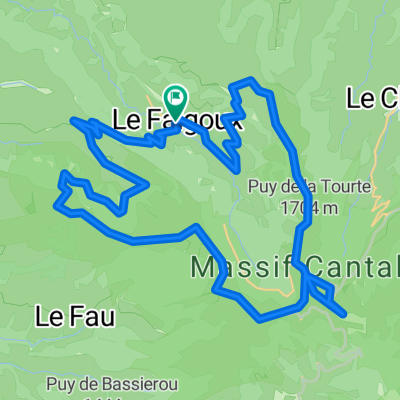
Cantal 2022 N° 2 bis 103km 2110 D+
Trasa rowerowa w Riom-ès-Montagnes, Owernia-Rodan-Alpy, Francja
le falgoux-puy marie-D 17 dir aurillac-st Simon-rte des crêtes-Cheules-Houde-le Bruel-st georges-le fau-salers-le falgoux
- 103 km
- Dystans
- 2461 m
- Przewyższenia
- 2469 m
- Spadek
Odkryj więcej tras
 Cantal 2022 N°1 bis 61km
- Dystans
- 60,9 km
- Przewyższenia
- 1396 m
- Spadek
- 1397 m
- Lokalizacja
- Riom-ès-Montagnes, Owernia-Rodan-Alpy, Francja
 Cantal 2022 circuit N°1 - 43km samedi aprem
- Dystans
- 43,2 km
- Przewyższenia
- 951 m
- Spadek
- 954 m
- Lokalizacja
- Riom-ès-Montagnes, Owernia-Rodan-Alpy, Francja
 Cantal 2022 N°XL157km 3400D+
- Dystans
- 156,9 km
- Przewyższenia
- 3928 m
- Spadek
- 3928 m
- Lokalizacja
- Riom-ès-Montagnes, Owernia-Rodan-Alpy, Francja
 Cantal 2022 N°2 80km 1580D+
- Dystans
- 80,1 km
- Przewyższenia
- 1648 m
- Spadek
- 1646 m
- Lokalizacja
- Riom-ès-Montagnes, Owernia-Rodan-Alpy, Francja
 Cantal2022 N°3 104km 2400 D+
- Dystans
- 103,6 km
- Przewyższenia
- 2418 m
- Spadek
- 2416 m
- Lokalizacja
- Riom-ès-Montagnes, Owernia-Rodan-Alpy, Francja
 Le Puy Mary (1783m) et la vallée du Falgoux par les crêtes
- Dystans
- 43,9 km
- Przewyższenia
- 1933 m
- Spadek
- 1934 m
- Lokalizacja
- Riom-ès-Montagnes, Owernia-Rodan-Alpy, Francja
 Plateau de Trizac -1568-Utagawa
- Dystans
- 40 km
- Przewyższenia
- 946 m
- Spadek
- 948 m
- Lokalizacja
- Riom-ès-Montagnes, Owernia-Rodan-Alpy, Francja
 12. Etappe: Condat über Pas de Peyrol
- Dystans
- 52,6 km
- Przewyższenia
- 1064 m
- Spadek
- 1154 m
- Lokalizacja
- Riom-ès-Montagnes, Owernia-Rodan-Alpy, Francja