
Ornaisons na rowerze
Odkrywaj mapę z 13 trasami rowerowymi i szlakami w pobliżu Ornaisons, stworzonymi przez naszą społeczność.
Portret regionu
Poznaj Ornaisons
Znajdź odpowiednią trasę rowerową dla siebie w Ornaisons – mamy tam 13 tras do odkrycia.
879 km
Zarejestrowany dystans
13
Trasy rowerowe
1146
Populacja
Wspólnota
Najaktywniejsi użytkownicy w Ornaisons

Od naszej społeczności
Najlepsze trasy rowerowe w Ornaisons i okolicach

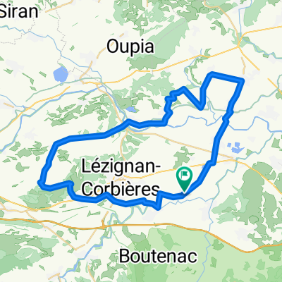
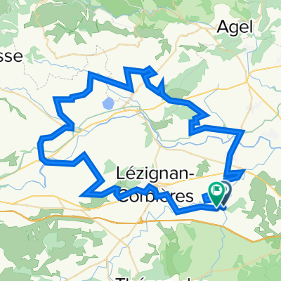
Ornaisons 3a
Trasa rowerowa w Ornaisons, Occitanie, Francja
Tramontane (wind) from the NW is the biggest problem in this area. There is one steep pull up to Villerouge-la -Cremade but a nice long run down the other side as a reward. Mostly through vineyards and quiet villages. one short stretch on a busier road just after Thezans. Some of the tarmac roads along the back stretches uneven in places but no major potholes.
(cloned from route 3101334)
- 37,6 km
- Dystans
- 162 m
- Przewyższenia
- 154 m
- Spadek

18 septembre 2011 - Corbières secrètes
Trasa rowerowa w Ornaisons, Occitanie, Francja
<span style="color: #000000;"><font face="Times New Roman, serif"><font style="font-size: 16pt;" size="4">Corbières
secrètes 120 km</font></font></span>
<span style="color: #000000;"><font face="Times New Roman, serif"><font style="font-size: 16pt;" size="4">Dimanche
18 septembre 2011</font></font></span>
<span style="color: #000000;"><font face="Times New Roman, serif"><font style="font-size: 16pt;" size="4">Rdv
au bar face à la Mairie d’Ornaisons et son parking. </font></font></span>
<span style="color: #000000;"> <span lang="fr-FR"><font style="font-size: 16pt;" size="4"><font face="Times New Roman, serif">Départ
à 8h15 / repas tiré du sac</font></font></span></span>
<span style="color: #000000;"><font face="Times New Roman, serif"><font style="font-size: 16pt;" size="4">A9
sortie 38 Narbonne Sud suivre la D6009, D6113 en direction de
Carcassonne et Lézignan, puis la D24 à gauche pour
Ornaisons</font></font></span>
<span lang="fr-FR"><span style="font-size: medium;"><font face="Times New Roman, serif"><font color="#000000">Ornaisons.
D123. Boutenac. Ferrals les Corbières. D106. Villerouge la
Cremade. CV droite. D611 à gauche. D613. Saint
Laurent de Cabrerisse (1). CV. Rabet Montjoi. D106. Coustouge
(2). D106 col de Rouire 304m. D40. Col de l’Escassié
287m. Albas (3). Cascatel des Corbières. Quintillan
(4). D12. Col d’Amiel 378m. Col de la Gineste 416m. Palairac.
Col de Ferreol 428m. D39. Col de Couisse 507m. Félines
Termenès. Col de la Tranchée 372 m. Villerouge
Termenès (5). Col de Villerouge 404m. D23. Lagrasse
(6). D212. Ribaute . Fabrezan. Ferrals les Corbières.
D161. D261. Luc sur Orbieu. Ornaisons. </font></font></span></span>
- 112,1 km
- Dystans
- 963 m
- Przewyższenia
- 963 m
- Spadek
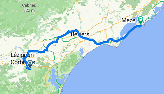
France 7 - Lezignan - Sète
Trasa rowerowa w Ornaisons, Occitanie, Francja
- 110 km
- Dystans
- 394 m
- Przewyższenia
- 459 m
- Spadek
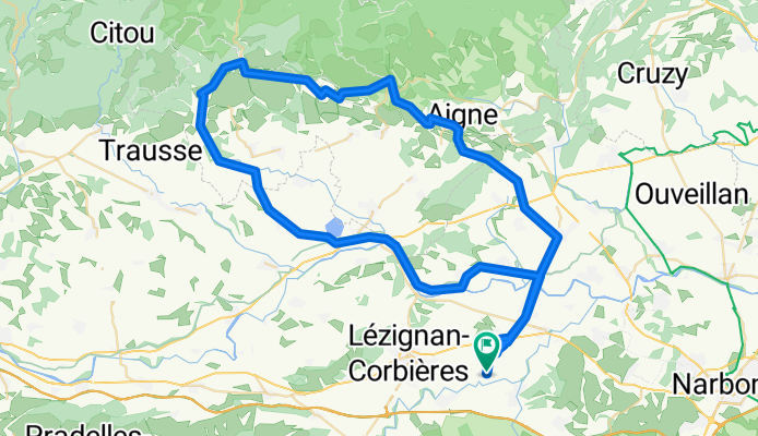
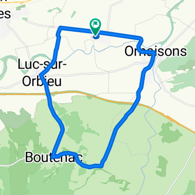
Cruscades Tag 3 - 82
Trasa rowerowa w Ornaisons, Occitanie, Francja
- 82,6 km
- Dystans
- 505 m
- Przewyższenia
- 505 m
- Spadek
Odkryj więcej tras
 Cruscades Tag 7 - 62
- Dystans
- 62,8 km
- Przewyższenia
- 315 m
- Spadek
- 318 m
- Lokalizacja
- Ornaisons, Occitanie, Francja
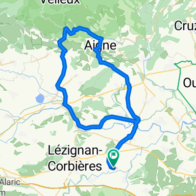
 Cruscades Tag 4 - Tandem 58
- Dystans
- 58,1 km
- Przewyższenia
- 312 m
- Spadek
- 312 m
- Lokalizacja
- Ornaisons, Occitanie, Francja
 Fontjoncouse90
- Dystans
- 90,6 km
- Przewyższenia
- 836 m
- Spadek
- 836 m
- Lokalizacja
- Ornaisons, Occitanie, Francja
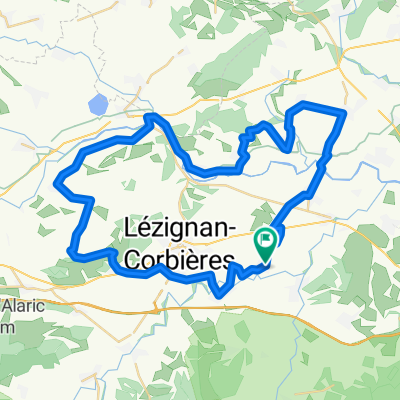
 Cruscades Tour 1 - 48
- Dystans
- 48,1 km
- Przewyższenia
- 324 m
- Spadek
- 327 m
- Lokalizacja
- Ornaisons, Occitanie, Francja
 Cruscades Tag 5 - 69
- Dystans
- 69,1 km
- Przewyższenia
- 402 m
- Spadek
- 407 m
- Lokalizacja
- Ornaisons, Occitanie, Francja
 De 8 Rue de l'Aramon, Cruscades à 8 Rue de l'Aramon, Cruscades
- Dystans
- 17,7 km
- Przewyższenia
- 102 m
- Spadek
- 101 m
- Lokalizacja
- Ornaisons, Occitanie, Francja
 Pfingsturlaub Tour 2 Tandem
- Dystans
- 50,3 km
- Przewyższenia
- 304 m
- Spadek
- 304 m
- Lokalizacja
- Ornaisons, Occitanie, Francja
 Ornaisons83
- Dystans
- 82,4 km
- Przewyższenia
- 591 m
- Spadek
- 592 m
- Lokalizacja
- Ornaisons, Occitanie, Francja