
Gond-Pontouvre na rowerze
Odkrywaj mapę z 41 trasami rowerowymi i szlakami w pobliżu Gond-Pontouvre, stworzonymi przez naszą społeczność.
Portret regionu
Poznaj Gond-Pontouvre
Znajdź odpowiednią trasę rowerową dla siebie w Gond-Pontouvre – mamy tam 41 tras do odkrycia. Większość osób wybiera się tutaj na rower w miesiącu Lipiec.
1411 km
Zarejestrowany dystans
41
Trasy rowerowe
6218
Populacja
Wspólnota
Najaktywniejsi użytkownicy w Gond-Pontouvre


Od naszej społeczności
Najlepsze trasy rowerowe w Gond-Pontouvre i okolicach

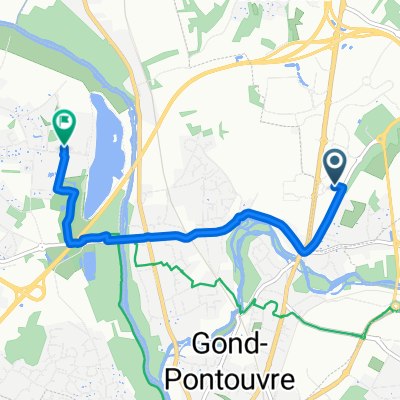
Jonction (Saint-Yrieix-sur-Charente >< Angoulême)
Trasa rowerowa w Gond-Pontouvre, Nouvelle-Aquitaine, Francja
(Camping du Plan d'eau >< Angoulême centre - Champ de Mars)
- 7,3 km
- Dystans
- 65 m
- Przewyższenia
- 16 m
- Spadek

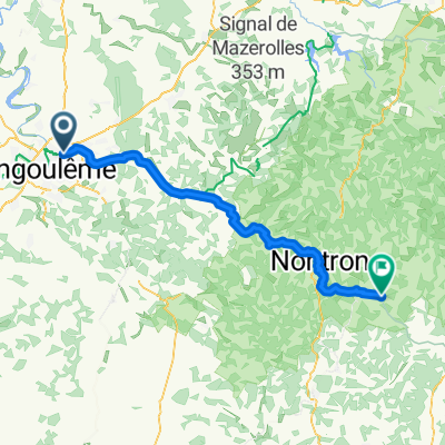
Tour de Base - Étape 8 (Saint-Yrieix-sur-Charente > Saint-Félix-de-Bourdeilles, via La Flow Vélo)
Trasa rowerowa w Gond-Pontouvre, Nouvelle-Aquitaine, Francja
Saint-Yrieix-sur-Charente > Saint-Félix-de-Bourdeilles
Hébergement le soir au camping Domaine des Etangs du Plessac, Le Bourg, 24340 Saint-Félix-de-Bourdeilles 05 53 46 39 12
- 65,1 km
- Dystans
- 428 m
- Przewyższenia
- 302 m
- Spadek

De Rue du Camping 1, Saint-Yrieix-sur-Charente à Impasse Chaussée des Moulins 3, Jarnac
Trasa rowerowa w Gond-Pontouvre, Nouvelle-Aquitaine, Francja
- 42 km
- Dystans
- 237 m
- Przewyższenia
- 255 m
- Spadek

Cha-Landak 1
Trasa rowerowa w Gond-Pontouvre, Nouvelle-Aquitaine, Francja
- 34,5 km
- Dystans
- 101 m
- Przewyższenia
- 114 m
- Spadek
Odkryj więcej tras
 5. Angouleme to Sarlat
- Dystans
- 161,2 km
- Przewyższenia
- 1042 m
- Spadek
- 944 m
- Lokalizacja
- Gond-Pontouvre, Nouvelle-Aquitaine, Francja
 De Rue Alfred Leyssenot 39, Gond-Pontouvre à Rue Alfred Leyssenot 39, Gond-Pontouvre
- Dystans
- 22,5 km
- Przewyższenia
- 128 m
- Spadek
- 127 m
- Lokalizacja
- Gond-Pontouvre, Nouvelle-Aquitaine, Francja
 268 Route de Vars, Gond-Pontouvre à 1 Rue de la Rivière, Gond-Pontouvre
- Dystans
- 19,3 km
- Przewyższenia
- 158 m
- Spadek
- 156 m
- Lokalizacja
- Gond-Pontouvre, Nouvelle-Aquitaine, Francja
 De 325 Route de Vars, Gond-Pontouvre à 2 Rue des Courly, Balzac
- Dystans
- 3,1 km
- Przewyższenia
- 33 m
- Spadek
- 7 m
- Lokalizacja
- Gond-Pontouvre, Nouvelle-Aquitaine, Francja
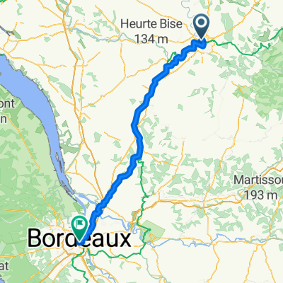 Bordeaux1
- Dystans
- 147,3 km
- Przewyższenia
- 869 m
- Spadek
- 893 m
- Lokalizacja
- Gond-Pontouvre, Nouvelle-Aquitaine, Francja
 Gond-Pontouvre - Sent Pardol de la Ribiera
- Dystans
- 66,4 km
- Przewyższenia
- 725 m
- Spadek
- 582 m
- Lokalizacja
- Gond-Pontouvre, Nouvelle-Aquitaine, Francja
 13b-Angouleme-C-Nizour
- Dystans
- 19,9 km
- Przewyższenia
- 143 m
- Spadek
- 153 m
- Lokalizacja
- Gond-Pontouvre, Nouvelle-Aquitaine, Francja
 Rue du Linteau, Champniers nach Rue du Camping, Saint-Yrieix-sur-Charente
- Dystans
- 4,9 km
- Przewyższenia
- 39 m
- Spadek
- 81 m
- Lokalizacja
- Gond-Pontouvre, Nouvelle-Aquitaine, Francja