
La Peyratte na rowerze
Odkrywaj mapę z 9 trasami rowerowymi i szlakami w pobliżu La Peyratte, stworzonymi przez naszą społeczność.
Portret regionu
Poznaj La Peyratte
Znajdź odpowiednią trasę rowerową dla siebie w La Peyratte – mamy tam 9 tras do odkrycia.
1019 km
Zarejestrowany dystans
9
Trasy rowerowe
1187
Populacja
Wspólnota
Najaktywniejsi użytkownicy w La Peyratte


Od naszej społeczności
Najlepsze trasy rowerowe w La Peyratte i okolicach
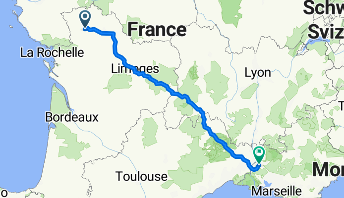
La Roucherie to Chemin de la Croix du Vigneron
Trasa rowerowa w La Peyratte, Nouvelle-Aquitaine, Francja
- 765,5 km
- Dystans
- 14 442 m
- Przewyższenia
- 14 508 m
- Spadek


De Rue de Fumaille, La Peyratte à Allée des Pêcheurs 731, Argenton-l'Église
Trasa rowerowa w La Peyratte, Nouvelle-Aquitaine, Francja
- 78 km
- Dystans
- 796 m
- Przewyższenia
- 861 m
- Spadek

Steady ride in Parthenay
Trasa rowerowa w La Peyratte, Nouvelle-Aquitaine, Francja
- 11,1 km
- Dystans
- 195 m
- Przewyższenia
- 175 m
- Spadek

De 12 Rue de la Guinière, Aubigny à 121 Route de Pont-Soutain, Pompaire
Trasa rowerowa w La Peyratte, Nouvelle-Aquitaine, Francja
- 27,4 km
- Dystans
- 458 m
- Przewyższenia
- 452 m
- Spadek
Odkryj więcej tras
 Naar de bakker bij gite Les jardins du Gue
- Dystans
- 14,4 km
- Przewyższenia
- 114 m
- Spadek
- 115 m
- Lokalizacja
- La Peyratte, Nouvelle-Aquitaine, Francja
 Route naar Rue du Général d'Autichamp 6, Lhoumois
- Dystans
- 44,4 km
- Przewyższenia
- 356 m
- Spadek
- 356 m
- Lokalizacja
- La Peyratte, Nouvelle-Aquitaine, Francja
 La Roucherie to Place Charles de Gaulle
- Dystans
- 62,1 km
- Przewyższenia
- 1911 m
- Spadek
- 1970 m
- Lokalizacja
- La Peyratte, Nouvelle-Aquitaine, Francja
 Itinéraire vers 11 Rue de la Mairie, La Ferrière-en-Parthenay
- Dystans
- 10,7 km
- Przewyższenia
- 75 m
- Spadek
- 30 m
- Lokalizacja
- La Peyratte, Nouvelle-Aquitaine, Francja
 2 Saint-Jacques des Rivières, La Peyratte nach D165, La Peyratte
- Dystans
- 5,2 km
- Przewyższenia
- 54 m
- Spadek
- 60 m
- Lokalizacja
- La Peyratte, Nouvelle-Aquitaine, Francja