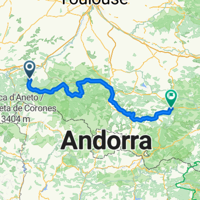
Aspet na rowerze
Odkrywaj mapę z 215 trasami rowerowymi i szlakami w pobliżu Aspet, stworzonymi przez naszą społeczność.
Portret regionu
Poznaj Aspet
Znajdź odpowiednią trasę rowerową dla siebie w Aspet – mamy tam 215 tras do odkrycia. Większość osób wybiera się tutaj na rower w miesiącach Czerwiec i Lipiec.
18 831 km
Zarejestrowany dystans
215
Trasy rowerowe
1154
Populacja
Od naszej społeczności
Najlepsze trasy rowerowe w Aspet i okolicach
Ride Day 14—24 Sept 2005—09800 Saint-Lary to 09000 Col des Marrous – Le Bosc – Foix
Trasa rowerowa w Aspet, Languedoc-Roussillon-Midi-Pyrénées, France
<span style="font-size: 12pt; font-family: Arial;">Today’s ride, which had
plenty of solid climbing, was entirely within the Parc Naturel Régional des
Pyrénées Ariégeoises.</span> <span style="font-size: 12pt; font-family: Arial;"><span> </span>Starting from
Saint Lary at 692 M, we descended to St Girons at about 400 M.<span> </span>From there we climbed through various
cols to 1465 M and then descended to our stopping point for the evening at 990
M.<span> </span>Along the way, we passed
through the following cols:</span>
<span style="font-size: 12pt; font-family: Arial;">Col de Crouzette at 1241 M</span>
<span style="font-size: 12pt; font-family: Arial;">Col
du Portel at 1465 M</span>
<span style="font-size: 12pt; font-family: Arial;">Col de Péguère at 1375 M</span>
<span style="font-size: 12pt; font-family: Arial;">Col de Jouels at 1247 M</span>
<span style="font-size: 12pt; font-family: Arial;">Col de
Marrous at 990 M</span>
<span style="font-size: 12pt; font-family: Arial;">Going from west to east
gave us some very steep climbing up to the first col.<span> </span>Four years previously in 2001, we did this same climb but
east to west…and the slopes for the bulk of the climb along D17 from Foix were
a lot gentler.</span>
<span style="font-size: 12pt; font-family: Arial;">D18 was a very narrow road
with the steepest climbing and fortunately only six cars passed by while we
were struggling up…and that was six cars too many.<span> </span>Lower down the climb when we’d been on D3 before we got near
Rivèrenet on D33, there had been a steady stream of cars that had us a bit
worried.</span>
<span style="font-size: 12pt; font-family: Arial;">During the climb and
especially between the first three cols, the views were spectacular.<span> </span>It felt like being on top of the
world.<span> </span>I recall that four years
ago when we arrived at the Col de Péguère and the orientation table that’s
there, it was foggy and we couldn’t see any of the view.</span>
Background:<br /><br /><br />My wife and I have been doing self-supported tours in Western Europe (a majority in France) since 1993. This series of rides covers our 2005 2 month route through parts of France. Our beginning and ending point is near Chaduri (south of Angoulême) where our friends have a farm with Gites and Chambres d'Hotes.<br /><br /><br />We rode our Dawes touring bicycles purchased in 1993 heavily loaded with 700Cx32 tires. All of our riding was on paved roads, mostly with very little traffic.<br /><br /><br />If any questions, feel free to email me at jeffkadet@netdiving.com<br /><br /><br />Jeff
- 62,7 km
- Dystans
- 1118 m
- Przewyższenia
- 809 m
- Spadek
2012 T5
Trasa rowerowa w Aspet, Languedoc-Roussillon-Midi-Pyrénées, France
<span class="location">Saint-Lary / Midi-Pyrénées / France<span> </span></span>
- 113,1 km
- Dystans
- 1101 m
- Przewyższenia
- 1104 m
- Spadek
TDP - ETAPE 9
Trasa rowerowa w Aspet, Languedoc-Roussillon-Midi-Pyrénées, France
- 80,3 km
- Dystans
- 1541 m
- Przewyższenia
- 1786 m
- Spadek
Laruns - Aspet
Trasa rowerowa w Aspet, Languedoc-Roussillon-Midi-Pyrénées, France
- 236,8 km
- Dystans
- 5656 m
- Przewyższenia
- 5580 m
- Spadek
Odkryj więcej tras
- MAUNA KEA
- Dystans
- 401,5 km
- Przewyższenia
- 7019 m
- Spadek
- 7012 m
- Lokalizacja
- Aspet, Languedoc-Roussillon-Midi-Pyrénées, France
- Circuit n° 1 :St Béat/Balès/Portillon/St Béat 93Km
- Dystans
- 93 km
- Przewyższenia
- 2939 m
- Spadek
- 2600 m
- Lokalizacja
- Aspet, Languedoc-Roussillon-Midi-Pyrénées, France
- AAA Pyrenäen 5
- Dystans
- 100 km
- Przewyższenia
- 2476 m
- Spadek
- 2343 m
- Lokalizacja
- Aspet, Languedoc-Roussillon-Midi-Pyrénées, France
- CATFR_2022_Tag3_StLary_PortetDAspet_Vielha
- Dystans
- 60,6 km
- Przewyższenia
- 1862 m
- Spadek
- 1577 m
- Lokalizacja
- Aspet, Languedoc-Roussillon-Midi-Pyrénées, France
- Pyrenäen Tag 5: Saint Lary nach Tarascon
- Dystans
- 111,8 km
- Przewyższenia
- 2427 m
- Spadek
- 2647 m
- Lokalizacja
- Aspet, Languedoc-Roussillon-Midi-Pyrénées, France
- Fr2022 11_Chaum-La Vella
- Dystans
- 146,8 km
- Przewyższenia
- 4141 m
- Spadek
- 3614 m
- Lokalizacja
- Aspet, Languedoc-Roussillon-Midi-Pyrénées, France
- Fronsac - Bielle
- Dystans
- 209,3 km
- Przewyższenia
- 5029 m
- Spadek
- 5058 m
- Lokalizacja
- Aspet, Languedoc-Roussillon-Midi-Pyrénées, France
- Tp1 chaum-seix
- Dystans
- 82,3 km
- Przewyższenia
- 1871 m
- Spadek
- 1836 m
- Lokalizacja
- Aspet, Languedoc-Roussillon-Midi-Pyrénées, France