
San Vicente na rowerze
Odkrywaj mapę z 250 trasami rowerowymi i szlakami w pobliżu San Vicente, stworzonymi przez naszą społeczność.
Portret regionu
Poznaj San Vicente
Znajdź odpowiednią trasę rowerową dla siebie w San Vicente – mamy tam 250 tras do odkrycia. Większość osób wybiera się tutaj na rower w miesiącach Maj i Listopad.
5558 km
Zarejestrowany dystans
250
Trasy rowerowe
22 572
Populacja
Wspólnota
Najaktywniejsi użytkownicy w San Vicente


Od naszej społeczności
Najlepsze trasy rowerowe w San Vicente i okolicach


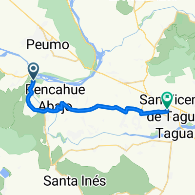
De Calle A. Gines Yáñez 104, San Vicente de Taguatagua a Aguas Claras 318, Peumo
Trasa rowerowa w San Vicente, O’Higgins, Chile
- 13,6 km
- Dystans
- 109 m
- Przewyższenia
- 141 m
- Spadek


De H-574 760, Quinta de Tilcoco a H-574 760, Quinta de Tilcoco
Trasa rowerowa w San Vicente, O’Higgins, Chile
- 22,9 km
- Dystans
- 265 m
- Przewyższenia
- 277 m
- Spadek


De H-50 035, Quinta de Tilcoco a H-50, Quinta de Tilcoco
Trasa rowerowa w San Vicente, O’Higgins, Chile
- 23,1 km
- Dystans
- 213 m
- Przewyższenia
- 222 m
- Spadek


De H-50, Quinta de Tilcoco a H-574, Quinta de Tilcoco
Trasa rowerowa w San Vicente, O’Higgins, Chile
- 106,8 km
- Dystans
- 449 m
- Przewyższenia
- 454 m
- Spadek
Odkryj więcej tras
 De H-588, San Vicente a H-588, San Vicente
- Dystans
- 25,7 km
- Przewyższenia
- 346 m
- Spadek
- 383 m
- Lokalizacja
- San Vicente, O’Higgins, Chile
 Ruta H-774, Peumo a Walker Martínez, Peumo
- Dystans
- 6,4 km
- Przewyższenia
- 23 m
- Spadek
- 6 m
- Lokalizacja
- San Vicente, O’Higgins, Chile
 De Camino Alto del Huesillo, San Vicente de Tagua Tagua a Camino Alto del Huesillo, San Vicente de Tagua Tagua
- Dystans
- 11,7 km
- Przewyższenia
- 373 m
- Spadek
- 375 m
- Lokalizacja
- San Vicente, O’Higgins, Chile
 parquímetros
- Dystans
- 14,1 km
- Przewyższenia
- 20 m
- Spadek
- 22 m
- Lokalizacja
- San Vicente, O’Higgins, Chile
 De Peumo a Avenida España 1536, San Vicente de Taguatagua
- Dystans
- 13,7 km
- Przewyższenia
- 117 m
- Spadek
- 87 m
- Lokalizacja
- San Vicente, O’Higgins, Chile
 sn vicente hasta laguna sn vicente..
- Dystans
- 24 km
- Przewyższenia
- 92 m
- Spadek
- 92 m
- Lokalizacja
- San Vicente, O’Higgins, Chile
 San Vicente - San José de Marchihue - Los Maitenes - Cruce Ruta 90 (Marchihue), San Vicente to Michimalongo 195–315, San Vicente
- Dystans
- 12,9 km
- Przewyższenia
- 40 m
- Spadek
- 12 m
- Lokalizacja
- San Vicente, O’Higgins, Chile
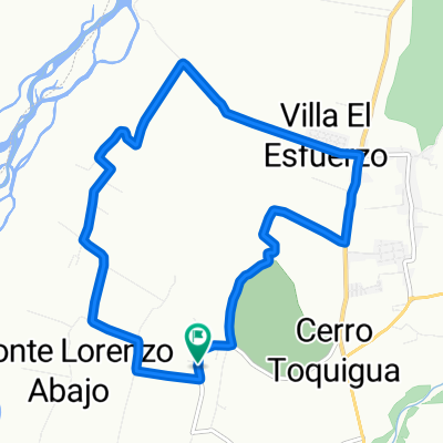 Cerro Toquihua Monte Lorenzo
- Dystans
- 11,7 km
- Przewyższenia
- 154 m
- Spadek
- 152 m
- Lokalizacja
- San Vicente, O’Higgins, Chile