
Kenner na rowerze
Odkrywaj mapę z 107 trasami rowerowymi i szlakami w pobliżu Kenner, stworzonymi przez naszą społeczność.
Portret regionu
Poznaj Kenner
Znajdź odpowiednią trasę rowerową dla siebie w Kenner – mamy tam 107 tras do odkrycia. Większość osób wybiera się tutaj na rower w miesiącach Kwiecień i Maj.
4912 km
Zarejestrowany dystans
107
Trasy rowerowe
66 702
Populacja
Wspólnota
Najaktywniejsi użytkownicy w Kenner
Od naszej społeczności
Najlepsze trasy rowerowe w Kenner i okolicach
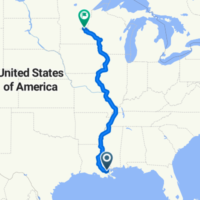
GREAT MISSISSIPPI RIVER RIDE
Trasa rowerowa w Kenner, Luizjana, USA
- 2605,5 km
- Dystans
- 865 m
- Przewyższenia
- 600 m
- Spadek
1501 Disney to Audubon Zoo via Mississippi River Levee Trail
Trasa rowerowa w Kenner, Luizjana, USA
This route is pancake flat. The only thing you need to worry about is the heat and shifting headwinds coming off the Mississippi River. it's about 30m RT and takes about 90-100 minutes.
- 23,4 km
- Dystans
- 52 m
- Przewyższenia
- 49 m
- Spadek
Morning Route to Work
Trasa rowerowa w Kenner, Luizjana, USA
Transcontinental Route is okay in the morning, Wabash is pretty sleepy in the morning. L&A Road has been a revelation! Smooth sailing into the city unless there's a train passing. The only hill that you'll have to be concerned about is the Palmetto Street overpass, be careful with a slight crack in the pavement when you make your decline. There's a rarely used on-ramp to the overpass, but do a quick look behind to the right before you ascend. Thalia Street is AWFUL! Slow down for lake-sized potholes. Felicity is under heavy construction as well, so you might want to consider taking Jackson Ave.
- 17,5 km
- Dystans
- 16 m
- Przewyższenia
- 14 m
- Spadek
Odkryj więcej tras
- New Orleans
- Dystans
- 79,7 km
- Przewyższenia
- 25 m
- Spadek
- 24 m
- Lokalizacja
- Kenner, Luizjana, USA
- River Levee To Spillway
- Dystans
- 22,9 km
- Przewyższenia
- 53 m
- Spadek
- 52 m
- Lokalizacja
- Kenner, Luizjana, USA
- Metairie Levee - Bucktown
- Dystans
- 20,9 km
- Przewyższenia
- 49 m
- Spadek
- 53 m
- Lokalizacja
- Kenner, Luizjana, USA
- first route. kenner to lake
- Dystans
- 13,7 km
- Przewyższenia
- 191 m
- Spadek
- 196 m
- Lokalizacja
- Kenner, Luizjana, USA
- 6604 Wilty St, Metairie to 6604 Wilty St, Metairie
- Dystans
- 7,3 km
- Przewyższenia
- 33 m
- Spadek
- 29 m
- Lokalizacja
- Kenner, Luizjana, USA
- 4300–4318 Elmwood Pkwy, Metairie to 6600 Wilty St, Metairie
- Dystans
- 8,4 km
- Przewyższenia
- 24 m
- Spadek
- 26 m
- Lokalizacja
- Kenner, Luizjana, USA
- 6600 Wilty St, Metairie to 6604 Wilty St, Metairie
- Dystans
- 7,5 km
- Przewyższenia
- 17 m
- Spadek
- 17 m
- Lokalizacja
- Kenner, Luizjana, USA
- Kenner to West End or So
- Dystans
- 13,5 km
- Przewyższenia
- 0 m
- Spadek
- 0 m
- Lokalizacja
- Kenner, Luizjana, USA