
Crockett na rowerze
Odkrywaj mapę rowerową Crockett, z wyróżnionymi ścieżkami, szlakami i punktami zainteresowania.
Bądź pionierem
Zainspiruj innych rowerzystów swoją trasą w Crockett
Bikemap to globalna społeczność rowerowa z milionami tras tworzonych przez rowerzystów takich jak Ty. W Crockett jest na razie tylko kilka tras, więc narysuj swoje ulubione przejazdy na mapie, by pomóc innym odkryć najlepsze trasy.
Od naszej społeczności
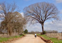
Najlepsze trasy rowerowe w Crockett i okolicach
Crockett to Palestine
Trasa rowerowa w Crockett, Texas, United States of America
After passing the northern part of the highway ring around Crockett, we were soon on a local road that had a temporary sign saying “Rough Road”. They weren’t kidding since after a short time we lost the pavement and had an unpaved road for a while. Getting into Latexo, we crossed over U.S. 287/Texas 19 onto a local road…that really turned out to be local. It was unpaved often with a sandy base that we had to push the bikes through. This went on for a number of miles until we got close to Grapeland when paving reappeared. Being gun-shy, we decided against the originally planned local roads which would have taken us to Elkhart and Palestine and took U.S. 287/Texas 19 instead. Noisy, but mostly good road shoulder to ride on.
Because of the sandy road conditions, this route was not good for a road bike. You should use US 287/Texas 19 instead of the small local roads.
- 63,1 km
- Dystans
- 512 m
- Przewyższenia
- 456 m
- Spadek
Crockett, TX - Buffalo, TX
Trasa rowerowa w Crockett, Texas, United States of America
Route for tour IcelandAcrossAmerica 2011
- 80,3 km
- Dystans
- 293 m
- Przewyższenia
- 281 m
- Spadek