
Smokey Point na rowerze
Odkrywaj mapę z 19 trasami rowerowymi i szlakami w pobliżu Smokey Point, stworzonymi przez naszą społeczność.
Portret regionu
Poznaj Smokey Point
Znajdź odpowiednią trasę rowerową dla siebie w Smokey Point – mamy tam 19 tras do odkrycia. Większość osób wybiera się tutaj na rower w miesiącu Maj.
569 km
Zarejestrowany dystans
19
Trasy rowerowe
1572
Populacja
Wspólnota
Najaktywniejsi użytkownicy w Smokey Point


Od naszej społeczności
Najlepsze trasy rowerowe w Smokey Point i okolicach


Arlington to Seattle
Trasa rowerowa w Smokey Point, Waszyngton, USA
- 97,6 km
- Dystans
- 1514 m
- Przewyższenia
- 1459 m
- Spadek

Easy ride in Arlington
Trasa rowerowa w Smokey Point, Waszyngton, USA
- 40,9 km
- Dystans
- 196 m
- Przewyższenia
- 195 m
- Spadek
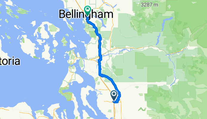
172nd St NE, Arlington to Lakeway Dr, Bellingham
Trasa rowerowa w Smokey Point, Waszyngton, USA
- 93,7 km
- Dystans
- 604 m
- Przewyższenia
- 593 m
- Spadek
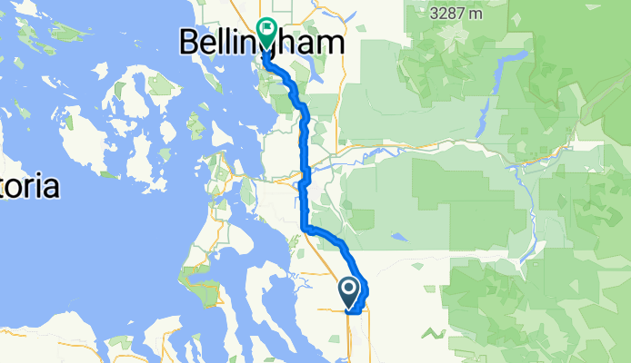
Smokey Point Dr, Arlington to Lakeway Dr, Bellingham
Trasa rowerowa w Smokey Point, Waszyngton, USA
- 92,3 km
- Dystans
- 964 m
- Przewyższenia
- 952 m
- Spadek
Odkryj więcej tras
 15405 67th Ave NE, Arlington to 15405 67th Ave NE, Arlington
- Dystans
- 10,9 km
- Przewyższenia
- 69 m
- Spadek
- 70 m
- Lokalizacja
- Smokey Point, Waszyngton, USA
 15405 67th Ave NE, Arlington to 15405 67th Ave NE, Arlington
- Dystans
- 11,1 km
- Przewyższenia
- 74 m
- Spadek
- 72 m
- Lokalizacja
- Smokey Point, Waszyngton, USA
 18828 Smokey Point Blvd, Arlington to 14714–14798 Summers Dr, Mount Vernon
- Dystans
- 42,1 km
- Przewyższenia
- 330 m
- Spadek
- 348 m
- Lokalizacja
- Smokey Point, Waszyngton, USA
 15291–15359 67th Ave NE, Arlington to 15405 67th Ave NE, Arlington
- Dystans
- 5,2 km
- Przewyższenia
- 23 m
- Spadek
- 23 m
- Lokalizacja
- Smokey Point, Waszyngton, USA
 15405 67th Ave NE, Arlington to 15405 67th Ave NE, Arlington
- Dystans
- 11,1 km
- Przewyższenia
- 65 m
- Spadek
- 66 m
- Lokalizacja
- Smokey Point, Waszyngton, USA
 15405 67th Ave NE, Arlington to 15405 67th Ave NE, Arlington
- Dystans
- 13 km
- Przewyższenia
- 118 m
- Spadek
- 116 m
- Lokalizacja
- Smokey Point, Waszyngton, USA
 15405 67th Ave NE, Arlington to 15405 67th Ave NE, Arlington
- Dystans
- 11,1 km
- Przewyższenia
- 86 m
- Spadek
- 87 m
- Lokalizacja
- Smokey Point, Waszyngton, USA
 hdjdj
hdjdj- Dystans
- 29,1 km
- Przewyższenia
- 653 m
- Spadek
- 634 m
- Lokalizacja
- Smokey Point, Waszyngton, USA