
Szablon trasy
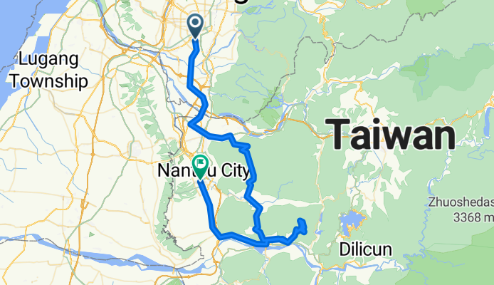
Z Taizhong do Nantou

- 2 h 28 min
- Czas
- 36,5 km
- Dystans
- 320 m
- Przewyższenia
- 210 m
- Spadek
- 14,8 km/h
- Śr. Prędkość
- 202 m
- Maks. wysokość
Ready for a scenic ride through central Taiwan? This route starts in the lively city of Taichung, famous for its vibrant night markets and laid-back vibes. From there, you’ll roll south toward Nantou City—known as a gateway to Taiwan’s picturesque hill country and tea plantations.
The ~36.5 km journey mostly follows quiet roads (so expect a chill ride), with only a short stretch on busier sections. You'll gain about 320 meters in elevation, so expect a few gentle climbs, but nothing too wild. With just under 40 km ahead, it's a satisfying ride for a morning or afternoon jaunt.
You’ll pedal past a mix of urban outskirts and open countryside, with glimpses of Taiwan’s central mountains on the horizon. Surfaces are mostly paved or asphalt, but some paths are a bit less refined—perfect for mixing up the scenery. Finish up in Nantou City, where you can explore local markets, grab a tea, or plan your next adventure further up into the mountains!
Wspólnota
Najlepsi użytkownicy w tym regionie


Od naszej społeczności
Najlepsze trasy rowerowe z Taizhong do Nantou

4月 約騎 - 鳳山寺
Trasa rowerowa w Taizhong, Taiwan, Tajwan
- 40,2 km
- Dystans
- 624 m
- Przewyższenia
- 274 m
- Spadek

12/8明天約騎鳳山寺
Trasa rowerowa w Taizhong, Taiwan, Tajwan
- 34,2 km
- Dystans
- 476 m
- Przewyższenia
- 124 m
- Spadek


微熱山丘爆肺行
Trasa rowerowa w Taizhong, Taiwan, Tajwan
- 36,1 km
- Dystans
- 444 m
- Przewyższenia
- 146 m
- Spadek


台中火車站--->136縣道
Trasa rowerowa w Taizhong, Taiwan, Tajwan
- 65,4 km
- Dystans
- 890 m
- Przewyższenia
- 933 m
- Spadek

139 Route 明道中學> 禾家牧場>鳳山寺
Trasa rowerowa w Taizhong, Taiwan, Tajwan
- 25,1 km
- Dystans
- 438 m
- Przewyższenia
- 102 m
- Spadek

文心星巴克 - 鳳山寺
Trasa rowerowa w Taizhong, Taiwan, Tajwan
- 42,5 km
- Dystans
- 607 m
- Przewyższenia
- 281 m
- Spadek


中興大學 --- 鳳山寺.微熱山丘
Trasa rowerowa w Taizhong, Taiwan, Tajwan
- 31,5 km
- Dystans
- 469 m
- Przewyższenia
- 120 m
- Spadek

柳川東路一段10號, 南區 to 八卦路1310號, 南投市
Trasa rowerowa w Taizhong, Taiwan, Tajwan
- 29 km
- Dystans
- 436 m
- Przewyższenia
- 94 m
- Spadek
Odkryj więcej tras
 西屯-鳳山寺-西屯
- Dystans
- 32,2 km
- Przewyższenia
- 585 m
- Spadek
- 268 m
- Lokalizacja
- Taizhong, Taiwan, Tajwan
 台中火車站--->136縣道
- Dystans
- 65,4 km
- Przewyższenia
- 890 m
- Spadek
- 933 m
- Lokalizacja
- Taizhong, Taiwan, Tajwan
 139 Route 明道中學> 禾家牧場>鳳山寺
- Dystans
- 25,1 km
- Przewyższenia
- 438 m
- Spadek
- 102 m
- Lokalizacja
- Taizhong, Taiwan, Tajwan
 文心星巴克 - 鳳山寺
- Dystans
- 42,5 km
- Przewyższenia
- 607 m
- Spadek
- 281 m
- Lokalizacja
- Taizhong, Taiwan, Tajwan
 台中-中投-南投
- Dystans
- 29,1 km
- Przewyższenia
- 1142 m
- Spadek
- 1100 m
- Lokalizacja
- Taizhong, Taiwan, Tajwan
 集集大山
集集大山- Dystans
- 107,6 km
- Przewyższenia
- 1713 m
- Spadek
- 1665 m
- Lokalizacja
- Taizhong, Taiwan, Tajwan
 中興大學 --- 鳳山寺.微熱山丘
- Dystans
- 31,5 km
- Przewyższenia
- 469 m
- Spadek
- 120 m
- Lokalizacja
- Taizhong, Taiwan, Tajwan
 柳川東路一段10號, 南區 to 八卦路1310號, 南投市
- Dystans
- 29 km
- Przewyższenia
- 436 m
- Spadek
- 94 m
- Lokalizacja
- Taizhong, Taiwan, Tajwan
Trasy z Taizhong
Bikepacking od
Z Taizhong do Tainan
Jednodniowa wycieczka rowerowa od
Z Taizhong do Chiayi City
Jednodniowa wycieczka rowerowa od
Z Taizhong do Lugu
Rowerowa od
Z Taizhong do Fengyuan
Trasy do Nantou
Jednodniowa wycieczka rowerowa od
Z Chang-hua do Nantou
Rowerowa od
Z Zhongxing New Village do Nantou