
Szablon trasy
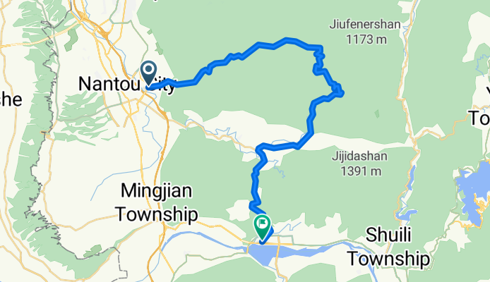
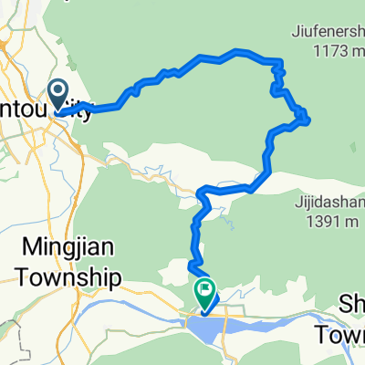
Z Nantou do Lugu

- 4 h 25 min
- Czas
- 42,6 km
- Dystans
- 1235 m
- Przewyższenia
- 932 m
- Spadek
- 9,6 km/h
- Śr. Prędkość
- 568 m
- Maks. wysokość
Get ready for a ride that showcases the heart of central Taiwan! Starting in Nantou City, you’ll set off from the lively county seat, famous for its night markets and city parks, and start pedaling southward into lush, rolling hills. The route to Lugu covers about 43 km with a good bit of climbing—over 1,200 meters of ascent—so pace yourself and enjoy the journey!
Most of the ride rolls along quiet access roads and scenic, peaceful stretches, with a touch of dedicated cycleway here and there. Expect to wind past farmland and forested hills, especially as you enter the tea country around Lugu, renowned for its award-winning Dong Ding Oolong. With a max elevation at almost 570 meters, you’ll definitely earn your downhill finish, which drops you right into the heart of Lugu township.
Pack some snacks and a camera—the views are great, especially as you get closer to the tea plantations. Once in Lugu, treat yourself to a tea tasting or a stroll through the bamboo forests. This ride offers a real taste of rural Taiwan and ends in one of its coziest towns!
Wspólnota
Najlepsi użytkownicy w tym regionie


Od naszej społeczności
Najlepsze trasy rowerowe z Nantou do Lugu


松柏嶺七上八下
Trasa rowerowa w Nantou, Taiwan, Tajwan
- 112 km
- Dystans
- 1726 m
- Przewyższenia
- 1883 m
- Spadek

濁水車站~溪頭
Trasa rowerowa w Nantou, Taiwan, Tajwan
- 36,2 km
- Dystans
- 1779 m
- Przewyższenia
- 274 m
- Spadek

Golf course to Jiji train station
Trasa rowerowa w Nantou, Taiwan, Tajwan
- 27 km
- Dystans
- 301 m
- Przewyższenia
- 300 m
- Spadek


Tienzhong to Checheng
Trasa rowerowa w Nantou, Taiwan, Tajwan
- 37 km
- Dystans
- 753 m
- Przewyższenia
- 422 m
- Spadek


20090419_4+2輪溪頭杉林溪探路行
Trasa rowerowa w Nantou, Taiwan, Tajwan
- 98,2 km
- Dystans
- 1910 m
- Przewyższenia
- 1896 m
- Spadek

Long Feng waterfall
Trasa rowerowa w Nantou, Taiwan, Tajwan
- 38,1 km
- Dystans
- 787 m
- Przewyższenia
- 660 m
- Spadek
Odkryj więcej tras
 濁水車站~溪頭
- Dystans
- 36,2 km
- Przewyższenia
- 1779 m
- Spadek
- 274 m
- Lokalizacja
- Nantou, Taiwan, Tajwan
 Golf course to Jiji train station
- Dystans
- 27 km
- Przewyższenia
- 301 m
- Spadek
- 300 m
- Lokalizacja
- Nantou, Taiwan, Tajwan
 二水-車埕
二水-車埕- Dystans
- 35,3 km
- Przewyższenia
- 584 m
- Spadek
- 344 m
- Lokalizacja
- Nantou, Taiwan, Tajwan
 Tienzhong to Checheng
- Dystans
- 37 km
- Przewyższenia
- 753 m
- Spadek
- 422 m
- Lokalizacja
- Nantou, Taiwan, Tajwan
 二水-明新書院
- Dystans
- 24,5 km
- Przewyższenia
- 295 m
- Spadek
- 136 m
- Lokalizacja
- Nantou, Taiwan, Tajwan
 20090419_4+2輪溪頭杉林溪探路行
- Dystans
- 98,2 km
- Przewyższenia
- 1910 m
- Spadek
- 1896 m
- Lokalizacja
- Nantou, Taiwan, Tajwan
 田中-妖怪村
- Dystans
- 41,3 km
- Przewyższenia
- 1113 m
- Spadek
- 49 m
- Lokalizacja
- Nantou, Taiwan, Tajwan
 Long Feng waterfall
- Dystans
- 38,1 km
- Przewyższenia
- 787 m
- Spadek
- 660 m
- Lokalizacja
- Nantou, Taiwan, Tajwan
Trasy z Nantou
Jednodniowa wycieczka rowerowa od
Z Nantou do Puli
Trasy do Lugu
Jednodniowa wycieczka rowerowa od
Z Taizhong do Lugu
Jednodniowa wycieczka rowerowa od
Z Puli do Lugu