
Szybka przejażdżka rowerowa z Makati City do San Juan
Dostosuj własną trasę na podstawie naszego szablonu lub zobacz, jak nasza społeczność najchętniej jeździ z Makati City do San Juan.
Szablon trasy
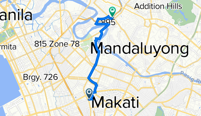
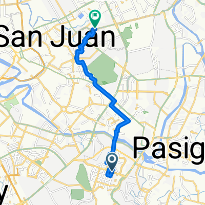
Z Makati City do San Juan

- 31 min
- Czas
- 9,1 km
- Dystans
- 75 m
- Przewyższenia
- 86 m
- Spadek
- 17,7 km/h
- Śr. Prędkość
- 40 m
- Maks. wysokość
This ride takes you from the bustling heart of Makati City up to the vibrant streets of San Juan City. It’s about 9 kilometers, so not too long—a nice way to stretch your legs without going epic mode! You’ll start surrounded by Makati’s skyscrapers and business centers, then head north through quieter neighborhoods, mixing things up between smooth asphalt and concrete. Most of the way is actually on peaceful streets, so you’ll get a break from the busier avenues.
Expect some gentle ups and downs, but nothing too tough—the highest point is only around 40 meters elevation. The route is just urban enough to remind you you’re in Metro Manila, passing through a few lively districts before reaching San Juan. San Juan’s famous for its heritage sites like the Pinaglabanan Shrine and a busy food scene.
All in all, this is a city ride with a relaxed vibe and a chance to see two distinct parts of the metro. Perfect for a weekday escape or a breezy weekend spin!
Wspólnota
Najlepsi użytkownicy w tym regionie


Od naszej społeczności
Najlepsze trasy rowerowe z Makati City do San Juan

Madrid, Parañaque to 2–216 N. Domingo Street, Quezon City
Trasa rowerowa w Makati City, National Capital Region, Filipiny
- 21,4 km
- Dystans
- 73 m
- Przewyższenia
- 51 m
- Spadek

Route from Sta Ana Drive, Parañaque
Trasa rowerowa w Makati City, National Capital Region, Filipiny
- 19,8 km
- Dystans
- 150 m
- Przewyższenia
- 134 m
- Spadek

Taguig to Xavier 71b, Manila
Trasa rowerowa w Makati City, National Capital Region, Filipiny
- 8,3 km
- Dystans
- 95 m
- Przewyższenia
- 98 m
- Spadek

General Antonio Luna Street, Makati to 22 Victorino Mapa Street, Manila
Trasa rowerowa w Makati City, National Capital Region, Filipiny
- 9,1 km
- Dystans
- 12 m
- Przewyższenia
- 9 m
- Spadek

C. Palanca 106, Makati to Jesus Extension 2723, Manila
Trasa rowerowa w Makati City, National Capital Region, Filipiny
- 8,2 km
- Dystans
- 63 m
- Przewyższenia
- 96 m
- Spadek

Kakarong 2945, Maynila to Ret Rev Aglipay 216, Mandaluyong
Trasa rowerowa w Makati City, National Capital Region, Filipiny
- 3,4 km
- Dystans
- 12 m
- Przewyższenia
- 11 m
- Spadek
Dela Rosa Street, Makati City to Bacood-Mandaluyong Bridge, Manila
Trasa rowerowa w Makati City, National Capital Region, Filipiny
- 5,6 km
- Dystans
- 44 m
- Przewyższenia
- 45 m
- Spadek


Rizal Drive 26, Taguig to Suter 2361, Manila
Trasa rowerowa w Makati City, National Capital Region, Filipiny
- 24 km
- Dystans
- 87 m
- Przewyższenia
- 67 m
- Spadek

Route to Greenhills Garden Square
Trasa rowerowa w Makati City, National Capital Region, Filipiny
- 10,3 km
- Dystans
- 77 m
- Przewyższenia
- 68 m
- Spadek

To Work
Trasa rowerowa w Makati City, National Capital Region, Filipiny
- 12,4 km
- Dystans
- 45 m
- Przewyższenia
- 28 m
- Spadek

Pablo Ocampo Sr. Extension 273, Makati to Guadalcanal Street 4630a, Manila
Trasa rowerowa w Makati City, National Capital Region, Filipiny
- 5,6 km
- Dystans
- 27 m
- Przewyższenia
- 21 m
- Spadek

Amorsolo Street, Makati to 213 Wilson Street, San Juan City
Trasa rowerowa w Makati City, National Capital Region, Filipiny
- 7,7 km
- Dystans
- 131 m
- Przewyższenia
- 120 m
- Spadek
Odkryj więcej tras
 C. Palanca 106, Makati to Jesus Extension 2723, Manila
- Dystans
- 8,2 km
- Przewyższenia
- 63 m
- Spadek
- 96 m
- Lokalizacja
- Makati City, National Capital Region, Filipiny
 Kakarong 2945, Maynila to Ret Rev Aglipay 216, Mandaluyong
- Dystans
- 3,4 km
- Przewyższenia
- 12 m
- Spadek
- 11 m
- Lokalizacja
- Makati City, National Capital Region, Filipiny
 Dela Rosa Street, Makati City to Bacood-Mandaluyong Bridge, Manila
- Dystans
- 5,6 km
- Przewyższenia
- 44 m
- Spadek
- 45 m
- Lokalizacja
- Makati City, National Capital Region, Filipiny
 Rizal Drive 26, Taguig to Suter 2361, Manila
- Dystans
- 24 km
- Przewyższenia
- 87 m
- Spadek
- 67 m
- Lokalizacja
- Makati City, National Capital Region, Filipiny
 Route to Greenhills Garden Square
- Dystans
- 10,3 km
- Przewyższenia
- 77 m
- Spadek
- 68 m
- Lokalizacja
- Makati City, National Capital Region, Filipiny
 To Work
- Dystans
- 12,4 km
- Przewyższenia
- 45 m
- Spadek
- 28 m
- Lokalizacja
- Makati City, National Capital Region, Filipiny
 Pablo Ocampo Sr. Extension 273, Makati to Guadalcanal Street 4630a, Manila
- Dystans
- 5,6 km
- Przewyższenia
- 27 m
- Spadek
- 21 m
- Lokalizacja
- Makati City, National Capital Region, Filipiny
 Amorsolo Street, Makati to 213 Wilson Street, San Juan City
- Dystans
- 7,7 km
- Przewyższenia
- 131 m
- Spadek
- 120 m
- Lokalizacja
- Makati City, National Capital Region, Filipiny
Trasy z Makati City
Jednodniowa wycieczka rowerowa od
Z Makati City do Niugan
Jednodniowa wycieczka rowerowa od
Z Makati City do Las Piñas
Szybka przejażdżka rowerowa od
Z Makati City do Port Area
Szybka przejażdżka rowerowa od
Z Makati City do Mandaluyong
Trasy do San Juan
Szybka przejażdżka rowerowa od
Z Mandaluyong do San Juan