

Jednodniowa wycieczka rowerowa z Seul do Gwangmyeong
Dostosuj własną trasę na podstawie naszego szablonu lub zobacz, jak nasza społeczność najchętniej jeździ z Seul do Gwangmyeong.
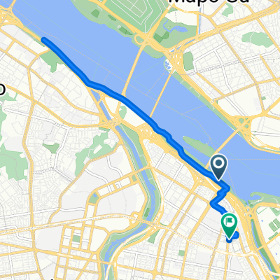
Szablon trasy
Z Seul do Gwangmyeong
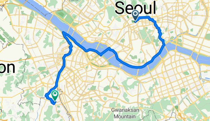
- 2 h 9 min
- Czas
- 36,2 km
- Dystans
- 391 m
- Przewyższenia
- 403 m
- Spadek
- 16,8 km/h
- Śr. Prędkość
- 100 m
- Maks. wysokość
Ready for a ride from the heart of Seoul to Gwangmyeong? This 36 km journey is mostly along smooth asphalt and paved cycleways, taking about 10 hours at a relaxed sightseeing pace (or much less if you’re in it for speed and coffee stops!). You'll leave behind Seoul’s iconic skyline, pedaling through city vibrance and then weaving out toward quieter neighborhoods.
The route climbs around 390 meters, so get ready for a few rolling hills, but nothing too intimidating. Most of the journey rides on well-kept bike paths, perfect for soaking in the Han River views while avoiding the traffic hustle.
Gwangmyeong is famous for its sparkling cave—a former mine turned into a surprising underground theme park—and a local vibe that’s a bit more laid-back compared to Seoul. Whether you’re out to explore or simply enjoy the Korean cycling culture, this trip packs both city excitement and suburban chill. Don’t forget your camera—you’ll want to capture those distinct changes in scenery!
Wspólnota
Najlepsi użytkownicy w tym regionie


Od naszej społeczności
Najlepsze trasy rowerowe z Seul do Gwangmyeong

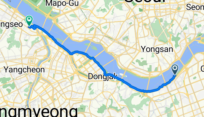
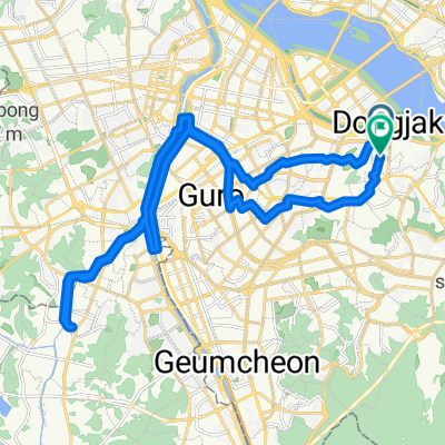
Han River /Banbpo Bridge Loop
Trasa rowerowa w Seul, Seoul, Korea Południowa
- 34,1 km
- Dystans
- 123 m
- Przewyższenia
- 128 m
- Spadek
![신대방동 395Ph0]으로 라우팅](https://media.bikemap.net/routes/13261797/staticmaps/in_414bb439-5dc2-4f05-8ab2-5254e07d0a32_694x400_bikemap-2021-3D-static.png)
신대방동 395Ph0]으로 라우팅
Trasa rowerowa w Seul, Seoul, Korea Południowa
- 21,9 km
- Dystans
- 190 m
- Przewyższenia
- 202 m
- Spadek
잠원로, 서울특별시에서 염창동, 서울특별시까지
Trasa rowerowa w Seul, Seoul, Korea Południowa
- 15,9 km
- Dystans
- 243 m
- Przewyższenia
- 224 m
- Spadek
![독산동 1000-5Ph0]으로 라우팅](https://media.bikemap.net/routes/17585784/staticmaps/in_7e0381b3-ad2b-4647-8b03-d07a57bcd2e8_694x400_bikemap-2021-3D-static.png)
독산동 1000-5Ph0]으로 라우팅
Trasa rowerowa w Seul, Seoul, Korea Południowa
- 16,6 km
- Dystans
- 32 m
- Przewyższenia
- 57 m
- Spadek
![독산동 706-4Ph0]으로 라우팅](https://media.bikemap.net/routes/17532887/staticmaps/in_ceb9c4e9-1d55-4c44-93cd-e118e6180db6_694x400_bikemap-2021-3D-static.png)
독산동 706-4Ph0]으로 라우팅
Trasa rowerowa w Seul, Seoul, Korea Południowa
- 15,1 km
- Dystans
- 10 m
- Przewyższenia
- 33 m
- Spadek
![Ph0]에서 경로대한민국](https://media.bikemap.net/routes/17474035/staticmaps/in_bd7d1e1c-dc61-48cb-b9b6-198b6badc619_694x400_bikemap-2021-3D-static.png)
Ph0]에서 경로대한민국
Trasa rowerowa w Seul, Seoul, Korea Południowa
- 10,7 km
- Dystans
- 52 m
- Przewyższenia
- 68 m
- Spadek
![신길동 45-1Ph0]으로 라우팅](https://media.bikemap.net/routes/17460968/staticmaps/in_90b8e661-a7f8-4868-aab6-9456a95122df_694x400_bikemap-2021-3D-static.png)
신길동 45-1Ph0]으로 라우팅
Trasa rowerowa w Seul, Seoul, Korea Południowa
- 6,5 km
- Dystans
- 60 m
- Przewyższenia
- 61 m
- Spadek
당산동, 서울특별시에서 영중로, 서울특별시까지
Trasa rowerowa w Seul, Seoul, Korea Południowa
- 10,9 km
- Dystans
- 68 m
- Przewyższenia
- 64 m
- Spadek
![신길동 31-18Ph0]으로 라우팅](https://media.bikemap.net/routes/17454199/staticmaps/in_3c9423f1-0fbe-4792-8e51-1eec20805a56_694x400_bikemap-2021-3D-static.png)
신길동 31-18Ph0]으로 라우팅
Trasa rowerowa w Seul, Seoul, Korea Południowa
- 4,5 km
- Dystans
- 47 m
- Przewyższenia
- 37 m
- Spadek
![문래동4가Ph0]으로 라우팅](https://media.bikemap.net/routes/17363652/staticmaps/in_c2ba3d1f-01c7-4569-ab3b-397909b85f87_694x400_bikemap-2021-3D-static.png)
문래동4가Ph0]으로 라우팅
Trasa rowerowa w Seul, Seoul, Korea Południowa
- 17,1 km
- Dystans
- 30 m
- Przewyższenia
- 56 m
- Spadek
노량진동, 서울특별시 to 노량진동, 서울특별시
Trasa rowerowa w Seul, Seoul, Korea Południowa
- 31,8 km
- Dystans
- 205 m
- Przewyższenia
- 206 m
- Spadek
![대한민국Ph0]으로 라우팅](https://media.bikemap.net/routes/17404706/staticmaps/in_95552c6c-38af-4d09-9af7-280e1bba3fee_694x400_bikemap-2021-3D-static.png)
대한민국Ph0]으로 라우팅
Trasa rowerowa w Seul, Seoul, Korea Południowa
- 4,8 km
- Dystans
- 19 m
- Przewyższenia
- 29 m
- Spadek
Odkryj więcej tras
![독산동 706-4Ph0]으로 라우팅](https://media.bikemap.net/routes/17532887/staticmaps/in_ceb9c4e9-1d55-4c44-93cd-e118e6180db6_400x400_bikemap-2021-3D-static.png) 독산동 706-4Ph0]으로 라우팅
독산동 706-4Ph0]으로 라우팅- Dystans
- 15,1 km
- Przewyższenia
- 10 m
- Spadek
- 33 m
- Lokalizacja
- Seul, Seoul, Korea Południowa
![Ph0]에서 경로대한민국](https://media.bikemap.net/routes/17474035/staticmaps/in_bd7d1e1c-dc61-48cb-b9b6-198b6badc619_400x400_bikemap-2021-3D-static.png) Ph0]에서 경로대한민국
Ph0]에서 경로대한민국- Dystans
- 10,7 km
- Przewyższenia
- 52 m
- Spadek
- 68 m
- Lokalizacja
- Seul, Seoul, Korea Południowa
![신길동 45-1Ph0]으로 라우팅](https://media.bikemap.net/routes/17460968/staticmaps/in_90b8e661-a7f8-4868-aab6-9456a95122df_400x400_bikemap-2021-3D-static.png) 신길동 45-1Ph0]으로 라우팅
신길동 45-1Ph0]으로 라우팅- Dystans
- 6,5 km
- Przewyższenia
- 60 m
- Spadek
- 61 m
- Lokalizacja
- Seul, Seoul, Korea Południowa
 당산동, 서울특별시에서 영중로, 서울특별시까지
- Dystans
- 10,9 km
- Przewyższenia
- 68 m
- Spadek
- 64 m
- Lokalizacja
- Seul, Seoul, Korea Południowa
![신길동 31-18Ph0]으로 라우팅](https://media.bikemap.net/routes/17454199/staticmaps/in_3c9423f1-0fbe-4792-8e51-1eec20805a56_400x400_bikemap-2021-3D-static.png) 신길동 31-18Ph0]으로 라우팅
신길동 31-18Ph0]으로 라우팅- Dystans
- 4,5 km
- Przewyższenia
- 47 m
- Spadek
- 37 m
- Lokalizacja
- Seul, Seoul, Korea Południowa
![문래동4가Ph0]으로 라우팅](https://media.bikemap.net/routes/17363652/staticmaps/in_c2ba3d1f-01c7-4569-ab3b-397909b85f87_400x400_bikemap-2021-3D-static.png) 문래동4가Ph0]으로 라우팅
문래동4가Ph0]으로 라우팅- Dystans
- 17,1 km
- Przewyższenia
- 30 m
- Spadek
- 56 m
- Lokalizacja
- Seul, Seoul, Korea Południowa
 노량진동, 서울특별시 to 노량진동, 서울특별시
- Dystans
- 31,8 km
- Przewyższenia
- 205 m
- Spadek
- 206 m
- Lokalizacja
- Seul, Seoul, Korea Południowa
![대한민국Ph0]으로 라우팅](https://media.bikemap.net/routes/17404706/staticmaps/in_95552c6c-38af-4d09-9af7-280e1bba3fee_400x400_bikemap-2021-3D-static.png) 대한민국Ph0]으로 라우팅
대한민국Ph0]으로 라우팅- Dystans
- 4,8 km
- Przewyższenia
- 19 m
- Spadek
- 29 m
- Lokalizacja
- Seul, Seoul, Korea Południowa
Trasy z Seul
Bikepacking od
Z Seul do Pusan
Jednodniowa wycieczka rowerowa od
Z Seul do Hanam
Jednodniowa wycieczka rowerowa od
Z Seul do Guri-si
Trasy do Gwangmyeong
Jednodniowa wycieczka rowerowa od
Z Anyang-si do Gwangmyeong
Szybka przejażdżka rowerowa od
Z Bucheon-si do Gwangmyeong