Jak może wyglądać jazda na rowerze w Maspalomas.
Jak może wyglądać jazda na rowerze w Playa del Ingles.

Szybka przejażdżka rowerowa z Maspalomas do Playa del Ingles

Dostosuj własną trasę na podstawie naszego szablonu lub zobacz, jak nasza społeczność najchętniej jeździ z Maspalomas do Playa del Ingles.

Szablon trasy

Z Maspalomas do Playa del Ingles

5 min
Czas
1,5 km
Dystans
25 m
Przewyższenia
7 m
Spadek
16,9 km/h
Śr. Prędkość
47 m
Maks. wysokość

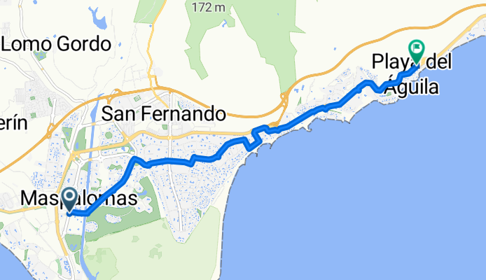
This is a super easy and scenic ride that links two of Gran Canaria’s most famous beach resorts: Maspalomas and Playa del Inglés. You'll be cycling just about 1.5 km, so it’s perfect for a relaxed spin—maybe even in flip-flops!

Starting in Maspalomas, known for its sweeping golden sand dunes and iconic lighthouse, you’ll cruise mostly on quiet roads, glancing over at lush gardens and palm trees. There’s a short, gentle climb (about 25 meters up—no sweat) before you roll down slightly toward Playa del Inglés.

Over 85% of the way is smooth asphalt or paving, so the ride is comfortable, though you’ll pass a tiny stretch less finished—just keep an eye out. Playa del Inglés is super lively, with endless restaurants, bars, and, of course, its beautiful, wide beach. If you fancy, stick around for a swim or an ice cream!

All told, it’s the perfect little coast-hugging hop between two Canary Island highlights.

Wycieczki bikepackingowe

Już podzielone na idealne etapy przez naszą społeczność

jamie g
Wycieczka

gran canaria

Wycieczka od jamie g

7 tras

Wycieczka

GC22

Wycieczka od paul Griffin

4 trasy

Wspólnota

Najlepsi użytkownicy w tym regionie

Od naszej społeczności

Najlepsze trasy rowerowe z Maspalomas do Playa del Ingles

EL TABLERO-JUAN GRANDE
Rower górski
Ignacio Cardenal Flores
4

EL TABLERO-JUAN GRANDE

Trasa rowerowa w Maspalomas, Wyspy Kanaryjskie, Hiszpania

Trasa wzdłuż wybrzeża z Playa del Inglés do Maspalomas.
18,4 km
Dystans
124 m
Przewyższenia
204 m
Spadek
Playa del ingles - Tal der Tränen
Rower miejski
Ralph Neuhaus
1

Playa del ingles - Tal der Tränen

Trasa rowerowa w Maspalomas, Wyspy Kanaryjskie, Hiszpania

121,9 km
Dystans
3008 m
Przewyższenia
3008 m
Spadek
South coast - Mogan - Anagua - San Bartolomé - Fatata - Maspalomas
Rower szosowy
Spies/Ving
21

South coast - Mogan - Anagua - San Bartolomé - Fatata - Maspalomas

Trasa rowerowa w Maspalomas, Wyspy Kanaryjskie, Hiszpania

Climbers delight with a guarantee of suffering. Use all day for this stage, and book a nice massage in your hotel upon return. Note: The road down to Soira is pretty bad. So take it easy and very slow. We changed the route due to closed sea side road near Puerto de Mogan
137 km
Dystans
2964 m
Przewyższenia
2963 m
Spadek
Grand Canyon XL
Rower górski
Stephan Uhlmann
5

Grand Canyon XL

Trasa rowerowa w Maspalomas, Wyspy Kanaryjskie, Hiszpania

Grand Canyon XL tour as guided by Free Motion. Starts/ends in Maspalomas. Beginning of track is missing. The XL extension is optional.
49,3 km
Dystans
917 m
Przewyższenia
974 m
Spadek
santa Lucia
Rower szosowy
georgebiker
0

santa Lucia

Trasa rowerowa w Maspalomas, Wyspy Kanaryjskie, Hiszpania

75 km
Dystans
1200 m
Przewyższenia
1180 m
Spadek
1

Paradise Canyon + citytour

Trasa rowerowa w Maspalomas, Wyspy Kanaryjskie, Hiszpania

28,6 km
Dystans
264 m
Przewyższenia
567 m
Spadek
29

Ho Ho Home in time for tea

Trasa rowerowa w Maspalomas, Wyspy Kanaryjskie, Hiszpania

My Christmas escape route. If you have a car I suggest starting and finishing this route in Aldea Blanca.  If you have a lift or don't mind using public transport, you could start at the bottom of the hill in San Fernando and end in Aldea Blanca. Either way, Fataga makes an excellent midwway …
48,4 km
Dystans
1084 m
Przewyższenia
1084 m
Spadek
0

Etape 4 Ayagaures - Montana La Data

Trasa rowerowa w Maspalomas, Wyspy Kanaryjskie, Hiszpania

36,3 km
Dystans
508 m
Przewyższenia
531 m
Spadek
GC Tour 8 Santa Lucia
Rower górski
1

GC Tour 8 Santa Lucia

Trasa rowerowa w Maspalomas, Wyspy Kanaryjskie, Hiszpania

71,9 km
Dystans
907 m
Przewyższenia
908 m
Spadek

Odkryj więcej tras