
Jednodniowa wycieczka rowerowa z Huétor Vega do Grenada
Dostosuj własną trasę na podstawie naszego szablonu lub zobacz, jak nasza społeczność najchętniej jeździ z Huétor Vega do Grenada.
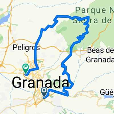
Szablon trasy
Z Huétor Vega do Grenada

- 1 h 29 min
- Czas
- 25,4 km
- Dystans
- 123 m
- Przewyższenia
- 178 m
- Spadek
- 17,2 km/h
- Śr. Prędkość
- 747 m
- Maks. wysokość
This ride takes you from the charming hillside town of Huétor Vega straight into the heart of Granada. Starting just south of the Sierra Nevada foothills, Huétor Vega is known for its tapas bars and scenic olive groves—you'll get some beautiful views as you roll out of town.
The route is roughly 25 km, mainly on quiet roads and cycleways, so it’s a relaxed cruise with only a bit of climbing at the start. Expect smooth tarmac for most of the ride, with just a dash of gravel to keep things interesting, but it's mostly easy-going even if you’re on a road bike.
As you approach Granada, you’ll notice the city’s blend of old and new. You’re arriving in one of Spain’s most beautiful cities, famous for the magnificent Alhambra and its vibrant streets. It’s a perfect ride if you want countryside vistas mixed with urban energy—plus, there are plenty of cafés in Granada to unwind when you finish!
Wspólnota
Najlepsi użytkownicy w tym regionie


Od naszej społeczności
Najlepsze trasy rowerowe z Huétor Vega do Grenada

GR243-Purche-Poyos-Cortijuela (15/11/09)
Trasa rowerowa w Huétor Vega, Andaluzja, Hiszpania
- 46,4 km
- Dystans
- 1693 m
- Przewyższenia
- 1571 m
- Spadek

GR-Alcudia de Guadix (panadería Sierra)
Trasa rowerowa w Huétor Vega, Andaluzja, Hiszpania
- 121,4 km
- Dystans
- 1885 m
- Przewyższenia
- 1846 m
- Spadek

Prueba BikeMap por la Vega
Trasa rowerowa w Huétor Vega, Andaluzja, Hiszpania
- 10,9 km
- Dystans
- 69 m
- Przewyższenia
- 172 m
- Spadek

GR-Lavaderos de la Reina-GR
Trasa rowerowa w Huétor Vega, Andaluzja, Hiszpania
- 82,6 km
- Dystans
- 1835 m
- Przewyższenia
- 1847 m
- Spadek

Granada-Sendero Yedra-Cañada del Sereno-Huetor Santillan-Granada GR155
Trasa rowerowa w Huétor Vega, Andaluzja, Hiszpania
- 52,1 km
- Dystans
- 1121 m
- Przewyższenia
- 1091 m
- Spadek

GR367 - Fte. de la Teja - Chorrillo - GR367
Trasa rowerowa w Huétor Vega, Andaluzja, Hiszpania
- 52,9 km
- Dystans
- 987 m
- Przewyższenia
- 964 m
- Spadek

GR199-Sierra de Huetor-Aguas Blanquillas 12-01-09
Trasa rowerowa w Huétor Vega, Andaluzja, Hiszpania
- 62,7 km
- Dystans
- 1025 m
- Przewyższenia
- 1036 m
- Spadek

Yedra-Cueva del Agua - GR195
Trasa rowerowa w Huétor Vega, Andaluzja, Hiszpania
- 44,8 km
- Dystans
- 1094 m
- Przewyższenia
- 1051 m
- Spadek

Sierra de Huétor - Cañada del Sereno - GR040 19/03/06
Trasa rowerowa w Huétor Vega, Andaluzja, Hiszpania
- 48,8 km
- Dystans
- 1380 m
- Przewyższenia
- 1207 m
- Spadek

Gr - Guejar - Alguacil - Tocón - Alhambra
Trasa rowerowa w Huétor Vega, Andaluzja, Hiszpania
- 75,3 km
- Dystans
- 1435 m
- Przewyższenia
- 1420 m
- Spadek

200305 - Cueva del Agua Sierra Huétor
Trasa rowerowa w Huétor Vega, Andaluzja, Hiszpania
- 39,6 km
- Dystans
- 946 m
- Przewyższenia
- 928 m
- Spadek

Fuente la Teja, Cortijo Carifaquín, Güevéjar - GR033
Trasa rowerowa w Huétor Vega, Andaluzja, Hiszpania
- 56 km
- Dystans
- 935 m
- Przewyższenia
- 972 m
- Spadek
Odkryj więcej tras
 Granada-Sendero Yedra-Cañada del Sereno-Huetor Santillan-Granada GR155
- Dystans
- 52,1 km
- Przewyższenia
- 1121 m
- Spadek
- 1091 m
- Lokalizacja
- Huétor Vega, Andaluzja, Hiszpania
 GR367 - Fte. de la Teja - Chorrillo - GR367
- Dystans
- 52,9 km
- Przewyższenia
- 987 m
- Spadek
- 964 m
- Lokalizacja
- Huétor Vega, Andaluzja, Hiszpania
 GR199-Sierra de Huetor-Aguas Blanquillas 12-01-09
- Dystans
- 62,7 km
- Przewyższenia
- 1025 m
- Spadek
- 1036 m
- Lokalizacja
- Huétor Vega, Andaluzja, Hiszpania
 Yedra-Cueva del Agua - GR195
- Dystans
- 44,8 km
- Przewyższenia
- 1094 m
- Spadek
- 1051 m
- Lokalizacja
- Huétor Vega, Andaluzja, Hiszpania
 Sierra de Huétor - Cañada del Sereno - GR040 19/03/06
- Dystans
- 48,8 km
- Przewyższenia
- 1380 m
- Spadek
- 1207 m
- Lokalizacja
- Huétor Vega, Andaluzja, Hiszpania
 Gr - Guejar - Alguacil - Tocón - Alhambra
- Dystans
- 75,3 km
- Przewyższenia
- 1435 m
- Spadek
- 1420 m
- Lokalizacja
- Huétor Vega, Andaluzja, Hiszpania
 200305 - Cueva del Agua Sierra Huétor
- Dystans
- 39,6 km
- Przewyższenia
- 946 m
- Spadek
- 928 m
- Lokalizacja
- Huétor Vega, Andaluzja, Hiszpania
 Fuente la Teja, Cortijo Carifaquín, Güevéjar - GR033
- Dystans
- 56 km
- Przewyższenia
- 935 m
- Spadek
- 972 m
- Lokalizacja
- Huétor Vega, Andaluzja, Hiszpania