
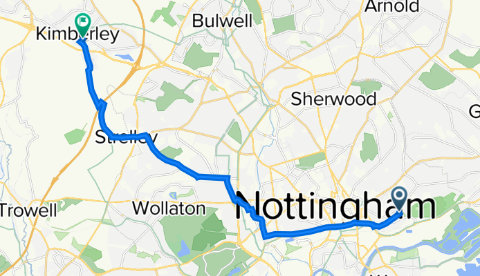
Szybka przejażdżka rowerowa z Nottingham do Kimberley
Dostosuj własną trasę na podstawie naszego szablonu lub zobacz, jak nasza społeczność najchętniej jeździ z Nottingham do Kimberley.
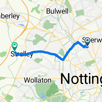
Szablon trasy
Z Nottingham do Kimberley

- 46 min
- Czas
- 13,1 km
- Dystans
- 132 m
- Przewyższenia
- 88 m
- Spadek
- 17 km/h
- Śr. Prędkość
- 116 m
- Maks. wysokość
This ride takes you from the lively city of Nottingham—home of Robin Hood legend, historic pubs, and a buzzing student scene—to the charming town of Kimberley on the edge of the Erewash Valley. The route covers just over 13 km with a mix of mostly paved and asphalt surfaces, weaving mostly along quiet roads and dedicated cycleways, so you can enjoy the ride without dodging much traffic.
You'll experience a gentle sweep of hills with about 130 meters of climbing—enough to get your legs working but nothing too brutal. The scenery transitions from urban Nottingham to more suburban and semi-rural stretches as you approach Kimberley, known for its old brewing heritage and the gateway to the Nottinghamshire countryside.
It's a relaxed ride for those looking to explore a bit beyond the city at a steady pace, with just a few stretches of gravel and unpaved path to keep things interesting. Pack a snack, bring a camera for a few leafy views, and enjoy a pleasant pedal between two classic East Midlands towns!
Wspólnota
Najlepsi użytkownicy w tym regionie


Od naszej społeczności
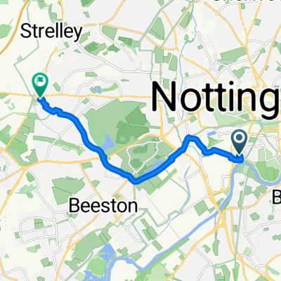
Najlepsze trasy rowerowe z Nottingham do Kimberley

Route in Nottingham
Trasa rowerowa w Nottingham, Anglia, Zjednoczone Królestwo Wielkiej Brytanii
- 27 km
- Dystans
- 193 m
- Przewyższenia
- 141 m
- Spadek
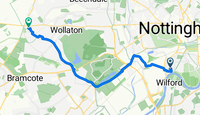
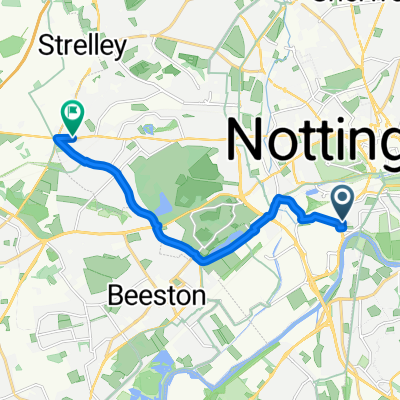
Wollaton Road, Nottingham to Denewood Crescent, Nottingham
Trasa rowerowa w Nottingham, Anglia, Zjednoczone Królestwo Wielkiej Brytanii
- 3,3 km
- Dystans
- 37 m
- Przewyższenia
- 12 m
- Spadek

Trowell Moor
Trasa rowerowa w Nottingham, Anglia, Zjednoczone Królestwo Wielkiej Brytanii
- 13,5 km
- Dystans
- 203 m
- Przewyższenia
- 99 m
- Spadek

25 Camelot Ave, Nottingham to The Stables, Strelley Hall, Main St, Nottingham
Trasa rowerowa w Nottingham, Anglia, Zjednoczone Królestwo Wielkiej Brytanii
- 7,2 km
- Dystans
- 84 m
- Przewyższenia
- 22 m
- Spadek

25 Camelot Ave, Nottingham to The Stables, Strelley Hall, Main St, Nottingham
Trasa rowerowa w Nottingham, Anglia, Zjednoczone Królestwo Wielkiej Brytanii
- 7 km
- Dystans
- 82 m
- Przewyższenia
- 19 m
- Spadek

42 Camelot Ave, Nottingham to The Stables, Strelley Hall, Main St, Nottingham
Trasa rowerowa w Nottingham, Anglia, Zjednoczone Królestwo Wielkiej Brytanii
- 7 km
- Dystans
- 91 m
- Przewyższenia
- 28 m
- Spadek
49 Port Arthur Road, Nottingham to 17 Regent St, Nottingham
Trasa rowerowa w Nottingham, Anglia, Zjednoczone Królestwo Wielkiej Brytanii
- 13,7 km
- Dystans
- 136 m
- Przewyższenia
- 67 m
- Spadek
Fossil Close, Nottingham to Firbeck Road, Nottingham
Trasa rowerowa w Nottingham, Anglia, Zjednoczone Królestwo Wielkiej Brytanii
- 8,4 km
- Dystans
- 56 m
- Przewyższenia
- 13 m
- Spadek
Sandstone Mews, Nottingham to Plantation Road, Nottingham
Trasa rowerowa w Nottingham, Anglia, Zjednoczone Królestwo Wielkiej Brytanii
- 8,9 km
- Dystans
- 57 m
- Przewyższenia
- 11 m
- Spadek

25 Camelot Ave, Nottingham to The Stables, Strelley Hall, Main St, Nottingham
Trasa rowerowa w Nottingham, Anglia, Zjednoczone Królestwo Wielkiej Brytanii
- 7,1 km
- Dystans
- 79 m
- Przewyższenia
- 20 m
- Spadek

23 Camelot Ave, Nottingham to The Stables, Strelley Hall, Main St, Nottingham
Trasa rowerowa w Nottingham, Anglia, Zjednoczone Królestwo Wielkiej Brytanii
- 7 km
- Dystans
- 161 m
- Przewyższenia
- 100 m
- Spadek

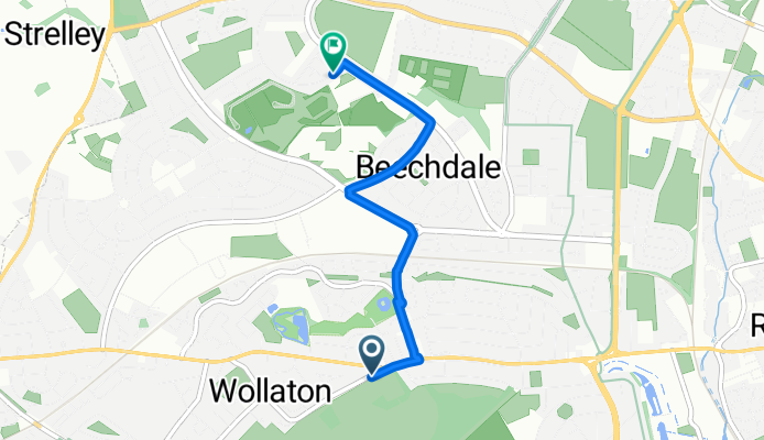
Hilcot Drive 51 to Wigman Road 105
Trasa rowerowa w Nottingham, Anglia, Zjednoczone Królestwo Wielkiej Brytanii
- 2,4 km
- Dystans
- 13 m
- Przewyższenia
- 8 m
- Spadek
Odkryj więcej tras
 25 Camelot Ave, Nottingham to The Stables, Strelley Hall, Main St, Nottingham
- Dystans
- 7 km
- Przewyższenia
- 82 m
- Spadek
- 19 m
- Lokalizacja
- Nottingham, Anglia, Zjednoczone Królestwo Wielkiej Brytanii
 42 Camelot Ave, Nottingham to The Stables, Strelley Hall, Main St, Nottingham
- Dystans
- 7 km
- Przewyższenia
- 91 m
- Spadek
- 28 m
- Lokalizacja
- Nottingham, Anglia, Zjednoczone Królestwo Wielkiej Brytanii
 49 Port Arthur Road, Nottingham to 17 Regent St, Nottingham
- Dystans
- 13,7 km
- Przewyższenia
- 136 m
- Spadek
- 67 m
- Lokalizacja
- Nottingham, Anglia, Zjednoczone Królestwo Wielkiej Brytanii
 Fossil Close, Nottingham to Firbeck Road, Nottingham
- Dystans
- 8,4 km
- Przewyższenia
- 56 m
- Spadek
- 13 m
- Lokalizacja
- Nottingham, Anglia, Zjednoczone Królestwo Wielkiej Brytanii
 Sandstone Mews, Nottingham to Plantation Road, Nottingham
- Dystans
- 8,9 km
- Przewyższenia
- 57 m
- Spadek
- 11 m
- Lokalizacja
- Nottingham, Anglia, Zjednoczone Królestwo Wielkiej Brytanii
 25 Camelot Ave, Nottingham to The Stables, Strelley Hall, Main St, Nottingham
- Dystans
- 7,1 km
- Przewyższenia
- 79 m
- Spadek
- 20 m
- Lokalizacja
- Nottingham, Anglia, Zjednoczone Królestwo Wielkiej Brytanii
 23 Camelot Ave, Nottingham to The Stables, Strelley Hall, Main St, Nottingham
- Dystans
- 7 km
- Przewyższenia
- 161 m
- Spadek
- 100 m
- Lokalizacja
- Nottingham, Anglia, Zjednoczone Królestwo Wielkiej Brytanii
 Hilcot Drive 51 to Wigman Road 105
- Dystans
- 2,4 km
- Przewyższenia
- 13 m
- Spadek
- 8 m
- Lokalizacja
- Nottingham, Anglia, Zjednoczone Królestwo Wielkiej Brytanii
Trasy z Nottingham
Szybka przejażdżka rowerowa od
Z Nottingham do Radcliffe on Trent