
Rowerowa z City of London do Camden Town
Dostosuj własną trasę na podstawie naszego szablonu lub zobacz, jak nasza społeczność najchętniej jeździ z City of London do Camden Town.
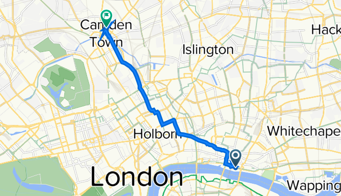
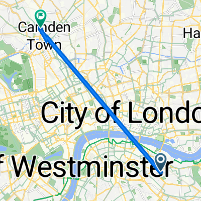
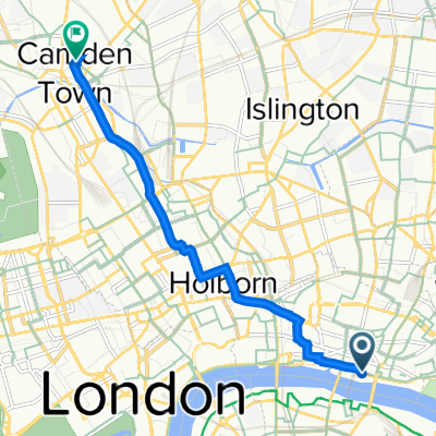
Szablon trasy
Z City of London do Camden Town

- 41 min
- Czas
- 11,8 km
- Dystans
- 64 m
- Przewyższenia
- 60 m
- Spadek
- 17,2 km/h
- Śr. Prędkość
- 50 m
- Maks. wysokość
Hop on your bike for a city adventure from the historic heart of the City of London to the vibrant neighborhood of Camden! This roughly 12 km ride weaves north through the bustling streets, transitioning smoothly from the high-rises and medieval lanes of the City to the creative energy of Camden’s markets and canals.
You’ll mainly stick to well-paved cycleways and quiet roads, making for an easygoing and safe ride, with just a couple of gentle climbs and descents to keep things interesting (total ascent and descent are both just over 60 meters). It’s a brilliant way to see London’s changing character—starting amidst iconic landmarks like St. Paul’s and The Gherkin, and ending up in Camden, famous for its street food, live music, and colorful market stalls. Keep an eye out for photo ops along Regent’s Canal near journey’s end!
Whether you’re commuting or just exploring, this route’s a great slice of London on two wheels.
Wspólnota
Najlepsi użytkownicy w tym regionie

Od naszej społeczności
Najlepsze trasy rowerowe z City of London do Camden Town

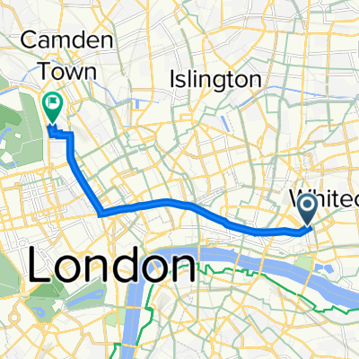
London - Tower of London to Camden.
Trasa rowerowa w City of London, Anglia, Zjednoczone Królestwo Wielkiej Brytanii
- 8,2 km
- Dystans
- 81 m
- Przewyższenia
- 66 m
- Spadek

Londen
Trasa rowerowa w City of London, Anglia, Zjednoczone Królestwo Wielkiej Brytanii
- 19,7 km
- Dystans
- 93 m
- Przewyższenia
- 80 m
- Spadek

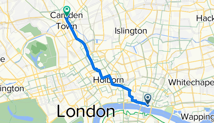
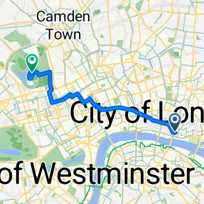
47-57 Gresham St, London to 137 Queen's Crescent, London
Trasa rowerowa w City of London, Anglia, Zjednoczone Królestwo Wielkiej Brytanii
- 6,7 km
- Dystans
- 58 m
- Przewyższenia
- 37 m
- Spadek
1 Angel Lane, London to 116 St Pancras Way, London
Trasa rowerowa w City of London, Anglia, Zjednoczone Królestwo Wielkiej Brytanii
- 7,2 km
- Dystans
- 106 m
- Przewyższenia
- 88 m
- Spadek

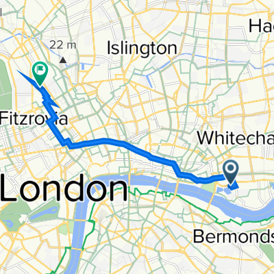
pottery
Trasa rowerowa w City of London, Anglia, Zjednoczone Królestwo Wielkiej Brytanii
- 7,2 km
- Dystans
- 95 m
- Przewyższenia
- 64 m
- Spadek

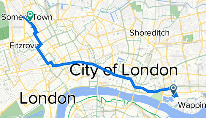
1 Aldgate, London to 1–7 Delancey St, London
Trasa rowerowa w City of London, Anglia, Zjednoczone Królestwo Wielkiej Brytanii
- 6,4 km
- Dystans
- 166 m
- Przewyższenia
- 137 m
- Spadek

Aldgate Station, Aldgate High St, London to Bagshot House, Redhill St, London
Trasa rowerowa w City of London, Anglia, Zjednoczone Królestwo Wielkiej Brytanii
- 6,1 km
- Dystans
- 57 m
- Przewyższenia
- 57 m
- Spadek
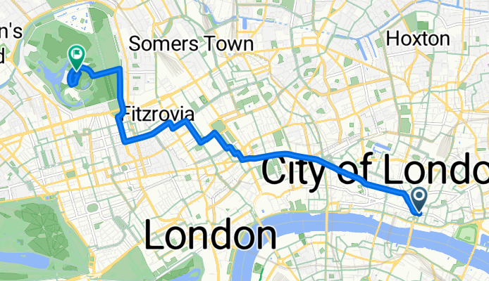
1 Thomas More St, London to Barnby St, London
Trasa rowerowa w City of London, Anglia, Zjednoczone Królestwo Wielkiej Brytanii
- 6,8 km
- Dystans
- 45 m
- Przewyższenia
- 30 m
- Spadek

139 Jamaica Road, London naar Gower St, London
Trasa rowerowa w City of London, Anglia, Zjednoczone Królestwo Wielkiej Brytanii
- 7,4 km
- Dystans
- 71 m
- Przewyższenia
- 36 m
- Spadek
Eastcheap, London à Inner Circle, London
Trasa rowerowa w City of London, Anglia, Zjednoczone Królestwo Wielkiej Brytanii
- 7,3 km
- Dystans
- 30 m
- Przewyższenia
- 7 m
- Spadek
1 Angel Lane, London to 112 St Pancras Way, London
Trasa rowerowa w City of London, Anglia, Zjednoczone Królestwo Wielkiej Brytanii
- 6,1 km
- Dystans
- 53 m
- Przewyższenia
- 21 m
- Spadek

130 Whitechapel High St, London to Bagshot House, Redhill St, London
Trasa rowerowa w City of London, Anglia, Zjednoczone Królestwo Wielkiej Brytanii
- 6,8 km
- Dystans
- 54 m
- Przewyższenia
- 41 m
- Spadek
Odkryj więcej tras
 pottery
- Dystans
- 7,2 km
- Przewyższenia
- 95 m
- Spadek
- 64 m
- Lokalizacja
- City of London, Anglia, Zjednoczone Królestwo Wielkiej Brytanii
 1 Aldgate, London to 1–7 Delancey St, London
- Dystans
- 6,4 km
- Przewyższenia
- 166 m
- Spadek
- 137 m
- Lokalizacja
- City of London, Anglia, Zjednoczone Królestwo Wielkiej Brytanii
 Aldgate Station, Aldgate High St, London to Bagshot House, Redhill St, London
- Dystans
- 6,1 km
- Przewyższenia
- 57 m
- Spadek
- 57 m
- Lokalizacja
- City of London, Anglia, Zjednoczone Królestwo Wielkiej Brytanii
 1 Thomas More St, London to Barnby St, London
- Dystans
- 6,8 km
- Przewyższenia
- 45 m
- Spadek
- 30 m
- Lokalizacja
- City of London, Anglia, Zjednoczone Królestwo Wielkiej Brytanii
 139 Jamaica Road, London naar Gower St, London
- Dystans
- 7,4 km
- Przewyższenia
- 71 m
- Spadek
- 36 m
- Lokalizacja
- City of London, Anglia, Zjednoczone Królestwo Wielkiej Brytanii
 Eastcheap, London à Inner Circle, London
- Dystans
- 7,3 km
- Przewyższenia
- 30 m
- Spadek
- 7 m
- Lokalizacja
- City of London, Anglia, Zjednoczone Królestwo Wielkiej Brytanii
 1 Angel Lane, London to 112 St Pancras Way, London
- Dystans
- 6,1 km
- Przewyższenia
- 53 m
- Spadek
- 21 m
- Lokalizacja
- City of London, Anglia, Zjednoczone Królestwo Wielkiej Brytanii
 130 Whitechapel High St, London to Bagshot House, Redhill St, London
- Dystans
- 6,8 km
- Przewyższenia
- 54 m
- Spadek
- 41 m
- Lokalizacja
- City of London, Anglia, Zjednoczone Królestwo Wielkiej Brytanii
Trasy z City of London
Jednodniowa wycieczka rowerowa od
Z City of London do Hinchley Wood
Rowerowa od
Z City of London do Brixton
Rowerowa od
Z City of London do Hackney
Trasy do Camden Town
Rowerowa od
Z Belsize Park do Camden Town
Rowerowa od
Z Holloway do Camden Town