
Jednodniowa wycieczka rowerowa z Inverness do Fort William
Dostosuj własną trasę na podstawie naszego szablonu lub zobacz, jak nasza społeczność najchętniej jeździ z Inverness do Fort William.
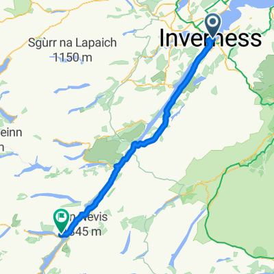
Szablon trasy
Z Inverness do Fort William

- 9 h 43 min
- Czas
- 118,3 km
- Dystans
- 1658 m
- Przewyższenia
- 1652 m
- Spadek
- 12,2 km/h
- Śr. Prędkość
- 386 m
- Maks. wysokość
Set off from Inverness, the “capital of the Highlands,” and enjoy a truly epic ride south to Fort William, known as the gateway to Ben Nevis—the UK’s highest mountain. This 118 km cycling adventure rolls through some of Scotland’s most legendary landscapes, with just over 1,650 meters of climbing to keep things interesting.
The route offers a real taste of Highland scenery: expect a mix of surfaces, from smooth asphalt and quiet roads to gravel and forest tracks. You’ll weave along sections of the famous Great Glen Way, hug the mysterious shores of Loch Ness (keep an eye out for Nessie!), and wind through pine forests and scenic glens.
It’s wild and remote in places—over half the route travels surfaces you won’t find in a city—but that’s part of the magic. Whether you’re fueling up in small villages or pausing to admire sweeping loch views, this is Scottish cycling at its dramatic best. End your ride in Fort William, the adventure capital of Scotland, where a hot meal and a well-earned rest await.
Wspólnota
Najlepsi użytkownicy w tym regionie


Od naszej społeczności
Najlepsze trasy rowerowe z Inverness do Fort William

From sea to sea , slicing Scotland
Trasa rowerowa w Inverness, Szkocja, Zjednoczone Królestwo Wielkiej Brytanii
- 108,4 km
- Dystans
- 297 m
- Przewyższenia
- 280 m
- Spadek

Great Glen Way
Trasa rowerowa w Inverness, Szkocja, Zjednoczone Królestwo Wielkiej Brytanii
- 120,1 km
- Dystans
- 1116 m
- Przewyższenia
- 1127 m
- Spadek

Great Glen (Bikemap algorithm)
Trasa rowerowa w Inverness, Szkocja, Zjednoczone Królestwo Wielkiej Brytanii
- 105,2 km
- Dystans
- 659 m
- Przewyższenia
- 669 m
- Spadek

Vuelta
Trasa rowerowa w Inverness, Szkocja, Zjednoczone Królestwo Wielkiej Brytanii
- 104,6 km
- Dystans
- 1089 m
- Przewyższenia
- 1090 m
- Spadek

Madras Cottage, 8 Telford Ave, Inverness to 43 Kennedy Road, Fort William
Trasa rowerowa w Inverness, Szkocja, Zjednoczone Królestwo Wielkiej Brytanii
- 106,3 km
- Dystans
- 1235 m
- Przewyższenia
- 1174 m
- Spadek

5/24 Inverness-Fort William
Trasa rowerowa w Inverness, Szkocja, Zjednoczone Królestwo Wielkiej Brytanii
- 101,5 km
- Dystans
- 630 m
- Przewyższenia
- 624 m
- Spadek

Escócia 6, Glencoe, fort William, Augustus, Inverness
Trasa rowerowa w Inverness, Szkocja, Zjednoczone Królestwo Wielkiej Brytanii
- 159,5 km
- Dystans
- 1839 m
- Przewyższenia
- 1855 m
- Spadek

Church Street 84 to Belford Road
Trasa rowerowa w Inverness, Szkocja, Zjednoczone Królestwo Wielkiej Brytanii
- 104,1 km
- Dystans
- 1181 m
- Przewyższenia
- 1180 m
- Spadek

Ben Nevis Challenge
Trasa rowerowa w Inverness, Szkocja, Zjednoczone Królestwo Wielkiej Brytanii
- 105,4 km
- Dystans
- 670 m
- Przewyższenia
- 638 m
- Spadek

Foyers-Fort William
Trasa rowerowa w Inverness, Szkocja, Zjednoczone Królestwo Wielkiej Brytanii
- 78,1 km
- Dystans
- 652 m
- Przewyższenia
- 661 m
- Spadek

Saturday 14th Inverness to Ft. William
Trasa rowerowa w Inverness, Szkocja, Zjednoczone Królestwo Wielkiej Brytanii
- 104,1 km
- Dystans
- 677 m
- Przewyższenia
- 662 m
- Spadek

inverness to glencoe. day day3
Trasa rowerowa w Inverness, Szkocja, Zjednoczone Królestwo Wielkiej Brytanii
- 132,8 km
- Dystans
- 725 m
- Przewyższenia
- 710 m
- Spadek
Odkryj więcej tras
 Madras Cottage, 8 Telford Ave, Inverness to 43 Kennedy Road, Fort William
- Dystans
- 106,3 km
- Przewyższenia
- 1235 m
- Spadek
- 1174 m
- Lokalizacja
- Inverness, Szkocja, Zjednoczone Królestwo Wielkiej Brytanii
 5/24 Inverness-Fort William
- Dystans
- 101,5 km
- Przewyższenia
- 630 m
- Spadek
- 624 m
- Lokalizacja
- Inverness, Szkocja, Zjednoczone Królestwo Wielkiej Brytanii
 Escócia 6, Glencoe, fort William, Augustus, Inverness
- Dystans
- 159,5 km
- Przewyższenia
- 1839 m
- Spadek
- 1855 m
- Lokalizacja
- Inverness, Szkocja, Zjednoczone Królestwo Wielkiej Brytanii
 Church Street 84 to Belford Road
- Dystans
- 104,1 km
- Przewyższenia
- 1181 m
- Spadek
- 1180 m
- Lokalizacja
- Inverness, Szkocja, Zjednoczone Królestwo Wielkiej Brytanii
 Ben Nevis Challenge
- Dystans
- 105,4 km
- Przewyższenia
- 670 m
- Spadek
- 638 m
- Lokalizacja
- Inverness, Szkocja, Zjednoczone Królestwo Wielkiej Brytanii
 Foyers-Fort William
- Dystans
- 78,1 km
- Przewyższenia
- 652 m
- Spadek
- 661 m
- Lokalizacja
- Inverness, Szkocja, Zjednoczone Królestwo Wielkiej Brytanii
 Saturday 14th Inverness to Ft. William
- Dystans
- 104,1 km
- Przewyższenia
- 677 m
- Spadek
- 662 m
- Lokalizacja
- Inverness, Szkocja, Zjednoczone Królestwo Wielkiej Brytanii
 inverness to glencoe. day day3
- Dystans
- 132,8 km
- Przewyższenia
- 725 m
- Spadek
- 710 m
- Lokalizacja
- Inverness, Szkocja, Zjednoczone Królestwo Wielkiej Brytanii
Trasy do Fort William
Jednodniowa wycieczka rowerowa od
Z Oban do Fort William