
Rowerowa z Hackney do Bethnal Green
Dostosuj własną trasę na podstawie naszego szablonu lub zobacz, jak nasza społeczność najchętniej jeździ z Hackney do Bethnal Green.
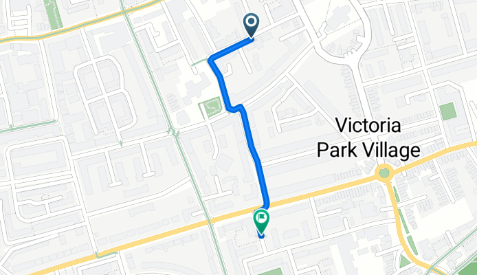
Szablon trasy
Z Hackney do Bethnal Green

- 14 min
- Czas
- 4 km
- Dystans
- 11 m
- Przewyższenia
- 10 m
- Spadek
- 17,8 km/h
- Śr. Prędkość
- 23 m
- Maks. wysokość
This pleasant bike ride takes you from Hackney down to Bethnal Green, covering just over 4 km on mostly quiet, paved roads—making it ideal for a relaxed commute or a scenic detour. You’ll start out in vibrant Hackney, known for its lively markets, art spaces, and buzzing cafes. From there, pedal south on tranquil residential streets, with gentle ups and downs and almost no busy road exposure. Most of the route sticks to smooth asphalt, with just a hint of paving stones to keep things interesting.
The journey wraps up in Bethnal Green, a neighborhood famous for the V&A Museum of Childhood and its classic East End vibe. With parks, indie shops, and historic pubs all around, it’s a great area to explore after your ride. Whether you’re cycling to meet friends, check out some street art, or just enjoy the London air, this route promises an easygoing trip through some of East London’s best spots.
Wspólnota
Najlepsi użytkownicy w tym regionie


Od naszej społeczności
Najlepsze trasy rowerowe z Hackney do Bethnal Green
Victoria Park Court, London to Rutland Road, London
Trasa rowerowa w Hackney, Anglia, Zjednoczone Królestwo Wielkiej Brytanii
- 0,8 km
- Dystans
- 4 m
- Przewyższenia
- 0 m
- Spadek

Sonntags-Jogging
Trasa rowerowa w Hackney, Anglia, Zjednoczone Królestwo Wielkiej Brytanii
- 17,4 km
- Dystans
- 33 m
- Przewyższenia
- 25 m
- Spadek

Stratford International to London Fields
Trasa rowerowa w Hackney, Anglia, Zjednoczone Królestwo Wielkiej Brytanii
- 4,9 km
- Dystans
- 33 m
- Przewyższenia
- 16 m
- Spadek

21 Oldfield Road, London to 131 Mare Street, London
Trasa rowerowa w Hackney, Anglia, Zjednoczone Królestwo Wielkiej Brytanii
- 4,6 km
- Dystans
- 34 m
- Przewyższenia
- 42 m
- Spadek

52 Stoke Newington High Street, London to 131 Mare Street, London
Trasa rowerowa w Hackney, Anglia, Zjednoczone Królestwo Wielkiej Brytanii
- 4,3 km
- Dystans
- 19 m
- Przewyższenia
- 44 m
- Spadek

47A Barbauld Road, London to 131 Mare Street, London
Trasa rowerowa w Hackney, Anglia, Zjednoczone Królestwo Wielkiej Brytanii
- 3,7 km
- Dystans
- 24 m
- Przewyższenia
- 30 m
- Spadek

68 Kingsland High Street, London to 131 Mare Street, London
Trasa rowerowa w Hackney, Anglia, Zjednoczone Królestwo Wielkiej Brytanii
- 2,9 km
- Dystans
- 13 m
- Przewyższenia
- 30 m
- Spadek

Stoke Newington Common 7 to Cambridge Heath Road 282
Trasa rowerowa w Hackney, Anglia, Zjednoczone Królestwo Wielkiej Brytanii
- 4,5 km
- Dystans
- 4 m
- Przewyższenia
- 9 m
- Spadek

Chatsworth Road 147 to Goldsmiths Row 40
Trasa rowerowa w Hackney, Anglia, Zjednoczone Królestwo Wielkiej Brytanii
- 4,5 km
- Dystans
- 15 m
- Przewyższenia
- 48 m
- Spadek

18 Yeter House, Helmsley Pl, London to 54 Folgate St, London
Trasa rowerowa w Hackney, Anglia, Zjednoczone Królestwo Wielkiej Brytanii
- 2,9 km
- Dystans
- 32 m
- Przewyższenia
- 62 m
- Spadek

Recovered Route
Trasa rowerowa w Hackney, Anglia, Zjednoczone Królestwo Wielkiej Brytanii
- 1,9 km
- Dystans
- 13 m
- Przewyższenia
- 3 m
- Spadek

3 Martel Pl, London to 1–51 Squirries St, London
Trasa rowerowa w Hackney, Anglia, Zjednoczone Królestwo Wielkiej Brytanii
- 2,7 km
- Dystans
- 15 m
- Przewyższenia
- 20 m
- Spadek
Odkryj więcej tras
 52 Stoke Newington High Street, London to 131 Mare Street, London
- Dystans
- 4,3 km
- Przewyższenia
- 19 m
- Spadek
- 44 m
- Lokalizacja
- Hackney, Anglia, Zjednoczone Królestwo Wielkiej Brytanii
 47A Barbauld Road, London to 131 Mare Street, London
- Dystans
- 3,7 km
- Przewyższenia
- 24 m
- Spadek
- 30 m
- Lokalizacja
- Hackney, Anglia, Zjednoczone Królestwo Wielkiej Brytanii
 68 Kingsland High Street, London to 131 Mare Street, London
- Dystans
- 2,9 km
- Przewyższenia
- 13 m
- Spadek
- 30 m
- Lokalizacja
- Hackney, Anglia, Zjednoczone Królestwo Wielkiej Brytanii
 Stoke Newington Common 7 to Cambridge Heath Road 282
- Dystans
- 4,5 km
- Przewyższenia
- 4 m
- Spadek
- 9 m
- Lokalizacja
- Hackney, Anglia, Zjednoczone Królestwo Wielkiej Brytanii
 Chatsworth Road 147 to Goldsmiths Row 40
- Dystans
- 4,5 km
- Przewyższenia
- 15 m
- Spadek
- 48 m
- Lokalizacja
- Hackney, Anglia, Zjednoczone Królestwo Wielkiej Brytanii
 18 Yeter House, Helmsley Pl, London to 54 Folgate St, London
- Dystans
- 2,9 km
- Przewyższenia
- 32 m
- Spadek
- 62 m
- Lokalizacja
- Hackney, Anglia, Zjednoczone Królestwo Wielkiej Brytanii
 Recovered Route
- Dystans
- 1,9 km
- Przewyższenia
- 13 m
- Spadek
- 3 m
- Lokalizacja
- Hackney, Anglia, Zjednoczone Królestwo Wielkiej Brytanii
 3 Martel Pl, London to 1–51 Squirries St, London
- Dystans
- 2,7 km
- Przewyższenia
- 15 m
- Spadek
- 20 m
- Lokalizacja
- Hackney, Anglia, Zjednoczone Królestwo Wielkiej Brytanii
Trasy z Hackney
Rowerowa od
Z Hackney do Clerkenwell
Rowerowa od
Z Hackney do City of London
Trasy do Bethnal Green
Rowerowa od
Z Poplar do Bethnal Green
Rowerowa od
Z Londyn do Bethnal Green