
Szablon trasy
Z Colinton do Currie
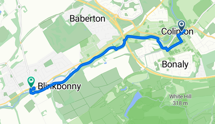
- 16 min
- Czas
- 4,7 km
- Dystans
- 63 m
- Przewyższenia
- 30 m
- Spadek
- 17,1 km/h
- Śr. Prędkość
- 148 m
- Maks. wysokość
This is a lovely little ride linking the leafy suburb of Colinton with the village of Currie, tucked along the Water of Leith to Edinburgh’s southwest. The route is just under 5 km and travels mostly on paved surfaces, with the majority being dedicated cycleways—perfect for a relaxed outing or a quiet daily commute.
Starting in Colinton, known for its historic viaduct and connections to poet Robert Louis Stevenson, you’ll roll through green, gently undulating paths with an easy climb or two but nothing too taxing. Much of the way follows the Water of Leith Walkway, so you’ll get to enjoy a peaceful, traffic-free experience with plenty of trees overhead.
As you arrive in Currie, you’ll notice its charming village vibe and maybe catch a glimpse of the old Currie Kirk. The descent into Currie is quite gentle, so it’s a great spot to catch your breath and perhaps grab a coffee.
All in all, it’s a friendly route for riders of most abilities, ideal for anyone wanting a scenic break from city streets.
Wspólnota
Najlepsi użytkownicy w tym regionie


Od naszej społeczności
Najlepsze trasy rowerowe z Colinton do Currie

Estuary Circuit
Trasa rowerowa w Colinton, Szkocja, Zjednoczone Królestwo Wielkiej Brytanii
- 106,3 km
- Dystans
- 486 m
- Przewyższenia
- 471 m
- Spadek

Whec Heriot Watt Currie loop
Trasa rowerowa w Colinton, Szkocja, Zjednoczone Królestwo Wielkiej Brytanii
- 21,1 km
- Dystans
- 128 m
- Przewyższenia
- 108 m
- Spadek

Christmas run
Trasa rowerowa w Colinton, Szkocja, Zjednoczone Królestwo Wielkiej Brytanii
- 63,9 km
- Dystans
- 482 m
- Przewyższenia
- 446 m
- Spadek

16/04/19
Trasa rowerowa w Colinton, Szkocja, Zjednoczone Królestwo Wielkiej Brytanii
- 55 km
- Dystans
- 446 m
- Przewyższenia
- 442 m
- Spadek

22D Oxgangs Ave, Edinburgh to 58 Lanark Road W, Currie
Trasa rowerowa w Colinton, Szkocja, Zjednoczone Królestwo Wielkiej Brytanii
- 6,1 km
- Dystans
- 117 m
- Przewyższenia
- 96 m
- Spadek

22D Oxgangs Ave, Edinburgh to 57 Lanark Road W, Currie
Trasa rowerowa w Colinton, Szkocja, Zjednoczone Królestwo Wielkiej Brytanii
- 5,7 km
- Dystans
- 201 m
- Przewyższenia
- 185 m
- Spadek

1 Oxgangs Rise, Edinburgh to 60 Lanark Road W, Currie
Trasa rowerowa w Colinton, Szkocja, Zjednoczone Królestwo Wielkiej Brytanii
- 5,6 km
- Dystans
- 127 m
- Przewyższenia
- 110 m
- Spadek

22D Oxgangs Ave, Edinburgh to 23 Provost Haugh, Currie
Trasa rowerowa w Colinton, Szkocja, Zjednoczone Królestwo Wielkiej Brytanii
- 6,1 km
- Dystans
- 98 m
- Przewyższenia
- 87 m
- Spadek

22D Oxgangs Ave, Edinburgh to 23 Provost Haugh, Currie
Trasa rowerowa w Colinton, Szkocja, Zjednoczone Królestwo Wielkiej Brytanii
- 5,6 km
- Dystans
- 89 m
- Przewyższenia
- 71 m
- Spadek

22D Oxgangs Ave, Edinburgh to 57 Lanark Road W, Currie
Trasa rowerowa w Colinton, Szkocja, Zjednoczone Królestwo Wielkiej Brytanii
- 5,6 km
- Dystans
- 203 m
- Przewyższenia
- 185 m
- Spadek

Lengthy ride through Edynburg
Trasa rowerowa w Colinton, Szkocja, Zjednoczone Królestwo Wielkiej Brytanii
- 63,4 km
- Dystans
- 168 m
- Przewyższenia
- 182 m
- Spadek
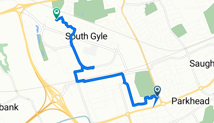
3 Broomview Path, Edinburgh to 343–349 Gyle Ave, Edinburgh
Trasa rowerowa w Colinton, Szkocja, Zjednoczone Królestwo Wielkiej Brytanii
- 4,1 km
- Dystans
- 0 m
- Przewyższenia
- 48 m
- Spadek
Odkryj więcej tras
 22D Oxgangs Ave, Edinburgh to 58 Lanark Road W, Currie
- Dystans
- 6,1 km
- Przewyższenia
- 117 m
- Spadek
- 96 m
- Lokalizacja
- Colinton, Szkocja, Zjednoczone Królestwo Wielkiej Brytanii
 22D Oxgangs Ave, Edinburgh to 57 Lanark Road W, Currie
- Dystans
- 5,7 km
- Przewyższenia
- 201 m
- Spadek
- 185 m
- Lokalizacja
- Colinton, Szkocja, Zjednoczone Królestwo Wielkiej Brytanii
 1 Oxgangs Rise, Edinburgh to 60 Lanark Road W, Currie
- Dystans
- 5,6 km
- Przewyższenia
- 127 m
- Spadek
- 110 m
- Lokalizacja
- Colinton, Szkocja, Zjednoczone Królestwo Wielkiej Brytanii
 22D Oxgangs Ave, Edinburgh to 23 Provost Haugh, Currie
- Dystans
- 6,1 km
- Przewyższenia
- 98 m
- Spadek
- 87 m
- Lokalizacja
- Colinton, Szkocja, Zjednoczone Królestwo Wielkiej Brytanii
 22D Oxgangs Ave, Edinburgh to 23 Provost Haugh, Currie
- Dystans
- 5,6 km
- Przewyższenia
- 89 m
- Spadek
- 71 m
- Lokalizacja
- Colinton, Szkocja, Zjednoczone Królestwo Wielkiej Brytanii
 22D Oxgangs Ave, Edinburgh to 57 Lanark Road W, Currie
- Dystans
- 5,6 km
- Przewyższenia
- 203 m
- Spadek
- 185 m
- Lokalizacja
- Colinton, Szkocja, Zjednoczone Królestwo Wielkiej Brytanii
 Lengthy ride through Edynburg
- Dystans
- 63,4 km
- Przewyższenia
- 168 m
- Spadek
- 182 m
- Lokalizacja
- Colinton, Szkocja, Zjednoczone Królestwo Wielkiej Brytanii
 3 Broomview Path, Edinburgh to 343–349 Gyle Ave, Edinburgh
- Dystans
- 4,1 km
- Przewyższenia
- 0 m
- Spadek
- 48 m
- Lokalizacja
- Colinton, Szkocja, Zjednoczone Królestwo Wielkiej Brytanii
Trasy z Colinton
Szybka przejażdżka rowerowa od
Z Colinton do Edynburg