
Szybka przejażdżka rowerowa z Tägerwilen do Kreuzlingen
Dostosuj własną trasę na podstawie naszego szablonu lub zobacz, jak nasza społeczność najchętniej jeździ z Tägerwilen do Kreuzlingen.
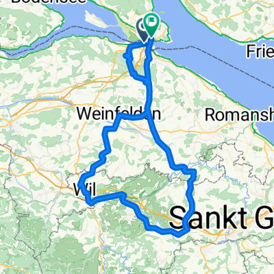
Szablon trasy
Z Tägerwilen do Kreuzlingen

- 16 min
- Czas
- 4,7 km
- Dystans
- 15 m
- Przewyższenia
- 11 m
- Spadek
- 17,6 km/h
- Śr. Prędkość
- 414 m
- Maks. wysokość
This is a short and pleasant ride starting in Tägerwilen and finishing in Kreuzlingen, perfect for a relaxed afternoon spin. Tägerwilen is a laid-back Swiss village right by the border, while Kreuzlingen sits on the shores of beautiful Lake Constance and is known for its public parks and vibrant lakeside promenade.
The 4.7 km route takes around 25-30 minutes at an easy pace and mostly follows smooth asphalt and paved paths — ideal for any bike. It’s just a gently rolling ride, so there’s hardly any climbing to worry about. You’ll spend much of the way on quiet roads, scenic paths, and a bit of gravel for a touch of variety.
As you arrive in Kreuzlingen, consider exploring Seeburgpark or checking out the lively Hafenstrasse. Whether you’re just commuting or enjoying a scenic outing, this route offers a simple, safe way to connect two lovely Swiss towns.
Wspólnota
Najlepsi użytkownicy w tym regionie


Od naszej społeczności
Najlepsze trasy rowerowe z Tägerwilen do Kreuzlingen

Rund um Weinfelden
Trasa rowerowa w Tägerwilen, Turgowia, Szwajcaria
- 64 km
- Dystans
- 686 m
- Przewyższenia
- 627 m
- Spadek

Schweiz 19.08.2010
Trasa rowerowa w Tägerwilen, Turgowia, Szwajcaria
- 21,8 km
- Dystans
- 290 m
- Przewyższenia
- 282 m
- Spadek

test thurgau
Trasa rowerowa w Tägerwilen, Turgowia, Szwajcaria
- 45,5 km
- Dystans
- 279 m
- Przewyższenia
- 296 m
- Spadek

Untersee Hugeln
Trasa rowerowa w Tägerwilen, Turgowia, Szwajcaria
- 109 km
- Dystans
- 1090 m
- Przewyższenia
- 1090 m
- Spadek

KN-Ottenberg-Weinfelden-Amlikon-Braunauer Höhe
Trasa rowerowa w Tägerwilen, Turgowia, Szwajcaria
- 58,3 km
- Dystans
- 815 m
- Przewyższenia
- 813 m
- Spadek

Konstanz-Weinfelden-Berg
Trasa rowerowa w Tägerwilen, Turgowia, Szwajcaria
- 38,4 km
- Dystans
- 317 m
- Przewyższenia
- 232 m
- Spadek


Seerücken, Untersee und Hegau
Trasa rowerowa w Tägerwilen, Turgowia, Szwajcaria
- 72,6 km
- Dystans
- 407 m
- Przewyższenia
- 405 m
- Spadek

Mittlere Runde Thurgau
Trasa rowerowa w Tägerwilen, Turgowia, Szwajcaria
- 50,3 km
- Dystans
- 196 m
- Przewyższenia
- 193 m
- Spadek

Romanshorn
Trasa rowerowa w Tägerwilen, Turgowia, Szwajcaria
- 47,2 km
- Dystans
- 87 m
- Przewyższenia
- 87 m
- Spadek

Konstanz - Herisau - Wil - Konstanz
Trasa rowerowa w Tägerwilen, Turgowia, Szwajcaria
- 95,2 km
- Dystans
- 827 m
- Przewyższenia
- 760 m
- Spadek

GRosse Runde mit Freddy
Trasa rowerowa w Tägerwilen, Turgowia, Szwajcaria
- 55,3 km
- Dystans
- 604 m
- Przewyższenia
- 604 m
- Spadek
Odkryj więcej tras
 KN-Ottenberg-Weinfelden-Amlikon-Braunauer Höhe
- Dystans
- 58,3 km
- Przewyższenia
- 815 m
- Spadek
- 813 m
- Lokalizacja
- Tägerwilen, Turgowia, Szwajcaria
 Konstanz-Weinfelden-Berg
- Dystans
- 38,4 km
- Przewyższenia
- 317 m
- Spadek
- 232 m
- Lokalizacja
- Tägerwilen, Turgowia, Szwajcaria
 05-2021
- Dystans
- 41,5 km
- Przewyższenia
- 300 m
- Spadek
- 298 m
- Lokalizacja
- Tägerwilen, Turgowia, Szwajcaria
 Seerücken, Untersee und Hegau
- Dystans
- 72,6 km
- Przewyższenia
- 407 m
- Spadek
- 405 m
- Lokalizacja
- Tägerwilen, Turgowia, Szwajcaria
 Mittlere Runde Thurgau
- Dystans
- 50,3 km
- Przewyższenia
- 196 m
- Spadek
- 193 m
- Lokalizacja
- Tägerwilen, Turgowia, Szwajcaria
 Romanshorn
- Dystans
- 47,2 km
- Przewyższenia
- 87 m
- Spadek
- 87 m
- Lokalizacja
- Tägerwilen, Turgowia, Szwajcaria
 Konstanz - Herisau - Wil - Konstanz
- Dystans
- 95,2 km
- Przewyższenia
- 827 m
- Spadek
- 760 m
- Lokalizacja
- Tägerwilen, Turgowia, Szwajcaria
 GRosse Runde mit Freddy
- Dystans
- 55,3 km
- Przewyższenia
- 604 m
- Spadek
- 604 m
- Lokalizacja
- Tägerwilen, Turgowia, Szwajcaria
Trasy do Kreuzlingen
Jednodniowa wycieczka rowerowa od
Z Überlingen do Kreuzlingen
Jednodniowa wycieczka rowerowa od
Z Romanshorn do Kreuzlingen
Szybka przejażdżka rowerowa od
Z Konstancja do Kreuzlingen