
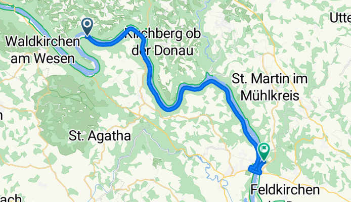
Jednodniowa wycieczka rowerowa z Pfarrkirchen im Mühlkreis do Feldkirchen an der Donau
Dostosuj własną trasę na podstawie naszego szablonu lub zobacz, jak nasza społeczność najchętniej jeździ z Pfarrkirchen im Mühlkreis do Feldkirchen an der Donau.
Szablon trasy
Z Pfarrkirchen im Mühlkreis do Feldkirchen an der Donau

- 2 h 11 min
- Czas
- 34 km
- Dystans
- 374 m
- Przewyższenia
- 922 m
- Spadek
- 15,5 km/h
- Śr. Prędkość
- 818 m
- Maks. wysokość
This scenic cycling route takes you from the pretty hilltop village of Pfarrkirchen im Mühlkreis down to Feldkirchen an der Donau, nestled alongside the famous Danube River. Starting at almost 820 meters above sea level, you’ll enjoy some gentle climbs before a long and rewarding descent—over 900 meters down! Expect a mix of quiet country roads and some smooth cycleways, so it's mostly peaceful riding with minimal traffic.
About half the route’s surface isn’t specified, but you’ll find plenty of good asphalt stretches, ideal for trekking or road bikes. Pfarrkirchen has stunning views over the Mühlviertel, making the start of your trip particularly memorable. As you roll into Feldkirchen, consider a dip in one of the area’s natural lakes or explore the riverside. At just over 34 kilometers, it’s a classic Mühlviertel to Danube ride—rolling landscapes, forested corners, and picturesque villages included!
Wspólnota
Najlepsi użytkownicy w tym regionie


Od naszej społeczności
Najlepsze trasy rowerowe z Pfarrkirchen im Mühlkreis do Feldkirchen an der Donau
Pfarrkirchen im Mühlkreis - Feldkirchen an der Donau
Trasa rowerowa w Pfarrkirchen im Mühlkreis, Górna Austria, Austria
- 24,5 km
- Dystans
- 650 m
- Przewyższenia
- 644 m
- Spadek
Niederranna bis Aschach
Trasa rowerowa w Pfarrkirchen im Mühlkreis, Górna Austria, Austria
- 38,3 km
- Dystans
- 294 m
- Przewyższenia
- 306 m
- Spadek

Lange Ausfahrt von Hofkirchen im Mühlkreis nach Aschach an der Donau
Trasa rowerowa w Pfarrkirchen im Mühlkreis, Górna Austria, Austria
- 33,1 km
- Dystans
- 310 m
- Przewyższenia
- 329 m
- Spadek

Viechtenstein - Wilhering 2
Trasa rowerowa w Pfarrkirchen im Mühlkreis, Górna Austria, Austria
- 56,7 km
- Dystans
- 328 m
- Przewyższenia
- 658 m
- Spadek

2023 - Engelhartszell - Untermühl - Brandstatt (Alternative gesperrter Radweg bei Kobling
Trasa rowerowa w Pfarrkirchen im Mühlkreis, Górna Austria, Austria
- 50,8 km
- Dystans
- 563 m
- Przewyższenia
- 583 m
- Spadek

Niederranna 59 to Abelstraße 46, Aschach an der Donau
Trasa rowerowa w Pfarrkirchen im Mühlkreis, Górna Austria, Austria
- 34,5 km
- Dystans
- 912 m
- Przewyższenia
- 925 m
- Spadek

2023 Tag - Day 2 Engelhartszell - Untermühl -Brandstatt violette - violet Route, ca. 51 km
Trasa rowerowa w Pfarrkirchen im Mühlkreis, Górna Austria, Austria
- 51 km
- Dystans
- 556 m
- Przewyższenia
- 571 m
- Spadek

2018_Römer RW 3b.Et.Kasten-Hartkirchen
Trasa rowerowa w Pfarrkirchen im Mühlkreis, Górna Austria, Austria
- 36 km
- Dystans
- 381 m
- Przewyższenia
- 403 m
- Spadek

Passau - Wien 1
Trasa rowerowa w Pfarrkirchen im Mühlkreis, Górna Austria, Austria
- 44 km
- Dystans
- 621 m
- Przewyższenia
- 643 m
- Spadek

2024 - Engelhartszell - Aschach, ca. 46 km
Trasa rowerowa w Pfarrkirchen im Mühlkreis, Górna Austria, Austria
- 45,6 km
- Dystans
- 519 m
- Przewyższenia
- 534 m
- Spadek

Freizell 8, Hofkirchen im Mühlkreis nach Donausteig Passau-Linz-St Nikola, Aschach an der Donau
Trasa rowerowa w Pfarrkirchen im Mühlkreis, Górna Austria, Austria
- 75,7 km
- Dystans
- 400 m
- Przewyższenia
- 413 m
- Spadek

Engelhartszell-Eferding
Trasa rowerowa w Pfarrkirchen im Mühlkreis, Górna Austria, Austria
- 48,3 km
- Dystans
- 196 m
- Przewyższenia
- 211 m
- Spadek
Odkryj więcej tras
 2023 - Engelhartszell - Untermühl - Brandstatt (Alternative gesperrter Radweg bei Kobling
- Dystans
- 50,8 km
- Przewyższenia
- 563 m
- Spadek
- 583 m
- Lokalizacja
- Pfarrkirchen im Mühlkreis, Górna Austria, Austria
 Niederranna 59 to Abelstraße 46, Aschach an der Donau
- Dystans
- 34,5 km
- Przewyższenia
- 912 m
- Spadek
- 925 m
- Lokalizacja
- Pfarrkirchen im Mühlkreis, Górna Austria, Austria
 2023 Tag - Day 2 Engelhartszell - Untermühl -Brandstatt violette - violet Route, ca. 51 km
- Dystans
- 51 km
- Przewyższenia
- 556 m
- Spadek
- 571 m
- Lokalizacja
- Pfarrkirchen im Mühlkreis, Górna Austria, Austria
 2018_Römer RW 3b.Et.Kasten-Hartkirchen
- Dystans
- 36 km
- Przewyższenia
- 381 m
- Spadek
- 403 m
- Lokalizacja
- Pfarrkirchen im Mühlkreis, Górna Austria, Austria
 Passau - Wien 1
- Dystans
- 44 km
- Przewyższenia
- 621 m
- Spadek
- 643 m
- Lokalizacja
- Pfarrkirchen im Mühlkreis, Górna Austria, Austria
 2024 - Engelhartszell - Aschach, ca. 46 km
- Dystans
- 45,6 km
- Przewyższenia
- 519 m
- Spadek
- 534 m
- Lokalizacja
- Pfarrkirchen im Mühlkreis, Górna Austria, Austria
 Freizell 8, Hofkirchen im Mühlkreis nach Donausteig Passau-Linz-St Nikola, Aschach an der Donau
- Dystans
- 75,7 km
- Przewyższenia
- 400 m
- Spadek
- 413 m
- Lokalizacja
- Pfarrkirchen im Mühlkreis, Górna Austria, Austria
 Engelhartszell-Eferding
- Dystans
- 48,3 km
- Przewyższenia
- 196 m
- Spadek
- 211 m
- Lokalizacja
- Pfarrkirchen im Mühlkreis, Górna Austria, Austria
Trasy z Pfarrkirchen im Mühlkreis
Jednodniowa wycieczka rowerowa od
Z Pfarrkirchen im Mühlkreis do Kleinzell im Mühlkreis
Jednodniowa wycieczka rowerowa od
Z Pfarrkirchen im Mühlkreis do Ottensheim
Rowerowa od
Z Pfarrkirchen im Mühlkreis do Atzesberg
Trasy do Feldkirchen an der Donau
Jednodniowa wycieczka rowerowa od
Z Schärding do Feldkirchen an der Donau
Jednodniowa wycieczka rowerowa od
Z Pasawa do Feldkirchen an der Donau