
Szablon trasy
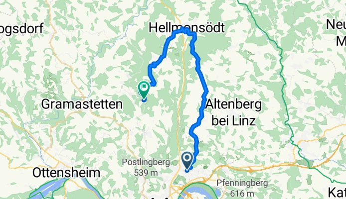
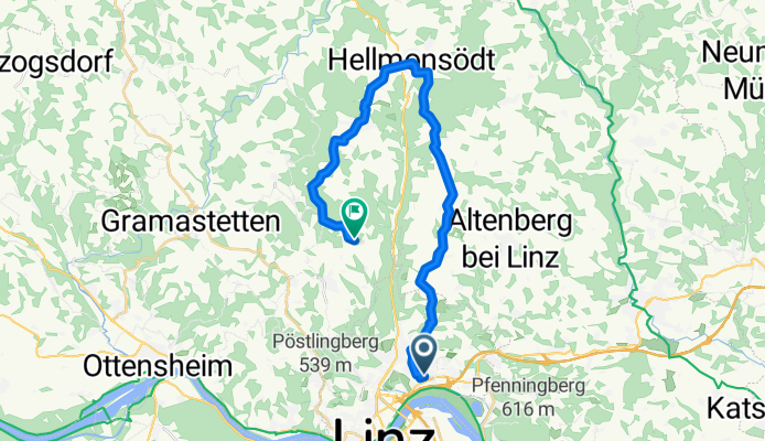
Z Linz do Eidenberg

- 1 h 36 min
- Czas
- 23,8 km
- Dystans
- 661 m
- Przewyższenia
- 253 m
- Spadek
- 14,8 km/h
- Śr. Prędkość
- 685 m
- Maks. wysokość
If you’re up for a climb and some beautiful Austrian countryside, this ride from Linz to Eidenberg is a fantastic choice! Your adventure kicks off in Linz, a vibrant city on the Danube known for its mix of modern culture and historic charm. As you leave the city behind, you’ll gradually head north into rural Upper Austria.
It’s about 24 km, but don’t be fooled by the distance—the route packs in a solid 660 m ascent, so get ready to spin those legs! Most of the way, you’ll enjoy quiet roads and some dedicated cycleways, making for a peaceful (and mostly traffic-free) ride. The surface is a mix, but nearly 40% is nice, smooth asphalt, which is great for rolling along.
As you climb, you’ll pass through lush fields and forests, with plenty of chances to pause and take in fantastic views—even more rewarding once you reach the max elevation near 685 meters. The endpoint in Eidenberg is a sleepy village nestled in the hills, perfect for unwinding after the effort. All in all, a short but punchy ride with a great blend of city and countryside!
Wspólnota
Najlepsi użytkownicy w tym regionie


Od naszej społeczności
Najlepsze trasy rowerowe z Linz do Eidenberg

Dießenleitental-Gis
Trasa rowerowa w Linz, Górna Austria, Austria
- 10,2 km
- Dystans
- 663 m
- Przewyższenia
- 46 m
- Spadek

GH Lindbauer_Höllmühlstr_Gis
Trasa rowerowa w Linz, Górna Austria, Austria
- 10,6 km
- Dystans
- 646 m
- Przewyższenia
- 19 m
- Spadek

Harbach Gis Nr.5
Trasa rowerowa w Linz, Górna Austria, Austria
- 10,4 km
- Dystans
- 650 m
- Przewyższenia
- 28 m
- Spadek

160er-Hellmonsödt-Kirchschlag-Gis
Trasa rowerowa w Linz, Górna Austria, Austria
- 23,2 km
- Dystans
- 958 m
- Przewyższenia
- 333 m
- Spadek

Auberg - Gis
Trasa rowerowa w Linz, Górna Austria, Austria
- 11,6 km
- Dystans
- 757 m
- Przewyższenia
- 115 m
- Spadek

Koglerauerspitz GIS
Trasa rowerowa w Linz, Górna Austria, Austria
- 16,6 km
- Dystans
- 798 m
- Przewyższenia
- 163 m
- Spadek

GIS über Pöstlingberg
Trasa rowerowa w Linz, Górna Austria, Austria
- 18,9 km
- Dystans
- 799 m
- Przewyższenia
- 174 m
- Spadek

Panoramastüberl 109er
Trasa rowerowa w Linz, Górna Austria, Austria
- 11 km
- Dystans
- 517 m
- Przewyższenia
- 71 m
- Spadek

GIS MTB über Linz Hauptplatz
Trasa rowerowa w Linz, Górna Austria, Austria
- 11,7 km
- Dystans
- ---
- Przewyższenia
- ---
- Spadek

GIS Normstrecke 2007
Trasa rowerowa w Linz, Górna Austria, Austria
- 10,7 km
- Dystans
- 661 m
- Przewyższenia
- 126 m
- Spadek
GIS über Oberbairing-Hellmonsödt
Trasa rowerowa w Linz, Górna Austria, Austria
- 26,6 km
- Dystans
- 882 m
- Przewyższenia
- 444 m
- Spadek
Odkryj więcej tras
 160er-Hellmonsödt-Kirchschlag-Gis
- Dystans
- 23,2 km
- Przewyższenia
- 958 m
- Spadek
- 333 m
- Lokalizacja
- Linz, Górna Austria, Austria
 Auberg - Gis
- Dystans
- 11,6 km
- Przewyższenia
- 757 m
- Spadek
- 115 m
- Lokalizacja
- Linz, Górna Austria, Austria
 Koglerauerspitz GIS
- Dystans
- 16,6 km
- Przewyższenia
- 798 m
- Spadek
- 163 m
- Lokalizacja
- Linz, Górna Austria, Austria
 GIS über Pöstlingberg
- Dystans
- 18,9 km
- Przewyższenia
- 799 m
- Spadek
- 174 m
- Lokalizacja
- Linz, Górna Austria, Austria
 Panoramastüberl 109er
- Dystans
- 11 km
- Przewyższenia
- 517 m
- Spadek
- 71 m
- Lokalizacja
- Linz, Górna Austria, Austria
 GIS MTB über Linz Hauptplatz
- Dystans
- 11,7 km
- Przewyższenia
- ---
- Spadek
- ---
- Lokalizacja
- Linz, Górna Austria, Austria
 GIS Normstrecke 2007
- Dystans
- 10,7 km
- Przewyższenia
- 661 m
- Spadek
- 126 m
- Lokalizacja
- Linz, Górna Austria, Austria
 GIS über Oberbairing-Hellmonsödt
- Dystans
- 26,6 km
- Przewyższenia
- 882 m
- Spadek
- 444 m
- Lokalizacja
- Linz, Górna Austria, Austria
Trasy z Linz
Bikepacking od
Z Linz do Salzburg
Jednodniowa wycieczka rowerowa od
Z Linz do Ennsdorf
Jednodniowa wycieczka rowerowa od
Z Linz do Emmersdorf an der Donau
Rowerowa od
Z Linz do Leonding
Rowerowa od
Z Linz do Steyregg