
Szablon trasy
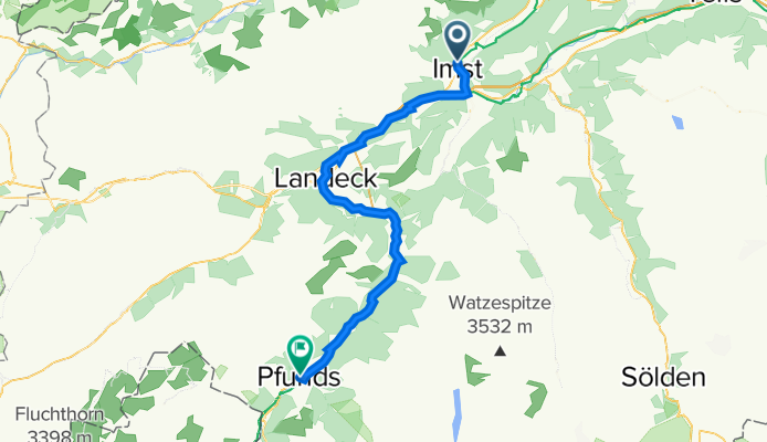
Z Imst do Pfunds

- 3 h 26 min
- Czas
- 54,7 km
- Dystans
- 1260 m
- Przewyższenia
- 1042 m
- Spadek
- 15,9 km/h
- Śr. Prędkość
- 1040 m
- Maks. wysokość
This is a fantastic ride starting in Imst, a lively town known for its beautiful gorges and historic architecture in the heart of Tyrol. From there, you’ll pedal south for just under 55 kilometers, heading toward Pfunds, a charming village nestled near the Swiss and Italian borders.
The route mostly follows paved roads (about 95%), so it’s great for road bikes—though you’ll hit a few stretches of gravel and unpaved paths to keep things interesting. Expect a good bit of climbing, with an ascent of over 1,250 meters; legs and lungs will be working, but you’ll be rewarded with awesome mountain views and smooth descents.
Much of your ride is on quiet country roads (44%) and tracks (24%), so it’s generally relaxed and scenic, with a few short sections on busier roads. Once you arrive in Pfunds, take some time to explore its traditional alpine streets and maybe grab a well-deserved pastry! This route really shows off the best of Tyrolean cycling—challenging but super scenic.
Wspólnota
Najlepsi użytkownicy w tym regionie


Od naszej społeczności
Najlepsze trasy rowerowe z Imst do Pfunds


2. Etappe 18.07.2021 Imst nach Pfunds
Trasa rowerowa w Imst, Tyrol, Austria
- 55,4 km
- Dystans
- 420 m
- Przewyższenia
- 258 m
- Spadek


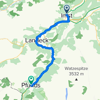
Via 3 - Imst - Pfunds
Trasa rowerowa w Imst, Tyrol, Austria
- 54,7 km
- Dystans
- 398 m
- Przewyższenia
- 241 m
- Spadek


Pfarrgasse 34, Gemeinde Imst nach Stuben 47, Pfunds
Trasa rowerowa w Imst, Tyrol, Austria
- 53,8 km
- Dystans
- 1226 m
- Przewyższenia
- 1080 m
- Spadek


Pfarrgasse 40, Gemeinde Imst nach Stuben 46, Pfunds
Trasa rowerowa w Imst, Tyrol, Austria
- 47,5 km
- Dystans
- 1585 m
- Przewyższenia
- 1431 m
- Spadek
Pfarrgasse 34, Imst nach Stuben 581, Pfunds
Trasa rowerowa w Imst, Tyrol, Austria
- 54 km
- Dystans
- 1226 m
- Przewyższenia
- 1080 m
- Spadek
Odkryj więcej tras
 AC2 Part 1
- Dystans
- 53,2 km
- Przewyższenia
- 287 m
- Spadek
- 87 m
- Lokalizacja
- Imst, Tyrol, Austria
 Imst to Pfunds
- Dystans
- 51,6 km
- Przewyższenia
- 346 m
- Spadek
- 164 m
- Lokalizacja
- Imst, Tyrol, Austria
 Pfarrgasse 34, Gemeinde Imst nach Stuben 47, Pfunds
- Dystans
- 53,8 km
- Przewyższenia
- 1226 m
- Spadek
- 1080 m
- Lokalizacja
- Imst, Tyrol, Austria
 Etappe 2
- Dystans
- 52,7 km
- Przewyższenia
- 300 m
- Spadek
- 114 m
- Lokalizacja
- Imst, Tyrol, Austria
 Imst - Pfunds
- Dystans
- 55 km
- Przewyższenia
- 468 m
- Spadek
- 285 m
- Lokalizacja
- Imst, Tyrol, Austria
 GAP-GAR-E2-Basis
- Dystans
- 54,1 km
- Przewyższenia
- 373 m
- Spadek
- 199 m
- Lokalizacja
- Imst, Tyrol, Austria
 Pfarrgasse 40, Gemeinde Imst nach Stuben 46, Pfunds
- Dystans
- 47,5 km
- Przewyższenia
- 1585 m
- Spadek
- 1431 m
- Lokalizacja
- Imst, Tyrol, Austria
 Pfarrgasse 34, Imst nach Stuben 581, Pfunds
- Dystans
- 54 km
- Przewyższenia
- 1226 m
- Spadek
- 1080 m
- Lokalizacja
- Imst, Tyrol, Austria
Trasy z Imst
Bikepacking od
Z Imst do Nauders
Bikepacking od
Z Imst do Curon Venosta
Trasy do Pfunds
Jednodniowa wycieczka rowerowa od
Z Landeck do Pfunds
Jednodniowa wycieczka rowerowa od
Z Nassereith do Pfunds