
Szablon trasy
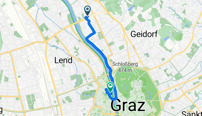
Z Gösting do Graz

- 32 min
- Czas
- 8,6 km
- Dystans
- 90 m
- Przewyższenia
- 107 m
- Spadek
- 16,3 km/h
- Śr. Prędkość
- 406 m
- Maks. wysokość
Enjoy a relaxed ride from the historic suburb of Gösting into the vibrant heart of Graz! Starting near the old Gösting Castle ruins, you’ll find yourself mostly on smooth, paved cycleways that keep things easy and safe—perfect for a leisurely or commuter ride. The route is just under 8.6 km with a handful of gentle ups and downs spread across the journey (don’t worry, the climbs are mild).
As you roll southwards, the terrain is mostly asphalt, passing quiet roads and leafy areas, all the way towards the buzz of Graz’s city center. Graz, a UNESCO World Heritage site, is famous for its blend of modern life and historical charm—so reward yourself with a stroll through the beautiful old town when you arrive.
It’s an easy ride, suitable for most cyclists, with plenty of scenery and even a café or two en route if you’re after a quick break. Enjoy the ride!
Wspólnota
Najlepsi użytkownicy w tym regionie


Od naszej społeczności
Najlepsze trasy rowerowe z Gösting do Graz


Firmenausfahrt 2022-05-19
Trasa rowerowa w Gösting, Styria, Austria
- 25,3 km
- Dystans
- 466 m
- Przewyższenia
- 466 m
- Spadek
Rainleiten 50, Graz nach Mariagrüner Straße 81, Graz
Trasa rowerowa w Gösting, Styria, Austria
- 3,7 km
- Dystans
- 119 m
- Przewyższenia
- 95 m
- Spadek

Platte Rosenheim 4 Laps Test
Trasa rowerowa w Gösting, Styria, Austria
- 50,8 km
- Dystans
- 1113 m
- Przewyższenia
- 1096 m
- Spadek

Platte Hauenstein Lechwald
Trasa rowerowa w Gösting, Styria, Austria
- 17 km
- Dystans
- 483 m
- Przewyższenia
- 465 m
- Spadek


Wildon mit Hupfer über Murberg
Trasa rowerowa w Gösting, Styria, Austria
- 49 km
- Dystans
- 131 m
- Przewyższenia
- 133 m
- Spadek

Parkhaus via the Platte
Trasa rowerowa w Gösting, Styria, Austria
- 13,9 km
- Dystans
- 332 m
- Przewyższenia
- 315 m
- Spadek


Petersgasse25a zu Sandra
Trasa rowerowa w Gösting, Styria, Austria
- 8 km
- Dystans
- 222 m
- Przewyższenia
- 235 m
- Spadek

Odkryj więcej tras
 Platte Rosenheim 4 Laps Test
- Dystans
- 50,8 km
- Przewyższenia
- 1113 m
- Spadek
- 1096 m
- Lokalizacja
- Gösting, Styria, Austria
 Platte Hauenstein Lechwald
- Dystans
- 17 km
- Przewyższenia
- 483 m
- Spadek
- 465 m
- Lokalizacja
- Gösting, Styria, Austria
 Krautwasch
- Dystans
- 82,7 km
- Przewyższenia
- 893 m
- Spadek
- 893 m
- Lokalizacja
- Gösting, Styria, Austria
 Wildon mit Hupfer über Murberg
- Dystans
- 49 km
- Przewyższenia
- 131 m
- Spadek
- 133 m
- Lokalizacja
- Gösting, Styria, Austria
 Parkhaus via the Platte
- Dystans
- 13,9 km
- Przewyższenia
- 332 m
- Spadek
- 315 m
- Lokalizacja
- Gösting, Styria, Austria
 Graz-Thal
- Dystans
- 18,7 km
- Przewyższenia
- 474 m
- Spadek
- 480 m
- Lokalizacja
- Gösting, Styria, Austria
 Petersgasse25a zu Sandra
- Dystans
- 8 km
- Przewyższenia
- 222 m
- Spadek
- 235 m
- Lokalizacja
- Gösting, Styria, Austria
 Eggenberg - LKH
- Dystans
- 7,2 km
- Przewyższenia
- 68 m
- Spadek
- 66 m
- Lokalizacja
- Gösting, Styria, Austria
Trasy z Gösting
Rowerowa od
Z Gösting do Wetzelsdorf
Trasy do Graz
Jednodniowa wycieczka rowerowa od
Z Bruck an der Mur do Graz
Jednodniowa wycieczka rowerowa od
Z Maribor do Graz
Rowerowa od
Z Raaba do Graz
Rowerowa od
Z Wetzelsdorf do Graz