Jak może wyglądać jazda na rowerze w Würzburg.
Jak może wyglądać jazda na rowerze w Kitzingen.

Szybka przejażdżka rowerowa z Würzburg do Kitzingen

Dostosuj własną trasę na podstawie naszego szablonu lub zobacz, jak nasza społeczność najchętniej jeździ z Würzburg do Kitzingen.

Szablon trasy

Z Würzburg do Kitzingen

1 h 12 min
Czas
19,9 km
Dystans
220 m
Przewyższenia
228 m
Spadek
16,6 km/h
Śr. Prędkość
298 m
Maks. wysokość

Set out from Würzburg, a city famed for its hilltop Marienberg Fortress and classic Franconian wines, and enjoy a leisurely 20 km ride southeast to Kitzingen, another wine-loving gem on the Main River. The ride mostly follows smooth, paved surfaces and quiet country roads, making for a relaxed and scenic journey through Bavaria’s rolling wine country.

You’ll tackle a couple of gentle climbs (with a total ascent of just over 220 meters), winding past vineyards and small villages—so there’s no shortage of picture-perfect spots for a quick break. With 95% of the route paved and dedicated cycleways for nearly a fifth of the ride, it’s a stress-free option for cyclists of most levels.

Finish your ride in Kitzingen, known for its crooked Leaning Tower and pretty riverside promenade, and reward yourself with a glass of local Silvaner or Müller-Thurgau. This route is all about relaxed exploration, beautiful scenery, and a taste of Franconian culture.

Wspólnota

Najlepsi użytkownicy w tym regionie

Od naszej społeczności

Najlepsze trasy rowerowe z Würzburg do Kitzingen

Würzburg - Kitzingen - Dettelbach - Kitzingen auf dem Main - Radweg CLONED FROM ROUTE 260235
Rower szosowy
0

Würzburg - Kitzingen - Dettelbach - Kitzingen auf dem Main - Radweg CLONED FROM ROUTE 260235

Trasa rowerowa w Würzburg, Bawaria, Niemcy

Wunderbar zu fahrender Mainradweg von Würzburg bis nach Kleinochsenfurt. Wegen eine Feierlichkeit waren die Wegweisungen zugebaut mit Toilettenwagen und ähnlichem. Der Weg führt also auf einen Schotterweg und schließlich im morastigen, aufgeweichten Feldweg. Ein paar Kilometer weiter in Ochsenfur…
58,1 km
Dystans
134 m
Przewyższenia
111 m
Spadek
Würzburg HBF - Kitzingen HBF
Rower górski
0

Würzburg HBF - Kitzingen HBF

Trasa rowerowa w Würzburg, Bawaria, Niemcy

über Rottendorf, Rothof, Effeldorf, Seligenstadt, Neusetz, Köhler, Escherndorf, Nordheim, Sommerach, Mainsondheim, Albertshofen Escherndorf - Nordheim mit der Fähre für 1,50€ p.P
51,7 km
Dystans
347 m
Przewyższenia
336 m
Spadek
0

Würzburg - Kitzingen über Ochsenfurt

Trasa rowerowa w Würzburg, Bawaria, Niemcy

37 km
Dystans
81 m
Przewyższenia
80 m
Spadek
0

Turmgasse 11, Würzburg nach Hindenburgring-Süd, Kitzingen

Trasa rowerowa w Würzburg, Bawaria, Niemcy

36,4 km
Dystans
191 m
Przewyższenia
164 m
Spadek
0

Würzburg nach Kitzingen Rücktour

Trasa rowerowa w Würzburg, Bawaria, Niemcy

28,4 km
Dystans
188 m
Przewyższenia
171 m
Spadek
0

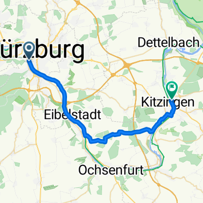
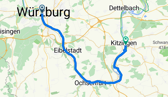
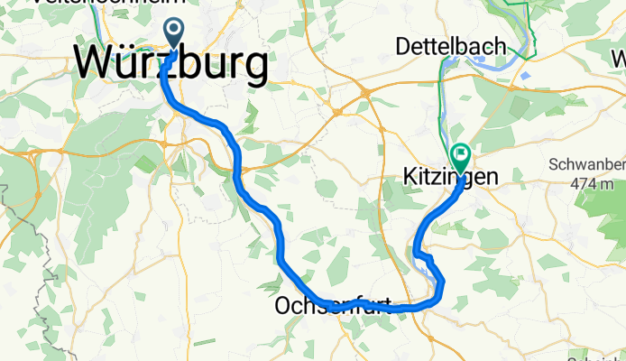
Harfenstraße 2A, Würzburg nach Bismarckstraße 4, Kitzingen

Trasa rowerowa w Würzburg, Bawaria, Niemcy

115,1 km
Dystans
1186 m
Przewyższenia
1172 m
Spadek
0

Würzburg - KITZINGEN

Trasa rowerowa w Würzburg, Bawaria, Niemcy

36,5 km
Dystans
53 m
Przewyższenia
40 m
Spadek
0

01: Würzburg – Kitzingen (Developed)

Trasa rowerowa w Würzburg, Bawaria, Niemcy

Developed
33,2 km
Dystans
93 m
Przewyższenia
81 m
Spadek
0

Alte Mainbrücke, Würzburg nach Friedenstraße 6, Kitzingen

Trasa rowerowa w Würzburg, Bawaria, Niemcy

27 km
Dystans
329 m
Przewyższenia
307 m
Spadek
Rottendorfer Straße 76, Würzburg nach Hindenburgring Nord 1a–1c, Kitzingen
Rower miejski
0

Rottendorfer Straße 76, Würzburg nach Hindenburgring Nord 1a–1c, Kitzingen

Trasa rowerowa w Würzburg, Bawaria, Niemcy

18 km
Dystans
138 m
Przewyższenia
192 m
Spadek
Würzburg-Kitzingen
Rower górski
0

Würzburg-Kitzingen

Trasa rowerowa w Würzburg, Bawaria, Niemcy

Entwurf
21,2 km
Dystans
212 m
Przewyższenia
150 m
Spadek
2

Würzburg-Ochsenfurt-Kitzingen

Trasa rowerowa w Würzburg, Bawaria, Niemcy

Schöne Route vom Hotel Steinburg in Würzburg entlang des Main-Radwanderweges über Ochsenfurt nach Kitzingen. Rückkehr nach Würzburg mit dem Zug möglich.
37,9 km
Dystans
116 m
Przewyższenia
136 m
Spadek

Odkryj więcej tras