
Szablon trasy
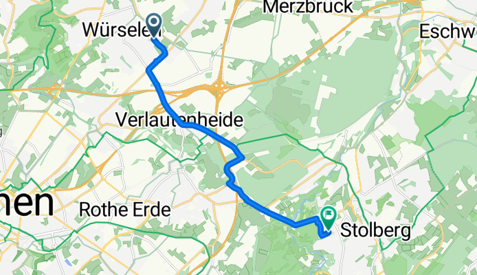
Z Würselen do Stolberg

- 47 min
- Czas
- 13,2 km
- Dystans
- 93 m
- Przewyższenia
- 99 m
- Spadek
- 16,7 km/h
- Śr. Prędkość
- 213 m
- Maks. wysokość
Hop on your bike for a nice ride from Würselen to Stolberg! This roughly 13 km route takes you through the scenic North Rhine-Westphalia countryside, mixing in a good bit of paved surfaces with some stretches of gravel and paving stones—so a hybrid or trekking bike will be a good companion. The path is mostly gentle, but there’s a little over 90 meters of climbing, ensuring you get a bit of a workout without breaking a sweat.
Würselen, known for its close proximity to Aachen and its traditional carnival celebrations, will wave you off. You’ll roll along quiet roads and dedicated cycleways, avoiding busy streets for most of the trip, with tranquil green patches and some forested sections along the way.
Stolberg awaits at the end, famous for its well-preserved medieval old town, crowned by a striking hilltop castle. Why not treat yourself to a pastry at a local café before exploring some of Stolberg’s charming alleys? Don’t forget your camera—those half-timbered houses and castle views are definitely worth a snap!
Wspólnota
Najlepsi użytkownicy w tym regionie


Od naszej społeczności
Najlepsze trasy rowerowe z Würselen do Stolberg

B57 77, Würselen nach Steinkaulplatz 16, Aachen
Trasa rowerowa w Würselen, Nadrenia Północna-Westfalia, Niemcy
- 19 km
- Dystans
- 199 m
- Przewyższenia
- 136 m
- Spadek

Eilendorf Zweifall
Trasa rowerowa w Würselen, Nadrenia Północna-Westfalia, Niemcy
- 13,2 km
- Dystans
- 238 m
- Przewyższenia
- 192 m
- Spadek

Haaner Strasse Hoch, Jägerhausstrasse runter
Trasa rowerowa w Würselen, Nadrenia Północna-Westfalia, Niemcy
- 43 km
- Dystans
- 446 m
- Przewyższenia
- 388 m
- Spadek

20150920_163437.gpx
Trasa rowerowa w Würselen, Nadrenia Północna-Westfalia, Niemcy
- 25,1 km
- Dystans
- 261 m
- Przewyższenia
- 165 m
- Spadek

Severinstraße 26, Aachen nach Von-Coels-Straße 206, Aachen
Trasa rowerowa w Würselen, Nadrenia Północna-Westfalia, Niemcy
- 35,6 km
- Dystans
- 472 m
- Przewyższenia
- 467 m
- Spadek

Eilendorf - Stolberg - Mausbach
Trasa rowerowa w Würselen, Nadrenia Północna-Westfalia, Niemcy
- 11,5 km
- Dystans
- 171 m
- Przewyższenia
- 112 m
- Spadek

Rursee-Route
Trasa rowerowa w Würselen, Nadrenia Północna-Westfalia, Niemcy
- 77,1 km
- Dystans
- 1282 m
- Przewyższenia
- 1291 m
- Spadek

Krefelder Straße 39, Würselen nach Von-Coels-Straße 232, Aachen
Trasa rowerowa w Würselen, Nadrenia Północna-Westfalia, Niemcy
- 8,3 km
- Dystans
- 68 m
- Przewyższenia
- 63 m
- Spadek
Dobacher Straße nach Prämienstraße
Trasa rowerowa w Würselen, Nadrenia Północna-Westfalia, Niemcy
- 9,6 km
- Dystans
- 122 m
- Przewyższenia
- 91 m
- Spadek

Starenweg 32, Würselen nach Würselener Straße 3, Stolberg
Trasa rowerowa w Würselen, Nadrenia Północna-Westfalia, Niemcy
- 9,7 km
- Dystans
- 31 m
- Przewyższenia
- 42 m
- Spadek

Nirmer Straße 29, Aachen nach Obere Steinfurt 5, Stolberg (Rheinland)
Trasa rowerowa w Würselen, Nadrenia Północna-Westfalia, Niemcy
- 7,5 km
- Dystans
- 108 m
- Przewyższenia
- 74 m
- Spadek

Wolfpack
Trasa rowerowa w Würselen, Nadrenia Północna-Westfalia, Niemcy
- 6,6 km
- Dystans
- 103 m
- Przewyższenia
- 46 m
- Spadek
Odkryj więcej tras
 Severinstraße 26, Aachen nach Von-Coels-Straße 206, Aachen
- Dystans
- 35,6 km
- Przewyższenia
- 472 m
- Spadek
- 467 m
- Lokalizacja
- Würselen, Nadrenia Północna-Westfalia, Niemcy
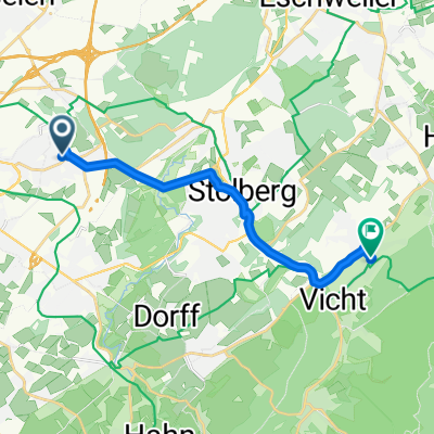 Eilendorf - Stolberg - Mausbach
- Dystans
- 11,5 km
- Przewyższenia
- 171 m
- Spadek
- 112 m
- Lokalizacja
- Würselen, Nadrenia Północna-Westfalia, Niemcy
 Rursee-Route
- Dystans
- 77,1 km
- Przewyższenia
- 1282 m
- Spadek
- 1291 m
- Lokalizacja
- Würselen, Nadrenia Północna-Westfalia, Niemcy
 Krefelder Straße 39, Würselen nach Von-Coels-Straße 232, Aachen
- Dystans
- 8,3 km
- Przewyższenia
- 68 m
- Spadek
- 63 m
- Lokalizacja
- Würselen, Nadrenia Północna-Westfalia, Niemcy
 Dobacher Straße nach Prämienstraße
- Dystans
- 9,6 km
- Przewyższenia
- 122 m
- Spadek
- 91 m
- Lokalizacja
- Würselen, Nadrenia Północna-Westfalia, Niemcy
 Starenweg 32, Würselen nach Würselener Straße 3, Stolberg
- Dystans
- 9,7 km
- Przewyższenia
- 31 m
- Spadek
- 42 m
- Lokalizacja
- Würselen, Nadrenia Północna-Westfalia, Niemcy
 Nirmer Straße 29, Aachen nach Obere Steinfurt 5, Stolberg (Rheinland)
- Dystans
- 7,5 km
- Przewyższenia
- 108 m
- Spadek
- 74 m
- Lokalizacja
- Würselen, Nadrenia Północna-Westfalia, Niemcy
 Wolfpack
- Dystans
- 6,6 km
- Przewyższenia
- 103 m
- Spadek
- 46 m
- Lokalizacja
- Würselen, Nadrenia Północna-Westfalia, Niemcy
Trasy z Würselen
Rowerowa od
Z Würselen do Akwizgran
Trasy do Stolberg
Rowerowa od
Z Akwizgran do Stolberg