
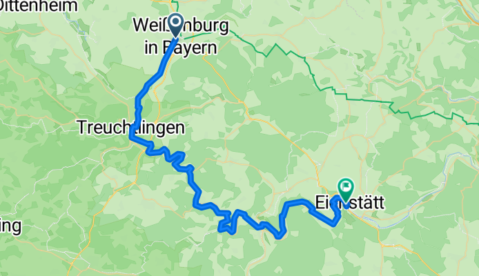
Jednodniowa wycieczka rowerowa z Weißenburg in Bayern do Eichstätt
Dostosuj własną trasę na podstawie naszego szablonu lub zobacz, jak nasza społeczność najchętniej jeździ z Weißenburg in Bayern do Eichstätt.
Szablon trasy
Z Weißenburg in Bayern do Eichstätt

- 2 h 17 min
- Czas
- 36,5 km
- Dystans
- 424 m
- Przewyższenia
- 455 m
- Spadek
- 16 km/h
- Śr. Prędkość
- 593 m
- Maks. wysokość
This scenic bike route starts in the charming town of Weißenburg in Bayern, known for its well-preserved Roman history and medieval old town. Leaving Weißenburg, you’ll wind your way south through rolling Franconian countryside, passing fields and small villages on a mix of quiet roads and rural tracks—perfect for anyone who prefers peace over traffic.
Although most of the ride (about 36 km) is on paved or asphalt surfaces, you’ll also get a taste of adventure with some gravel and unpaved sections. Expect some moderate climbing (about 424 meters of ascent), but the ups are rewarded by sweeping views and fun descents as you approach the Altmühltal valley.
Your destination, Eichstätt, is a photogenic university town nestled on the Altmühl river, famous for its baroque architecture and fossil discoveries. Consider stopping in the historic city center or visiting the impressive Willibaldsburg castle to cap off your ride. It’s a route that blends natural beauty, quiet paths, and a dash of Bavarian culture—ideal for a day’s cycling adventure!
Wspólnota
Najlepsi użytkownicy w tym regionie


Od naszej społeczności
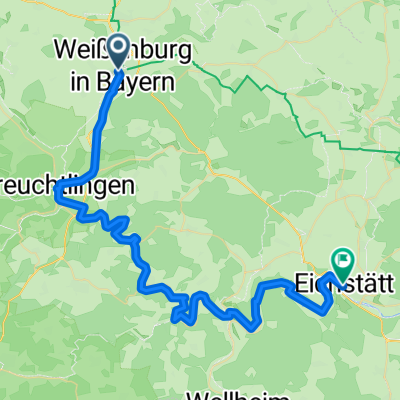
Najlepsze trasy rowerowe z Weißenburg in Bayern do Eichstätt

NAR_5
Trasa rowerowa w Weißenburg in Bayern, Bawaria, Niemcy
- 52,2 km
- Dystans
- 457 m
- Przewyższenia
- 490 m
- Spadek


H 16 Weißenburg - Fossa Karolinga - Altmühlradweg bis Bf Eichstätt-Stadt
Trasa rowerowa w Weißenburg in Bayern, Bawaria, Niemcy
- 55 km
- Dystans
- 452 m
- Przewyższenia
- 481 m
- Spadek

WUG -Eichstätt
Trasa rowerowa w Weißenburg in Bayern, Bawaria, Niemcy
- 55,4 km
- Dystans
- 234 m
- Przewyższenia
- 217 m
- Spadek

Altmuhl-g3
Trasa rowerowa w Weißenburg in Bayern, Bawaria, Niemcy
- 61,5 km
- Dystans
- 134 m
- Przewyższenia
- 162 m
- Spadek

primo
Trasa rowerowa w Weißenburg in Bayern, Bawaria, Niemcy
- 27,8 km
- Dystans
- 275 m
- Przewyższenia
- 314 m
- Spadek

wug-Eichstätt
Trasa rowerowa w Weißenburg in Bayern, Bawaria, Niemcy
- 82,5 km
- Dystans
- 394 m
- Przewyższenia
- 433 m
- Spadek

Marktplatz 8, Weißenburg in Bayern nach Dominikanergasse 2, Eichstätt
Trasa rowerowa w Weißenburg in Bayern, Bawaria, Niemcy
- 55,1 km
- Dystans
- 485 m
- Przewyższenia
- 507 m
- Spadek

Weisenburg- Eichstett
Trasa rowerowa w Weißenburg in Bayern, Bawaria, Niemcy
- 51,5 km
- Dystans
- 208 m
- Przewyższenia
- 246 m
- Spadek

2 Weissenburg-Eichstätt
Trasa rowerowa w Weißenburg in Bayern, Bawaria, Niemcy
- 53,9 km
- Dystans
- 147 m
- Przewyższenia
- 174 m
- Spadek

giorno3
Trasa rowerowa w Weißenburg in Bayern, Bawaria, Niemcy
- 54,4 km
- Dystans
- 160 m
- Przewyższenia
- 201 m
- Spadek

Altmühltal-Radweg: Weißenburg/Wettelsheim - Eichstätt
Trasa rowerowa w Weißenburg in Bayern, Bawaria, Niemcy
- 54,4 km
- Dystans
- 454 m
- Przewyższenia
- 486 m
- Spadek

Radltour2020_Altmühltal_4_Eichstätt
Trasa rowerowa w Weißenburg in Bayern, Bawaria, Niemcy
- 56,1 km
- Dystans
- 133 m
- Przewyższenia
- 155 m
- Spadek
Odkryj więcej tras
 primo
primo- Dystans
- 27,8 km
- Przewyższenia
- 275 m
- Spadek
- 314 m
- Lokalizacja
- Weißenburg in Bayern, Bawaria, Niemcy
 wug-Eichstätt
- Dystans
- 82,5 km
- Przewyższenia
- 394 m
- Spadek
- 433 m
- Lokalizacja
- Weißenburg in Bayern, Bawaria, Niemcy
 Marktplatz 8, Weißenburg in Bayern nach Dominikanergasse 2, Eichstätt
- Dystans
- 55,1 km
- Przewyższenia
- 485 m
- Spadek
- 507 m
- Lokalizacja
- Weißenburg in Bayern, Bawaria, Niemcy
 Weisenburg- Eichstett
- Dystans
- 51,5 km
- Przewyższenia
- 208 m
- Spadek
- 246 m
- Lokalizacja
- Weißenburg in Bayern, Bawaria, Niemcy
 2 Weissenburg-Eichstätt
- Dystans
- 53,9 km
- Przewyższenia
- 147 m
- Spadek
- 174 m
- Lokalizacja
- Weißenburg in Bayern, Bawaria, Niemcy
 giorno3
- Dystans
- 54,4 km
- Przewyższenia
- 160 m
- Spadek
- 201 m
- Lokalizacja
- Weißenburg in Bayern, Bawaria, Niemcy
 Altmühltal-Radweg: Weißenburg/Wettelsheim - Eichstätt
- Dystans
- 54,4 km
- Przewyższenia
- 454 m
- Spadek
- 486 m
- Lokalizacja
- Weißenburg in Bayern, Bawaria, Niemcy
 Radltour2020_Altmühltal_4_Eichstätt
- Dystans
- 56,1 km
- Przewyższenia
- 133 m
- Spadek
- 155 m
- Lokalizacja
- Weißenburg in Bayern, Bawaria, Niemcy
Trasy do Eichstätt
Jednodniowa wycieczka rowerowa od
Z Treuchtlingen do Eichstätt
Jednodniowa wycieczka rowerowa od
Z Gunzenhausen do Eichstätt