
Jednodniowa wycieczka rowerowa z Treuchtlingen do Eichstätt
Dostosuj własną trasę na podstawie naszego szablonu lub zobacz, jak nasza społeczność najchętniej jeździ z Treuchtlingen do Eichstätt.
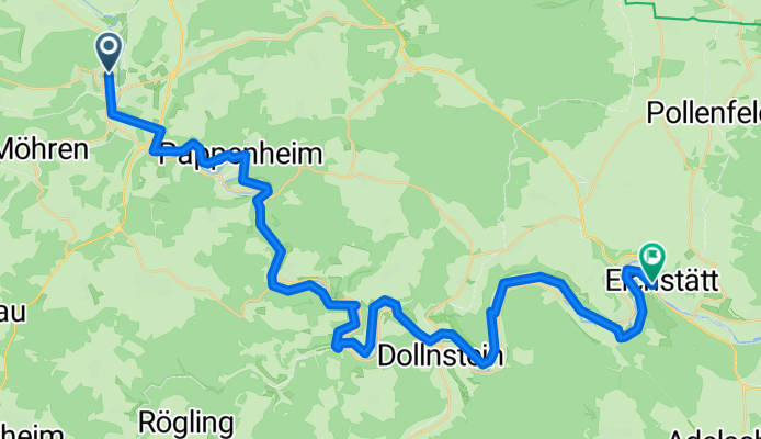
Szablon trasy
Z Treuchtlingen do Eichstätt

- 2 h 3 min
- Czas
- 31,8 km
- Dystans
- 442 m
- Przewyższenia
- 467 m
- Spadek
- 15,4 km/h
- Śr. Prędkość
- 566 m
- Maks. wysokość
Ready for a scenic spin through Bavaria? This route takes you from Treuchtlingen to Eichstätt—about 32 km of rolling countryside, perfect for a relaxed day in the saddle. Treuchtlingen is known as a gateway to the Altmühltal Nature Park and even has a charming castle for a pre-ride photo op.
You'll pedal mostly on smooth, quiet roads, but be ready for some gravel stretches and the occasional unpaved path. With gentle climbs totaling around 440 meters, the ride offers enough variety to keep things interesting without being too tough. The max elevation tops out just above 560 meters, so expect some sweeping valley views.
The route gently winds along the Altmühl River, treating you to glimpses of limestone cliffs and lush meadows—classic Franconian Jura scenery. Eichstätt, your destination, is packed with history: think grand baroque buildings and a UNESCO-listed old town, topped off by views from Willibaldsburg Castle.
All in all, it’s the kind of ride that mixes countryside chill with a splash of old-world culture—just bring a camera and enjoy the ride!
Wspólnota
Najlepsi użytkownicy w tym regionie


Od naszej społeczności
Najlepsze trasy rowerowe z Treuchtlingen do Eichstätt
Treutchtlingen - Eichstätt
Trasa rowerowa w Treuchtlingen, Bawaria, Niemcy
- 42,3 km
- Dystans
- 419 m
- Przewyższenia
- 443 m
- Spadek

Altmühl Treuchtlingen nach Eichstätt
Trasa rowerowa w Treuchtlingen, Bawaria, Niemcy
- 44,2 km
- Dystans
- 270 m
- Przewyższenia
- 294 m
- Spadek

Tag 5 Radtour 2019
Trasa rowerowa w Treuchtlingen, Bawaria, Niemcy
- 57,5 km
- Dystans
- 125 m
- Przewyższenia
- 137 m
- Spadek

Treuchtlingen-Eichstätt
Trasa rowerowa w Treuchtlingen, Bawaria, Niemcy
- 43 km
- Dystans
- 373 m
- Przewyższenia
- 394 m
- Spadek

Taubertour5, Treuchtlingen-Eichstätt
Trasa rowerowa w Treuchtlingen, Bawaria, Niemcy
- 46,4 km
- Dystans
- 295 m
- Przewyższenia
- 278 m
- Spadek

Ciclabile Altmuehl 3
Trasa rowerowa w Treuchtlingen, Bawaria, Niemcy
- 50,7 km
- Dystans
- 333 m
- Przewyższenia
- 369 m
- Spadek

Altmühltal-Radweg 3. Etappe Treuchtlingen - Eichstätt
Trasa rowerowa w Treuchtlingen, Bawaria, Niemcy
- 45,6 km
- Dystans
- 140 m
- Przewyższenia
- 160 m
- Spadek

Tag 4 Radtour 2019
Trasa rowerowa w Treuchtlingen, Bawaria, Niemcy
- 54,8 km
- Dystans
- 187 m
- Przewyższenia
- 200 m
- Spadek

Treuchtlingen nach Eichstätt
Trasa rowerowa w Treuchtlingen, Bawaria, Niemcy
- 45 km
- Dystans
- 424 m
- Przewyższenia
- 438 m
- Spadek

Altmühltal-Radweg Treuchtlingen - Eichstätt CLONED FROM ROUTE 1086850
Trasa rowerowa w Treuchtlingen, Bawaria, Niemcy
- 42,5 km
- Dystans
- 126 m
- Przewyższenia
- 151 m
- Spadek

Altmühltal
Trasa rowerowa w Treuchtlingen, Bawaria, Niemcy
- 45,2 km
- Dystans
- 293 m
- Przewyższenia
- 312 m
- Spadek

Altmühl Wettelsheim-Eichstätt
Trasa rowerowa w Treuchtlingen, Bawaria, Niemcy
- 51,2 km
- Dystans
- 271 m
- Przewyższenia
- 258 m
- Spadek
Odkryj więcej tras
 Taubertour5, Treuchtlingen-Eichstätt
- Dystans
- 46,4 km
- Przewyższenia
- 295 m
- Spadek
- 278 m
- Lokalizacja
- Treuchtlingen, Bawaria, Niemcy
 Ciclabile Altmuehl 3
- Dystans
- 50,7 km
- Przewyższenia
- 333 m
- Spadek
- 369 m
- Lokalizacja
- Treuchtlingen, Bawaria, Niemcy
 Altmühltal-Radweg 3. Etappe Treuchtlingen - Eichstätt
- Dystans
- 45,6 km
- Przewyższenia
- 140 m
- Spadek
- 160 m
- Lokalizacja
- Treuchtlingen, Bawaria, Niemcy
 Tag 4 Radtour 2019
- Dystans
- 54,8 km
- Przewyższenia
- 187 m
- Spadek
- 200 m
- Lokalizacja
- Treuchtlingen, Bawaria, Niemcy
 Treuchtlingen nach Eichstätt
- Dystans
- 45 km
- Przewyższenia
- 424 m
- Spadek
- 438 m
- Lokalizacja
- Treuchtlingen, Bawaria, Niemcy
 Altmühltal-Radweg Treuchtlingen - Eichstätt CLONED FROM ROUTE 1086850
- Dystans
- 42,5 km
- Przewyższenia
- 126 m
- Spadek
- 151 m
- Lokalizacja
- Treuchtlingen, Bawaria, Niemcy
 Altmühltal
- Dystans
- 45,2 km
- Przewyższenia
- 293 m
- Spadek
- 312 m
- Lokalizacja
- Treuchtlingen, Bawaria, Niemcy
 Altmühl Wettelsheim-Eichstätt
- Dystans
- 51,2 km
- Przewyższenia
- 271 m
- Spadek
- 258 m
- Lokalizacja
- Treuchtlingen, Bawaria, Niemcy
Trasy do Eichstätt
Jednodniowa wycieczka rowerowa od
Z Weißenburg in Bayern do Eichstätt
Jednodniowa wycieczka rowerowa od
Z Gunzenhausen do Eichstätt