
Rowerowa z Tempelhof do Mariendorf
Dostosuj własną trasę na podstawie naszego szablonu lub zobacz, jak nasza społeczność najchętniej jeździ z Tempelhof do Mariendorf.
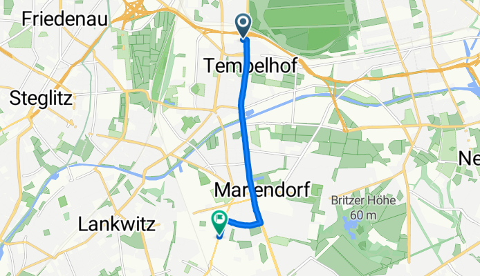
Szablon trasy
Z Tempelhof do Mariendorf

- 42 min
- Czas
- 10,5 km
- Dystans
- 27 m
- Przewyższenia
- 22 m
- Spadek
- 15,2 km/h
- Śr. Prędkość
- 53 m
- Maks. wysokość
This relaxed ride starts in Tempelhof, a lively South Berlin district famous for its vast Tempelhofer Feld—a former airport turned massive urban park. As you pedal south, you’ll cruise mostly on quiet roads and smooth asphalt, so it’s easy-going and safe for most abilities. There’s a gentle climb here and there, but nothing leg-burning; overall, it’s a smooth urban glide.
The route winds roughly 10.5 km towards Mariendorf, a charming neighborhood known for its historical horse racing track and peaceful residential streets. Along the way, you’ll catch a blend of city energy and leafy corners, with plenty of opportunities to grab a coffee or relax in a park. Keep an eye out for pockets of Berlin’s classic architecture and community gardens as you go.
With most of the way paved and traffic pretty light, this is a great route if you want a mellow Berlin cycling experience from one classic Kiez to another—perfect for a casual ride or a laid-back commute.
Wspólnota
Najlepsi użytkownicy w tym regionie


Od naszej społeczności
Najlepsze trasy rowerowe z Tempelhof do Mariendorf


Mariendorfer Weg 21, Berlin nach Im Marienpark 3–11, Berlin
Trasa rowerowa w Tempelhof, Land Berlin, Niemcy
- 5,6 km
- Dystans
- 130 m
- Przewyższenia
- 139 m
- Spadek

Tempelhof-Schöneberg, Berlin nach Rathausstraße 27, Berlin
Trasa rowerowa w Tempelhof, Land Berlin, Niemcy
- 16,6 km
- Dystans
- 72 m
- Przewyższenia
- 73 m
- Spadek

Neukölln, Berlin nach Königstraße 17, Berlin
Trasa rowerowa w Tempelhof, Land Berlin, Niemcy
- 15,2 km
- Dystans
- 54 m
- Przewyższenia
- 62 m
- Spadek

Neukölln, Berlin nach Königstraße 16, Berlin
Trasa rowerowa w Tempelhof, Land Berlin, Niemcy
- 11,5 km
- Dystans
- 91 m
- Przewyższenia
- 98 m
- Spadek

Manteuffelstraße 28, Berlin nach Königstraße 16, Berlin
Trasa rowerowa w Tempelhof, Land Berlin, Niemcy
- 18 km
- Dystans
- 96 m
- Przewyższenia
- 101 m
- Spadek

Kleineweg 75, Berlin nach Wolframstraße 49, Berlin
Trasa rowerowa w Tempelhof, Land Berlin, Niemcy
- 4,5 km
- Dystans
- 62 m
- Przewyższenia
- 61 m
- Spadek

Colditzstraße 34-36, Berlin nach Rathausstraße 100, Berlin
Trasa rowerowa w Tempelhof, Land Berlin, Niemcy
- 9,2 km
- Dystans
- 6 m
- Przewyższenia
- 6 m
- Spadek

Volkmarstraße 21, Berlin nach Alarichstraße 22, Berlin
Trasa rowerowa w Tempelhof, Land Berlin, Niemcy
- 6,5 km
- Dystans
- 16 m
- Przewyższenia
- 13 m
- Spadek


Tempelhof-Schöneberg, Berlin nach Rathausstraße 80, Berlin
Trasa rowerowa w Tempelhof, Land Berlin, Niemcy
- 13,8 km
- Dystans
- 26 m
- Przewyższenia
- 29 m
- Spadek

Ringbahnstraße, Berlin nach Großbeerenstraße, Berlin
Trasa rowerowa w Tempelhof, Land Berlin, Niemcy
- 5,4 km
- Dystans
- 10 m
- Przewyższenia
- 10 m
- Spadek
Ringbahnstraße, Berlin nach Großbeerenstraße, Berlin
Trasa rowerowa w Tempelhof, Land Berlin, Niemcy
- 5,4 km
- Dystans
- 7 m
- Przewyższenia
- 7 m
- Spadek
Odkryj więcej tras
 Manteuffelstraße 28, Berlin nach Königstraße 16, Berlin
- Dystans
- 18 km
- Przewyższenia
- 96 m
- Spadek
- 101 m
- Lokalizacja
- Tempelhof, Land Berlin, Niemcy
 Kleineweg 75, Berlin nach Wolframstraße 49, Berlin
- Dystans
- 4,5 km
- Przewyższenia
- 62 m
- Spadek
- 61 m
- Lokalizacja
- Tempelhof, Land Berlin, Niemcy
 Colditzstraße 34-36, Berlin nach Rathausstraße 100, Berlin
- Dystans
- 9,2 km
- Przewyższenia
- 6 m
- Spadek
- 6 m
- Lokalizacja
- Tempelhof, Land Berlin, Niemcy
 Volkmarstraße 21, Berlin nach Alarichstraße 22, Berlin
- Dystans
- 6,5 km
- Przewyższenia
- 16 m
- Spadek
- 13 m
- Lokalizacja
- Tempelhof, Land Berlin, Niemcy
 Easy ride in
- Dystans
- 3,6 km
- Przewyższenia
- 19 m
- Spadek
- 14 m
- Lokalizacja
- Tempelhof, Land Berlin, Niemcy
 Tempelhof-Schöneberg, Berlin nach Rathausstraße 80, Berlin
- Dystans
- 13,8 km
- Przewyższenia
- 26 m
- Spadek
- 29 m
- Lokalizacja
- Tempelhof, Land Berlin, Niemcy
 Ringbahnstraße, Berlin nach Großbeerenstraße, Berlin
- Dystans
- 5,4 km
- Przewyższenia
- 10 m
- Spadek
- 10 m
- Lokalizacja
- Tempelhof, Land Berlin, Niemcy
 Ringbahnstraße, Berlin nach Großbeerenstraße, Berlin
- Dystans
- 5,4 km
- Przewyższenia
- 7 m
- Spadek
- 7 m
- Lokalizacja
- Tempelhof, Land Berlin, Niemcy
Trasy z Tempelhof
Rowerowa od
Z Tempelhof do Berlin Schöneberg
Rowerowa od
Z Tempelhof do Treptow
Trasy do Mariendorf
Rowerowa od
Z Friedenau do Mariendorf