

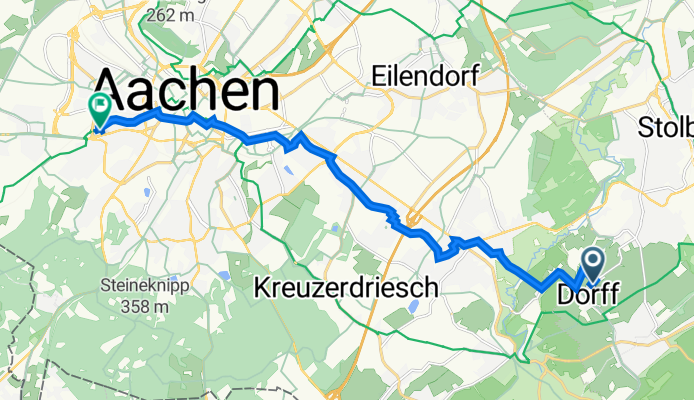
Szablon trasy
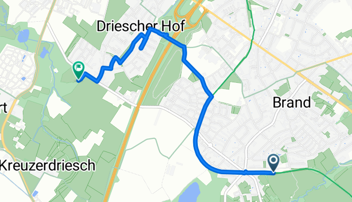
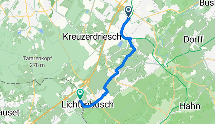
Z Stolberg do Akwizgran

- 1 h 4 min
- Czas
- 18,3 km
- Dystans
- 149 m
- Przewyższenia
- 158 m
- Spadek
- 17,2 km/h
- Śr. Prędkość
- 243 m
- Maks. wysokość
Get ready for a scenic ride from Stolberg to Aachen! Starting in Stolberg, a charming town known for its medieval castle and beautiful old town, the route stretches just over 18 km, taking you west towards the vibrant city of Aachen. Expect mostly smooth sailing: about 85% of the surfaces are paved, with the lion’s share being nice, rolling asphalt.
The ride includes gentle ascents and descents (around 150 meters up, 158 meters down), making it suitable for most cyclists with a bit of stamina. You’ll cruise along quiet roads and dedicated cycling paths for much of the journey—so there’s plenty of opportunity to take it easy and soak in the countryside views.
Once you roll into Aachen, you’ll find yourself in a city famous for its impressive cathedral (a UNESCO site), lively student scene, and top-notch bakeries. Whether you’re in it for the history or the pastries, finishing your ride in Aachen is the perfect reward. Don’t forget to bring your camera and maybe stop for a coffee along the way!
Wspólnota
Najlepsi użytkownicy w tym regionie


Od naszej społeczności
Najlepsze trasy rowerowe z Stolberg do Akwizgran

Beckerstraße nach Lintertstraße
Trasa rowerowa w Stolberg, Nadrenia Północna-Westfalia, Niemcy
- 4,2 km
- Dystans
- 7 m
- Przewyższenia
- 69 m
- Spadek
Bobenden, Aachen nach Raerener Straße, Raeren
Trasa rowerowa w Stolberg, Nadrenia Północna-Westfalia, Niemcy
- 7,1 km
- Dystans
- 64 m
- Przewyższenia
- 31 m
- Spadek

Kornelimunster to Bahnhofplatz, Aachen
Trasa rowerowa w Stolberg, Nadrenia Północna-Westfalia, Niemcy
- 20 km
- Dystans
- 137 m
- Przewyższenia
- 196 m
- Spadek

Mausbach - Eilendorf
Trasa rowerowa w Stolberg, Nadrenia Północna-Westfalia, Niemcy
- 17,2 km
- Dystans
- 147 m
- Przewyższenia
- 179 m
- Spadek

Von Camp Astrid zu Misereor
Trasa rowerowa w Stolberg, Nadrenia Północna-Westfalia, Niemcy
- 16,2 km
- Dystans
- 77 m
- Przewyższenia
- 117 m
- Spadek

Aachen-Brand zum Dom über Nebenstrecke
Trasa rowerowa w Stolberg, Nadrenia Północna-Westfalia, Niemcy
- 7,5 km
- Dystans
- 17 m
- Przewyższenia
- 104 m
- Spadek

Brand - Entenpfuhl
Trasa rowerowa w Stolberg, Nadrenia Północna-Westfalia, Niemcy
- 16 km
- Dystans
- 194 m
- Przewyższenia
- 125 m
- Spadek

Mausbach-Donnerberg-Atsch-Eilendorf
Trasa rowerowa w Stolberg, Nadrenia Północna-Westfalia, Niemcy
- 13,6 km
- Dystans
- 121 m
- Przewyższenia
- 175 m
- Spadek

Aachen-Brand zum Dom über Vennbahn
Trasa rowerowa w Stolberg, Nadrenia Północna-Westfalia, Niemcy
- 8,8 km
- Dystans
- 4 m
- Przewyższenia
- 94 m
- Spadek
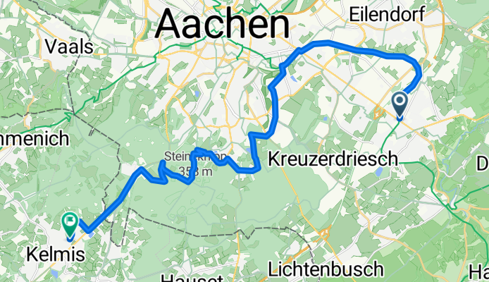
Brandt - Revierweg - Kelmis
Trasa rowerowa w Stolberg, Nadrenia Północna-Westfalia, Niemcy
- 20,1 km
- Dystans
- 229 m
- Przewyższenia
- 243 m
- Spadek

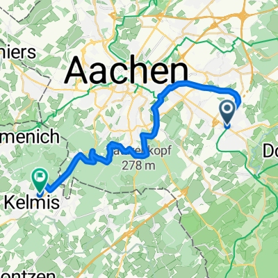
Katzhecke 4, Stolberg (Rheinland) nach Am Gut Wolf 2B, Aachen
Trasa rowerowa w Stolberg, Nadrenia Północna-Westfalia, Niemcy
- 12,6 km
- Dystans
- 78 m
- Przewyższenia
- 125 m
- Spadek
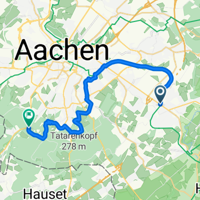
Dorffer Linde 1, Stolberg (Rheinland) nach Vaalser Straße 234, Aachen
Trasa rowerowa w Stolberg, Nadrenia Północna-Westfalia, Niemcy
- 13,9 km
- Dystans
- 124 m
- Przewyższenia
- 192 m
- Spadek
Odkryj więcej tras
 Von Camp Astrid zu Misereor
- Dystans
- 16,2 km
- Przewyższenia
- 77 m
- Spadek
- 117 m
- Lokalizacja
- Stolberg, Nadrenia Północna-Westfalia, Niemcy
 Aachen-Brand zum Dom über Nebenstrecke
- Dystans
- 7,5 km
- Przewyższenia
- 17 m
- Spadek
- 104 m
- Lokalizacja
- Stolberg, Nadrenia Północna-Westfalia, Niemcy
 Brand - Entenpfuhl
- Dystans
- 16 km
- Przewyższenia
- 194 m
- Spadek
- 125 m
- Lokalizacja
- Stolberg, Nadrenia Północna-Westfalia, Niemcy
 Mausbach-Donnerberg-Atsch-Eilendorf
- Dystans
- 13,6 km
- Przewyższenia
- 121 m
- Spadek
- 175 m
- Lokalizacja
- Stolberg, Nadrenia Północna-Westfalia, Niemcy
 Aachen-Brand zum Dom über Vennbahn
- Dystans
- 8,8 km
- Przewyższenia
- 4 m
- Spadek
- 94 m
- Lokalizacja
- Stolberg, Nadrenia Północna-Westfalia, Niemcy
 Brandt - Revierweg - Kelmis
- Dystans
- 20,1 km
- Przewyższenia
- 229 m
- Spadek
- 243 m
- Lokalizacja
- Stolberg, Nadrenia Północna-Westfalia, Niemcy
 Katzhecke 4, Stolberg (Rheinland) nach Am Gut Wolf 2B, Aachen
- Dystans
- 12,6 km
- Przewyższenia
- 78 m
- Spadek
- 125 m
- Lokalizacja
- Stolberg, Nadrenia Północna-Westfalia, Niemcy
 Dorffer Linde 1, Stolberg (Rheinland) nach Vaalser Straße 234, Aachen
- Dystans
- 13,9 km
- Przewyższenia
- 124 m
- Spadek
- 192 m
- Lokalizacja
- Stolberg, Nadrenia Północna-Westfalia, Niemcy
Trasy z Stolberg
Rowerowa od
Z Stolberg do Würselen
Trasy do Akwizgran
Jednodniowa wycieczka rowerowa od
Z Troisvierges do Akwizgran
Jednodniowa wycieczka rowerowa od
Z Roetgen do Akwizgran
Rowerowa od
Z Herzogenrath do Akwizgran
Rowerowa od
Z Würselen do Akwizgran