
Szybka przejażdżka rowerowa z Schliersee do Fischbachau
Dostosuj własną trasę na podstawie naszego szablonu lub zobacz, jak nasza społeczność najchętniej jeździ z Schliersee do Fischbachau.
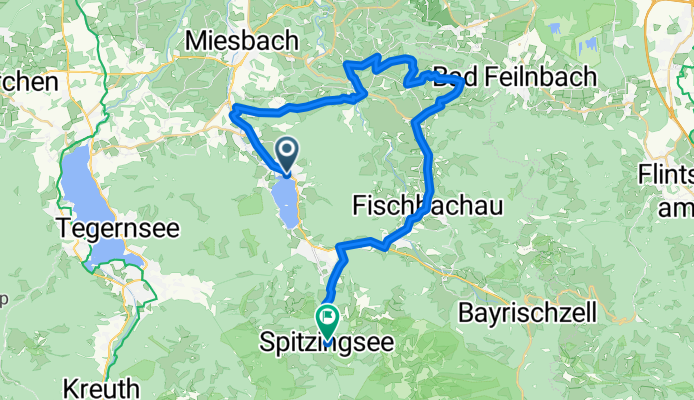
Szablon trasy
Z Schliersee do Fischbachau

- 1 h 5 min
- Czas
- 16,9 km
- Dystans
- 281 m
- Przewyższenia
- 294 m
- Spadek
- 15,7 km/h
- Śr. Prędkość
- 869 m
- Maks. wysokość
Looking for a scenic ride in the Bavarian Alps? This route takes you from the picturesque lakeside town of Schliersee to the charming village of Fischbachau—a perfect outing for those who enjoy nature and Alpine vibes.
Starting in Schliersee, you’ll pedal away from the sparkling lake and classic Bavarian houses, heading southeast along a mix of quiet country roads and gravel tracks (about 27% is gravel, so a trekking or gravel bike is ideal). The route is just under 17 km, with a moderate climb of around 280 meters—enough to get the heart going, but not too intense.
You’ll cruise through lush meadows and serene forests, catching glimpses of the surrounding peaks. The roads are mostly peaceful, with nearly 70% paved surfaces. Expect some beautiful rural scenery and the tranquil atmosphere of Upper Bavaria.
Your ride finishes in Fischbachau, a cozy Alpine village known for its traditional inns and stunning mountain backdrop. Treat yourself to a stop in one of the local cafés or bakeries before heading back or exploring more of the area!
Wspólnota
Najlepsi użytkownicy w tym regionie

Od naszej społeczności
Najlepsze trasy rowerowe z Schliersee do Fischbachau

Hexal Alpen-Triathlon Radstrecke
Trasa rowerowa w Schliersee, Bawaria, Niemcy
- 39,4 km
- Dystans
- 734 m
- Przewyższenia
- 526 m
- Spadek

Triathlonstrecke Hexal Alpentriathlon
Trasa rowerowa w Schliersee, Bawaria, Niemcy
- 40 km
- Dystans
- 817 m
- Przewyższenia
- 491 m
- Spadek

Schliersee Tri
Trasa rowerowa w Schliersee, Bawaria, Niemcy
- 39,5 km
- Dystans
- 774 m
- Przewyższenia
- 468 m
- Spadek

Ganz kurzer Anstieg zum Spitzingsee
Trasa rowerowa w Schliersee, Bawaria, Niemcy
- 7,8 km
- Dystans
- 461 m
- Przewyższenia
- 152 m
- Spadek

Bo-Kö - Etappe 27
Trasa rowerowa w Schliersee, Bawaria, Niemcy
- 10 km
- Dystans
- 106 m
- Przewyższenia
- 118 m
- Spadek

Maxlrainerweg 14, Schliersee nach Spitzingstraße 3, Schliersee
Trasa rowerowa w Schliersee, Bawaria, Niemcy
- 7,1 km
- Dystans
- 380 m
- Przewyższenia
- 84 m
- Spadek

Fischhausen - Josefstal Sptizings Fisch 12km 390hm
Trasa rowerowa w Schliersee, Bawaria, Niemcy
- 11,4 km
- Dystans
- 428 m
- Przewyższenia
- 443 m
- Spadek


Neuhaus - Tegernsee - Spitzingsee
Trasa rowerowa w Schliersee, Bawaria, Niemcy
- 46,2 km
- Dystans
- 921 m
- Przewyższenia
- 934 m
- Spadek

Schliersse Triathlon
Trasa rowerowa w Schliersee, Bawaria, Niemcy
- 39,1 km
- Dystans
- 736 m
- Przewyższenia
- 426 m
- Spadek

Strecke des Garmin Alpentriathlon 2010
Trasa rowerowa w Schliersee, Bawaria, Niemcy
- 38,8 km
- Dystans
- 680 m
- Przewyższenia
- 370 m
- Spadek
Odkryj więcej tras
 Bo-Kö - Etappe 27
- Dystans
- 10 km
- Przewyższenia
- 106 m
- Spadek
- 118 m
- Lokalizacja
- Schliersee, Bawaria, Niemcy
 Maxlrainerweg 14, Schliersee nach Spitzingstraße 3, Schliersee
- Dystans
- 7,1 km
- Przewyższenia
- 380 m
- Spadek
- 84 m
- Lokalizacja
- Schliersee, Bawaria, Niemcy
 Fischhausen - Josefstal Sptizings Fisch 12km 390hm
- Dystans
- 11,4 km
- Przewyższenia
- 428 m
- Spadek
- 443 m
- Lokalizacja
- Schliersee, Bawaria, Niemcy
 Fischbachau-Bad
- Dystans
- 8 km
- Przewyższenia
- 76 m
- Spadek
- 88 m
- Lokalizacja
- Schliersee, Bawaria, Niemcy
 Neuhaus - Tegernsee - Spitzingsee
- Dystans
- 46,2 km
- Przewyższenia
- 921 m
- Spadek
- 934 m
- Lokalizacja
- Schliersee, Bawaria, Niemcy
 e bike tour
- Dystans
- 11,1 km
- Przewyższenia
- 94 m
- Spadek
- 121 m
- Lokalizacja
- Schliersee, Bawaria, Niemcy
 Schliersse Triathlon
- Dystans
- 39,1 km
- Przewyższenia
- 736 m
- Spadek
- 426 m
- Lokalizacja
- Schliersee, Bawaria, Niemcy
 Strecke des Garmin Alpentriathlon 2010
- Dystans
- 38,8 km
- Przewyższenia
- 680 m
- Spadek
- 370 m
- Lokalizacja
- Schliersee, Bawaria, Niemcy