
Bikepacking z Rothenburg nad Tauber do Kelheim
Dostosuj własną trasę na podstawie naszego szablonu lub zobacz, jak nasza społeczność najchętniej jeździ z Rothenburg nad Tauber do Kelheim.
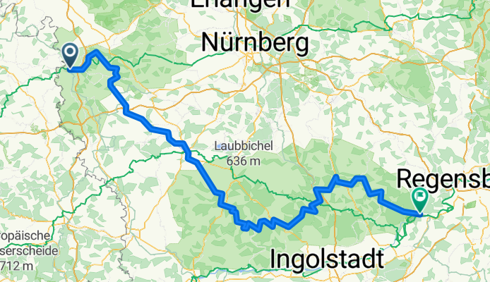
Szablon trasy
Z Rothenburg nad Tauber do Kelheim

- 11 h 59 min
- Czas
- 196 km
- Dystans
- 1413 m
- Przewyższenia
- 1499 m
- Spadek
- 16,3 km/h
- Śr. Prędkość
- 506 m
- Maks. wysokość
This cycling route takes you on an epic ride from the medieval gem of Rothenburg ob der Tauber all the way to Kelheim, winding through some of southern Germany’s prettiest scenery. Starting in Rothenburg, famous for its perfectly preserved old town walls and storybook charm, you’ll cruise mostly on quiet roads and paths, with a nice mix of paved surfaces making up about two-thirds of the way.
The ride stretches just under 200 kilometers, so it’s a solid adventure—either a challenging day trip for the hardcore or an enjoyable two-day tour if you want to really soak it in. Expect gentle climbs totaling around 1,400 meters ascent, with slightly more descending as you near Kelheim, a small riverside town noted for the dramatic Danube Gorge and the impressive Hall of Liberation.
The route feels delightfully rural, mixing traditional villages, peaceful forests, and rolling hills as you go. Around 16% of the surface isn’t detailed, but with 13% gravel and just a smidge of cobblestone, it keeps things interesting. Pack a camera, snacks, and a sense of adventure—you’re in for a real treat between two historic Bavarian highlights!
Wycieczki bikepackingowe
Już podzielone na idealne etapy przez naszą społeczność
Wspólnota
Najlepsi użytkownicy w tym regionie


Od naszej społeczności
Najlepsze trasy rowerowe z Rothenburg nad Tauber do Kelheim

Altmühl-Radweg
Trasa rowerowa w Rothenburg nad Tauber, Bawaria, Niemcy
- 244,4 km
- Dystans
- 291 m
- Przewyższenia
- 371 m
- Spadek

Altmühlradweg: Rothenburg-Kelheim
Trasa rowerowa w Rothenburg nad Tauber, Bawaria, Niemcy
- 244,8 km
- Dystans
- 316 m
- Przewyższenia
- 400 m
- Spadek
Altmühlradweg: Rothenburg-Kelheim
Trasa rowerowa w Rothenburg nad Tauber, Bawaria, Niemcy
- 245,5 km
- Dystans
- 329 m
- Przewyższenia
- 417 m
- Spadek

Altmühltal Radweg
Trasa rowerowa w Rothenburg nad Tauber, Bawaria, Niemcy
- 247,6 km
- Dystans
- 199 m
- Przewyższenia
- 281 m
- Spadek

NN21 Rothenburg - Altmühl - Kehlheim
Trasa rowerowa w Rothenburg nad Tauber, Bawaria, Niemcy
- 237,3 km
- Dystans
- 202 m
- Przewyższenia
- 267 m
- Spadek

2. Durch das Altmühltal von Rothenburg nach Kelheim
Trasa rowerowa w Rothenburg nad Tauber, Bawaria, Niemcy
- 241 km
- Dystans
- 204 m
- Przewyższenia
- 288 m
- Spadek

Altmühltal - Radweg
Trasa rowerowa w Rothenburg nad Tauber, Bawaria, Niemcy
- 247,2 km
- Dystans
- 225 m
- Przewyższenia
- 311 m
- Spadek

Rothenburg bis Kehlheim durch das Altmühltal
Trasa rowerowa w Rothenburg nad Tauber, Bawaria, Niemcy
- 235,5 km
- Dystans
- 202 m
- Przewyższenia
- 280 m
- Spadek
2002-07-15 Altmühltal
Trasa rowerowa w Rothenburg nad Tauber, Bawaria, Niemcy
- 243,3 km
- Dystans
- 171 m
- Przewyższenia
- 256 m
- Spadek

Rothenburg o.d.T. Bahnhof, Rothenburg ob der Tauber nach Hafnergasse 2, Kelheim
Trasa rowerowa w Rothenburg nad Tauber, Bawaria, Niemcy
- 254,4 km
- Dystans
- 142 m
- Przewyższenia
- 222 m
- Spadek
Altmühltal-Radweg
Trasa rowerowa w Rothenburg nad Tauber, Bawaria, Niemcy
- 254,4 km
- Dystans
- 145 m
- Przewyższenia
- 225 m
- Spadek

Altmühltalradweg
Trasa rowerowa w Rothenburg nad Tauber, Bawaria, Niemcy
- 244,2 km
- Dystans
- 148 m
- Przewyższenia
- 228 m
- Spadek
Odkryj więcej tras
 NN21 Rothenburg - Altmühl - Kehlheim
- Dystans
- 237,3 km
- Przewyższenia
- 202 m
- Spadek
- 267 m
- Lokalizacja
- Rothenburg nad Tauber, Bawaria, Niemcy
 2. Durch das Altmühltal von Rothenburg nach Kelheim
- Dystans
- 241 km
- Przewyższenia
- 204 m
- Spadek
- 288 m
- Lokalizacja
- Rothenburg nad Tauber, Bawaria, Niemcy
 Altmühltal - Radweg
- Dystans
- 247,2 km
- Przewyższenia
- 225 m
- Spadek
- 311 m
- Lokalizacja
- Rothenburg nad Tauber, Bawaria, Niemcy
 Rothenburg bis Kehlheim durch das Altmühltal
- Dystans
- 235,5 km
- Przewyższenia
- 202 m
- Spadek
- 280 m
- Lokalizacja
- Rothenburg nad Tauber, Bawaria, Niemcy
 2002-07-15 Altmühltal
- Dystans
- 243,3 km
- Przewyższenia
- 171 m
- Spadek
- 256 m
- Lokalizacja
- Rothenburg nad Tauber, Bawaria, Niemcy
 Rothenburg o.d.T. Bahnhof, Rothenburg ob der Tauber nach Hafnergasse 2, Kelheim
- Dystans
- 254,4 km
- Przewyższenia
- 142 m
- Spadek
- 222 m
- Lokalizacja
- Rothenburg nad Tauber, Bawaria, Niemcy
 Altmühltal-Radweg
- Dystans
- 254,4 km
- Przewyższenia
- 145 m
- Spadek
- 225 m
- Lokalizacja
- Rothenburg nad Tauber, Bawaria, Niemcy
 Altmühltalradweg
- Dystans
- 244,2 km
- Przewyższenia
- 148 m
- Spadek
- 228 m
- Lokalizacja
- Rothenburg nad Tauber, Bawaria, Niemcy
Trasy z Rothenburg nad Tauber
Bikepacking od
Z Rothenburg nad Tauber do Ratyzbona
Jednodniowa wycieczka rowerowa od
Z Rothenburg nad Tauber do Wertheim
Jednodniowa wycieczka rowerowa od
Z Rothenburg nad Tauber do Gunzenhausen
Trasy do Kelheim
Jednodniowa wycieczka rowerowa od
Z Dietfurt do Kelheim
Jednodniowa wycieczka rowerowa od
Z Ratyzbona do Kelheim