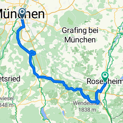
Munich - Rosenheim
- 70,7 km
- 380 m
- 452 m
- Monachium, Bawaria, Niemcy


Szablon trasy
This scenic ride takes you from the bustling city of Munich down to the charming Bavarian town of Rosenheim, covering about 73 km. You'll start in Munich, famous for its beer gardens, historic squares like Marienplatz, and proximity to the Alps. The route rolls mostly on smooth asphalt and quiet country roads, weaving past fields, little forests, and classic Bavarian villages—perfect for soaking in some relaxed rural vibes. Most of your ride is on paved surfaces, so it’s a comfortable cruise, and you’ll enjoy gentle descents along the way.
Expect just a bit of gentle climbing at the outset, with the route gradually descending as you approach Rosenheim. Once you arrive, take time to explore the town’s beautiful riverside setting and lively market square. Rosenheim is known for its vibrant café culture and serves as a gateway to the Alps and lakes of southern Bavaria. All in all, it’s a mellow ride through some truly picturesque countryside—ideal for a day’s adventure!
Wycieczki bikepackingowe
Wspólnota
Od naszej społeczności
Trasa rowerowa w Monachium, Bawaria, Niemcy
Trasa rowerowa w Monachium, Bawaria, Niemcy
Trasa rowerowa w Monachium, Bawaria, Niemcy
Trasa rowerowa w Monachium, Bawaria, Niemcy
Trasa rowerowa w Monachium, Bawaria, Niemcy
Trasa rowerowa w Monachium, Bawaria, Niemcy
Trasa rowerowa w Monachium, Bawaria, Niemcy
Trasa rowerowa w Monachium, Bawaria, Niemcy
Trasa rowerowa w Monachium, Bawaria, Niemcy
Trasa rowerowa w Monachium, Bawaria, Niemcy
Trasa rowerowa w Monachium, Bawaria, Niemcy
Trasa rowerowa w Monachium, Bawaria, Niemcy
Bikepacking od
Bikepacking od
Jednodniowa wycieczka rowerowa od
Jednodniowa wycieczka rowerowa od
Rowerowa od
Rowerowa od