
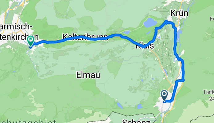
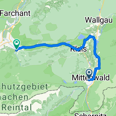
Jednodniowa wycieczka rowerowa z Mittenwald do Garmisch-Partenkirchen
Dostosuj własną trasę na podstawie naszego szablonu lub zobacz, jak nasza społeczność najchętniej jeździ z Mittenwald do Garmisch-Partenkirchen.
Szablon trasy
Z Mittenwald do Garmisch-Partenkirchen

- 1 h 35 min
- Czas
- 23,8 km
- Dystans
- 245 m
- Przewyższenia
- 458 m
- Spadek
- 15 km/h
- Śr. Prędkość
- 990 m
- Maks. wysokość
This scenic ride takes you from the charming alpine town of Mittenwald to the vibrant resort of Garmisch-Partenkirchen. Starting in Mittenwald—famous for its colorful frescoed houses and a centuries-old violin-making tradition—you’ll pedal through rolling meadows and fir forests, with the dramatic peaks of the Karwendel mountains always in sight.
The route is about 24 km, mainly on smooth asphalt and quiet side roads, with a few gravel stretches to keep things interesting. You’ll climb gently out of Mittenwald, gaining around 245 meters—just enough to wake up the legs—before a fun, sustained descent towards Garmisch.
As you approach Garmisch-Partenkirchen, enjoy sweeping mountain views; if you divert slightly, you can spot Zugspitze, Germany’s highest peak. Garmisch is known for its Olympic history and lively town center, perfect for a coffee stop or some well-earned cake. Overall, it’s a relaxed ride with just enough elevation to feel like you really earned those mountain views.
Wspólnota
Najlepsi użytkownicy w tym regionie


Od naszej społeczności
Najlepsze trasy rowerowe z Mittenwald do Garmisch-Partenkirchen


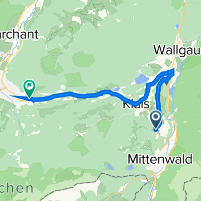
Von Mittenwald bis Garmisch-Partenkirchen
Trasa rowerowa w Mittenwald, Bawaria, Niemcy
- 22 km
- Dystans
- 1376 m
- Przewyższenia
- 441 m
- Spadek

Germany Day 5, 30/490, Mittenwald - Garmisch-Partenkirchen (2013.05.03)
Trasa rowerowa w Mittenwald, Bawaria, Niemcy
- 30,4 km
- Dystans
- 546 m
- Przewyższenia
- 752 m
- Spadek

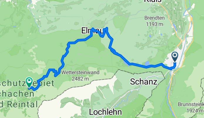
Schloss Elmau - Schachen.gpx
Trasa rowerowa w Mittenwald, Bawaria, Niemcy
- 10,2 km
- Dystans
- 936 m
- Przewyższenia
- 84 m
- Spadek

In Elmau 2, Krün nach Rathausplatz 1–21, Garmisch-Partenkirchen
Trasa rowerowa w Mittenwald, Bawaria, Niemcy
- 10,6 km
- Dystans
- 163 m
- Przewyższenia
- 463 m
- Spadek

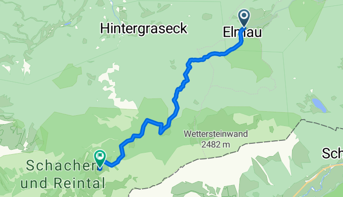
Elmau zum Ludwig Schloß Schachen
Trasa rowerowa w Mittenwald, Bawaria, Niemcy
- 10,7 km
- Dystans
- 921 m
- Przewyższenia
- 63 m
- Spadek
Ballenhausgasse, Mittenwald nach Wildenauer Straße, Garmisch-Partenkirchen
Trasa rowerowa w Mittenwald, Bawaria, Niemcy
- 22,8 km
- Dystans
- 276 m
- Przewyższenia
- 436 m
- Spadek

Obermarkt 27, Mittenwald nach B2, Garmisch-Partenkirchen
Trasa rowerowa w Mittenwald, Bawaria, Niemcy
- 17 km
- Dystans
- 139 m
- Przewyższenia
- 326 m
- Spadek

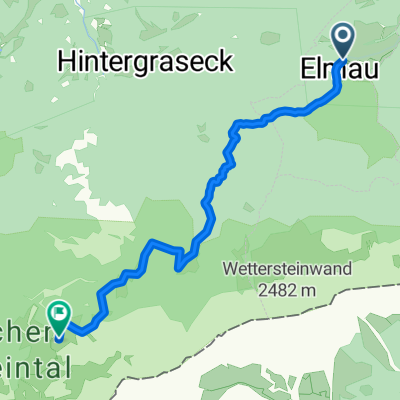
Elmau Hintergraseck
Trasa rowerowa w Mittenwald, Bawaria, Niemcy
- 3,9 km
- Dystans
- 160 m
- Przewyższenia
- 194 m
- Spadek
St 2542, Mittenwald to B2, Garmisch-Partenkirchen
Trasa rowerowa w Mittenwald, Bawaria, Niemcy
- 19,9 km
- Dystans
- 3751 m
- Przewyższenia
- 3933 m
- Spadek

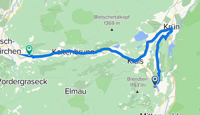
Mittenwald Garmisch
Trasa rowerowa w Mittenwald, Bawaria, Niemcy
- 72,5 km
- Dystans
- 1230 m
- Przewyższenia
- 1442 m
- Spadek
Schacher, Meilerhütte
Trasa rowerowa w Mittenwald, Bawaria, Niemcy
- 9,7 km
- Dystans
- 943 m
- Przewyższenia
- 88 m
- Spadek

Schöttlkarstraße 3, Mittenwald nach Garmisch-Partenkirchen
Trasa rowerowa w Mittenwald, Bawaria, Niemcy
- 18,8 km
- Dystans
- 195 m
- Przewyższenia
- 409 m
- Spadek
Odkryj więcej tras
 Elmau zum Ludwig Schloß Schachen
- Dystans
- 10,7 km
- Przewyższenia
- 921 m
- Spadek
- 63 m
- Lokalizacja
- Mittenwald, Bawaria, Niemcy
 Ballenhausgasse, Mittenwald nach Wildenauer Straße, Garmisch-Partenkirchen
- Dystans
- 22,8 km
- Przewyższenia
- 276 m
- Spadek
- 436 m
- Lokalizacja
- Mittenwald, Bawaria, Niemcy
 Obermarkt 27, Mittenwald nach B2, Garmisch-Partenkirchen
- Dystans
- 17 km
- Przewyższenia
- 139 m
- Spadek
- 326 m
- Lokalizacja
- Mittenwald, Bawaria, Niemcy
 Elmau Hintergraseck
- Dystans
- 3,9 km
- Przewyższenia
- 160 m
- Spadek
- 194 m
- Lokalizacja
- Mittenwald, Bawaria, Niemcy
 St 2542, Mittenwald to B2, Garmisch-Partenkirchen
- Dystans
- 19,9 km
- Przewyższenia
- 3751 m
- Spadek
- 3933 m
- Lokalizacja
- Mittenwald, Bawaria, Niemcy
 Mittenwald Garmisch
- Dystans
- 72,5 km
- Przewyższenia
- 1230 m
- Spadek
- 1442 m
- Lokalizacja
- Mittenwald, Bawaria, Niemcy
 Schacher, Meilerhütte
- Dystans
- 9,7 km
- Przewyższenia
- 943 m
- Spadek
- 88 m
- Lokalizacja
- Mittenwald, Bawaria, Niemcy
 Schöttlkarstraße 3, Mittenwald nach Garmisch-Partenkirchen
- Dystans
- 18,8 km
- Przewyższenia
- 195 m
- Spadek
- 409 m
- Lokalizacja
- Mittenwald, Bawaria, Niemcy
Trasy z Mittenwald
Jednodniowa wycieczka rowerowa od
Z Mittenwald do Innsbruck
Jednodniowa wycieczka rowerowa od
Z Mittenwald do Thaur
Rowerowa od
Z Mittenwald do Scharnitz
Trasy do Garmisch-Partenkirchen
Jednodniowa wycieczka rowerowa od
Z Füssen do Garmisch-Partenkirchen
Rowerowa od
Z Grainau do Garmisch-Partenkirchen